

Check out this amazing drone video of #Hwy1 washout at Rat Creek about 15 miles south of #BigSur. Our crews are on site securing it, assessing damage & starting clean-up/ repairs. Reminder: the road is OPEN from #Carmel thru town of Big Sur. @bigsurkate @BigSurCC @CHP_Coastal pic.twitter.com/rB193DzXhL
— Caltrans District 5 (@CaltransD5) January 29, 2021
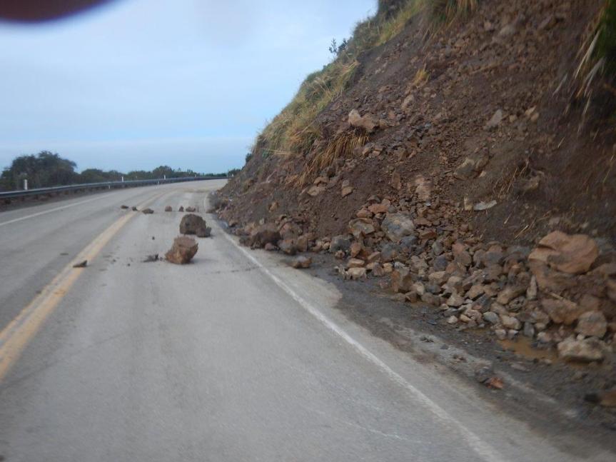
Tag: Slides
Mud Creek article
In the San Jose Mercury News is a very detailed and comprehensive report on the state of the slide and the current work on it, with a series of photos taken by Vern Fischer of the Herald.
You can view it here: https://www.mercurynews.com/2018/05/09/big-sur-nearly-a-year-after-massive-mud-creek-slide-project-intensifies/
Here are a couple of the photos showing current cracks:


(Photo by Vern Fischer)
I have highlighted some new cracks. It is impossible to tell if this is of any significance from a photo, but it would appear the project manager is checking them out, and doesn’t seem to be worried about any imminent threat.
Here is the entrance from the north:

(Photo by Vern Fischer) (Note, this appears to be an earlier shot as the containers are in this photo and they have since been removed)
And here is the arial view. The red line marks where the road will probably go (my guess), if it doesn’t already, but it could be dropped down to the lower bench, if needed, it looks like.

2/8/17 Highway Closed – Nepenthe to Ragged Point


There continue to be more slides from Deetjen’s (PM 43.17) to Mud Creek (PM 8.8) that occurred yesterday, requiring the northern closure to move to Nepenthe (PM 43.8) with a lane closed at Fernwood (PM 47.03)
Top to Bottom: 1 and 2) just south of Grimes Canyon (PM 41.86); 3) near Anderson Canyon (PM 35); 4) around Dolan Point (PM 29.7) around half a mile north of where the CHP were posted; 5) Limekiln Campground (PM 20.76); it slid twice within half an hour mid-afternoon and CT cleared it—photo courtesy of John Davies (Limekiln Campgrounds).6) Deetjen’s (PM 43.17) ; 7)South Coast Center (PM 34.10); 8) Fernwood (PM 47.03)
The inclement weather continues to give us more slides at multiple locations, the newest and largest came overnight at Cow Cliffs (PM 28.35), but additional small slides between Cow Cliffs and now Deetjen’s (PM 43.17) require closure to extend to Nepenthe (PM 44) until further notice.
***NEW INFORMATION***
State Route 1 is now closed between Ragged Pt. (SLO 72.87) and Nepenthe (Mon 44). Another storm is expected tomorrow afternoon, Thursday, Feb. 9.
I Motorists may travel north on State Route 1 from Cambria to Ragged Point (SLO PM 72.87) or south from Carmel to Nepenthe’s (PM 44)
The roadway is not passable between Ragged Pt (SLO 72.87)and Nepenthe (PM 44)
*LOCALS MAY TRAVEL NORTH, CAREFULLY, FROM RAGGED PT. TO LIMEKILN AS THERE ARE 13 LOCATIONS WITH ONLY ONE LANE OPEN DUE TO ROCK/MUDSLIDES.
Thank you for your patience and understanding. Our Maintenance, Geotech and Construction crews continue to work collaboratively and diligently, as much as safely possible in response to these rock/mudslides.
Another update will be provided on around mid-morning tomorrow, Thursday, Feb. 9, or sooner if conditions change.
Susana Z. Cruz nature-flower-blue-motif[1]
Caltrans District 5
Acting Manager
Public Information Office
Gerente Interino
Oficina de Relaciones Públicas
para Caltrans en el Distrito 5
805.549.3138
805.549.3326–fax
Follow us on Facebook
We welcome your feedback: https://www.surveymonkey.com/r/RNBZG55
Highway One Closure Update & Photos, 2/6/17


Photos from this weekend of: 1) Temporary Mesh Netting installed at Big Creek/Cow Cliffs (Sat-PM 28.5); 2) Rock fall at Lucia (Sun-PM 23); Rock fall at Paul’s (Sun-PM 26.10); and Partington Ridge (this am—PM 38.6)
***NEW INFORMATION***
The weekend’s inclement weather gave us various small slides at multiple locations, but thankfully and diligently, we have been able get the roadway clear and provide good news for tomorrow morning, weather permitting.
EFFECTIVE TOMORROW MORNING, TUESDAY, FEB. 7 AT 7 AM (WEATHER PERMITTING):
*DUE TO MORE SLIDE MATERIAL AT PAUL’S SLIDE (PM 21.6), All Motorists may travel north on Hwy. 1 from Cambria to Limekiln Creek Bridge (PM 21.3) or south on Hwy. 1 from Carmel to Lucia (PM 23).
*If you have been following our updates, you know we have dealt with various challenges, below is the status:
1) Mud Creek (PM 8.8)—continues with drilling taking place and daytime one-way traffic control (flagging). However, slide material continues to come down. Expect 20-30 minute delays.
2) The culvert has been replaced/repaired at PM 14.4 and is no longer covered with steel plates just north of Sand Dollar Beach (PM 13.85).
3) At Paul’s Slide (PM 21.6), although we have a temporary stop sign and eventually a traffic signal—MORE MATERIAL IS COMING DOWN AND THERE IS STILL A FULL CLOSURE AT PAUL’S. (see photo).
4) There was a small slide at Lucia (PM 23) this weekend, but has been cleared. (see photo)
5) Temporary mesh netting took place this Saturday at Big Creek/Cow Cliffs (PM 28.35), allowing the roadway to open at this location. (see photo)
6) There was a slide this morning at Partington Ridge (PM 38.6), necessitating the roadway to close at Fuller’s but has been cleared and will be open to traffic. (see photo).
The roadway is not passable between PAUL’S SLIDE (PM 21.6) and LUCIA (PM 23).
Thank you for your patience and understanding. Our Maintenance, Geotech and Construction crews continue to work collaboratively and diligently, as much as safely possible in response to these rock/mudslides.
Another update will be provided on around tomorrow, Tuesday, Feb. 7 afternoon, or sooner if conditions change.
Susana Z. Cruz nature-flower-blue-motif[1]
Caltrans District 5
Acting Manager
Public Information Office
Update, 1/27/17
Today’s update is the same as yesterday’s but with a photo of Cow Cliff from yesterday.

Photo of Big Creek Slide (PM 28.09 ) from yesterday.
Thank you for your patience and understanding. Our Maintenance and Geotech crews have been working diligently, clearing, cleaning, and scaling as much as safely possible in response to these rock/mudslides.
***INFORMATION***
*We have numerous slides between the closure points, the largest being at: Mud Creek (PM 8.8, shown above), Paul’s Slide (PM 21.6), Big Creek (PM 28.09) and at Anderson Cyn. Bridge (PM 35.4)
CONTINUOUS SLIDES KEEP ROAD CLOSED FROM RAGGED POINT (SLO PM 72.87) TO FULLER’S (MON PM 42) DUE TO ROCK/MUDSLIDES AT MULTIPLE LOCATIONS. All Motorists may travel south on Hwy. 1 from Carmel to Fuller’s (PM 42) or travel north from Cambria to Ragged Point.
CHP is monitoring the closure at Fuller’s.
Another update will be provided tomorrow afternoon, Saturday, Jan. 28, or sooner if conditions change.
Susana Z. Cruz
Caltrans District 5
Public Information Officer/
A couple slide photos by DMT
Taken yesterday by Michael Troutman. Top to Bottom: Paul’s Slide, Cow Cliff, Anderson.
Also, scaling will be taking place today at Cow Cliff’s, but will make time and space for locals to get through, when possible. Unsure re Anderson, yet.


Central Big Sur Interactive Slide Map
The following link by JWC will take you to a map with of the current, up-to-date slides and closures on OpenStreetMap, which may NOT work across all platforms and devices.
The PDF maps have been tested across different platforms, etc. and they work great as general area maps with links that open photos of the locations shown on the map (click on the names to open photos).
—
My wonderful, mysterious, map-making friend completed the second – Central portion – map of the Big Sur Coast. It goes north to Juan Higuera Creek. Here it is, but like the first one (South), it is available as the first page of my “pages” links to the right.

Road Update #2 and Big Creek Photos, 1/23/17
Paul’s Slide has gotten worse, so if you could reach it, no escorts are being allowed. Here are a number of photos of the Big Creek Slide by Dave Nelson, Thomas Leahy, David Halterman, and Mark Readdie. This is not going to be opened up anytime soon. This notice below is what Cal Trans sent out, but I heard from a local that a couple people from Esalen got through 35. Only way out for some people.
\”NEW INFO—PAUL’S SLIDE (PM 21.6) HAS WORSENED, NOT PASSABLE/ESCORTABLE TODAY…NEW SLIDES KEEP ROAD CLOSED FROM FULLER’S TO RAGGED POINT
+++CHP CONTINUES WITH NORTHERN CLOSURE OF HWY. 1 AT FULLER’S (PM 42)–EMERGENCY VEHICLES ONLY ALLOWED THRU ANDERSON CLOSURE–LOCALS WILL BE CITED BY CHP AND NOT ALLOWED TO TURN AROUND+++
State Route 1 CONTINUES closed from Ragged Point (SLO PM 72.87) to Fuller’s(MON PM 42) due to rock/mudslides in multiple locations.”


Deetjen’s damage, 1/22/17
Mud slides and trees. Photos by Abraham Newell.


Cal Trans Update, Sun. 1/22/17
CALTRANS
HiGHWAY `1 UPDATE
Sunday, January 22
11:00 AM
+++EMERGENCY VEHICLES ONLY NOW ALLOWED THRU ANDERSON CLOSURE–LOCALS WILL BE CITED BY CHP AND NOT ALLOWED TO TURN AROUND+++
State Route 1 CONTINUES closed from Ragged Point (SLO PM 72.87) to Anderson Canyon Bridge (MON PM 35.4) due to rock/mudslides in multiple locations. The newest slide is located at PM 35, requiring the closure to move from Lucia (PM 23) to Anderson Canyon Bridge (PM 35.4).
LOCALS AND GUESTS ONLY MAY TRAVEL SOUTH TODAY, SUNDAY FROM 7 AM UNTIL 3 PM , FROM ESALEN (PM 32.4) TO BE ESCORTED BY A PLOW TRUCK AROUND PAUL’S SLIDE (PM 21.6) IN ORDER TO TAKE COUNTY ROAD “NACIMIENTO FERGUSON” (PM 18.90) SOUTH, AS THERE IS AN ACTIVE SLIDE AND FULL CLOSURE AT MUD CREEK (PM 8.8) . NO NORTHBOUND TRAFFIC WILL BE ALLOWED.
Who can travel where is open to some considerable doubt due to wording, issued and reissued by the PIO, but the road is definitely closed to all in at least two locations, including locals.
ROADWAY IS ONLY PASSABLE TO LOCALS, ONLY WHERE MENTIONED ABOVE, IN BETWEEN THE CLOSURES AT THIS TIME.
Another update will be provided TOMORROW morning, Monday, Jan. 23 or sooner if conditions change.
The pictures are from this morning of Mud Creek (PM 8.8) and Anderson Cyn Slide (PM 35.4) respectively –where’s there’s barely space for Emergency Vehicles to be allowed thru by CHP.


