Soberanes Fire, Day 40, 8/30/16

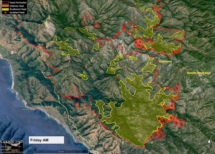
From the USFS around 11 am – “The #SoberanesFire is getting more active in the Big Sur River drainage and smoke is now visible from the Highway 1 and the Pfeiffer Big Sur State Park. The fire is burning pockets of unburned fuel in the river drainage and is not threatening containment lines at this point. Four helicopters are enroute to drop water on the active fire to guide it down the river drainage. The increased activity is a result of increased winds and low relative humidity. We will keep you posted.”

From Linda Rowland-Jones last night on Partington:

image

John Chesnut map:

image

From last night’s community meeting in Big Sur at MAF:

image

Detailed briefing from the Alaska Team IC and a return of a familiar face in Air Operations Chief Mark Nunez, who served as IC for Pfeiffer Fire. Nunez has been working Soberanes since the first week. Good air operations near Partington today to slow western progress. With existing winds, western side of the fire is priority one. Near Jamesburg and Tassajara, Jamesburg, Cachagua Community News area, structure protection crews continue their assessments. Google Earth images of fire also reviewed so public could see fire lines, dozer lines and contingency lines.

Yesterday afternoon looking East from Partington Cove, photo by Suzy Cowman Tennyson:

image

4:45 am – Today’s Maps

And each day the two fires appear to grow closer together by 1 mile per the USFS calculations:

image

Soberanes to Chimney Map in PDF (at least the Chimney has stopped growing.)

image

IR Topo Map in PDF

image

So Ops Map in PDF

Here are the fire and weather predictions

imageimage


Chimney Fire, 8/29/16

After practically no growth yesterday, it looks as if the fire became very active on the western flank and a bit north overnight. It is pushing right up to the Silver Peak Wilderness, with many dozer lines created to try and keep it out of the wilderness.

image

IR Topo Map in PDF link

image

PIO Map in PDF Link

image

Ops Map to PDF link

Soberanes Fire, Day 39, 8/29/16

7:30 PM – Contrary to rumor, there is NOT a mandatory evac of Partington Ridge, per a resident there.

7:00 pm – I have been meaning to write of what I witnessed yesterday. About 11 am, we drove by a staging of many fire trucks at approximately MM 41.6 or so. When we came home after 5 pm, the area was empty, with only cones and tape out. I heard later that they had staged up Partington Ridge, and this morning’s “structure protection” map for Partington confirmed this. The IMT has been preparing for this, given the predicted winds, so none of this is a surprise.

7:00 pm – per Keith Vandevere: “Fire is very likely in Pick Creek now. As of 1:30, the MODIS satellites had active fire from Logwood Ridge all along the edge of the Pick Creek drainage nearly to South Fork Camp. It will have to burn across the Pick Creek drainage before challenging the line on the Coast Ridge, but it may be in the process of doing that.”

6 pm – many of us have been watching a plume all afternoon. Right now, it is quite winded sitting over or behind Partington Ridge. Here is a photo taken earlier showing behind Partington Ridge by Lyndall Demere. It is also East of Partington Cove. What I don’t like in this photo is the “Orange glow” within the column, which indicates to me active fire.

image

Noon – recent fires history map (looks to only cover the 1999 Kirk Hare, 2008 Basin, and 2013 Pfeiffer, but interesting none-the-less.

image

And … The Soberanes and Chimney Fires are another mile closer together…

image

6 am – Here are today’s maps:

image

Topo Map Link to PDF

image.jpeg

So Ops Map Link to PDF

And here are a couple new ones – Structure Protection Maps (5 of them, total, but only including the first 3 today, will add the last 2 tomorrow) for various areas:

image


Partington Structure Protection Map in PDF

image


Highway 1 Structure Protection, map 1, Link to PDF

image.jpeg

Highway One Structure Protection, map 2, link to PDF

Here are the weather and fire predictions for today:

imageimage


Soberanes Fire, Day 38, 8/28/16

7:00 pm – Okay, I am back. I was off to Carmel Valley to the Folktales Winery for a lovely afternoon of music, wine, food, and great people. I met so many people I had only “met” online before. It was a real treat, and so nice to take the day off. In any event, there is a community meeting at MAF tomorrow night, and a new evac warning issued which I posted separately. Here is the meeting notice;

image

9:00 am – photo back behind Partington taken by Sula Nichols’s daughter Layla. So sad.

image

9:00 am – finally got the IR Topo map up this morning.

image

IR Topo Map link to PDF

There is no available IR Topo map this morning at 5:30 am. I will try again later, but Today, starting about 10 am, I will be offline much of the day so that I can attend the Folktales Winery Soberanes Fire Fundraiser.

Here is the South Ops Map:

image.jpeg

So Ops Map in PDF

Here are the Fire and Weather Behavior forecasts for today:

imageimage


Chimney Fire, 8/27/16

John Chesnut map, as you can see from all the maps, the majority of the fire growth is on the northern section of the fire.

image

image

IR Topo Map Link to PDF

image

Ops Map Link to PDF

image

Soberanes Fire, Day 37, 8/27/16

“All,

The IC from the latest team, from Alaska, would like to know if the Big Sur folks would be interested in a meeting to let them know what the continuing plan is.
It is the same strategy as they are doing now….

Would you mind sending out an email and posting the question to see if there is any interest?

It would be a quick informal meeting.

Thanks,

Martha

Martha Karstens
Chief”

******************

From Steve Harper:

“This comes directly from Tassajara. I am not giving the name of the person it came from, but can attest to it comes from the top:
“It has been very confusing. The man who gave us the “absolutely no help” message, had seemed very supportive when at Tassajara, and also seemed very uncomfortable as he was giving us that new message. The day after that no message, 2 safety officers (or something) came to ZMC from the FS and asked if we needed anything. Yesterday they came back with the woman who helps to assign crews and they looked at our request for help to cut line. She said she will do her best to get us a crew for 2 days, which would be a big help. One “problem” it appears is that we have done so much prep and spent so much on equipment that they think we don’t need anything. Maybe this is true compared to others. My feeling is that the main thing that would be helpful to us is to have even one or two more people who have actually fought fire there when the fire comes. We have great crew, but very inexperienced.

These are just my thoughts and should not be taken as true. We are trying to decide on our strategy and I or someone will include you as we know. Thank you so much for your support.”

Steve suggests emailing SoberanesFire2016@gmail.com to express your concerns.

John Chesnut map:

image

August 27, 2016

DAILY UPDATE

Fire Information Phone (831)204-0446
soberanesfire2016@gmail.com
http://inciweb.nwcg.gov/incident/4888/
http://www.fire.ca.gov/current_incidents/incidentdetails/Index/1348

Incident: The Soberanes Fire was started by an Illegal campfire on the morning of July 22, 2016, in the Garrapta State Park. The fire is burning in areas of previous large fires including the Basin Complex in 2008 and the Marble-Cone Fire in 1977.
Location: Los Padres National Forest, Ventana Wilderness, Monterey County, CA
Agency Jurisdiction: CAL FIRE San Benito-Monterey Unit/Los Padres National Forest

Current Size: 91,543 acres (54,259 acres CA-LPF, 37,194 acres CAL FIRE)
Containment: 60% Cause: Illegal campfire Injuries: 1 fatality, 4 injuries
Structures Destroyed: 57 homes, 11 outbuildings Structures Threatened: 410
Current Resources: Crews: 22 Engines: 85 Helicopters: 12 Dozers: 19 Water Tenders: 14
Total Personnel: 1501

Incident Command: Alaska Interagency Incident Management Team, Tom Kurth Incident Commander. The incident is no longer in unified command with Cal Fire, many Cal Fire resources are still being utilized.

Fire Restrictions: Forest Order 05-07-16-15 Fire Use Restrictions – Level IV Fire Restrictions. This Order is effective from August 23, 2016, through the end of the official 2016 fire season.

Current Situation: Yesterday, a thick marine layer kept fire activity along the coastal area low. Weather stations positioned around the fire area continue to show significant differences in humidity between the lower and higher elevations. Interior portions of the fire continue to grow slowly. Similar fire behavior is expected today and no threats to fire containment lines are anticipated.

Additional structure protection and firing operation crews have arrived and are taking this time of slow fire growth to develop preparing for potential fire movement. Suppression line repair work continues on the northern perimeter of the fire.

Wilderness Tactics: To reduce the impacts associated with fire suppression activities in wilderness areas, fire managers and firefighting crews continue using Minimum Impact Suppression Tactics (MIST) as much as possible. The steep, rugged terrain of the Ventana Wilderness is inherently treacherous to firefighters. Most direct fireline is being constructed near the perimeter in areas that have been pretreated and supported by aircraft. The inaccessibility into the Ventana Wilderness along much of the fire’s east side continually requires patience, as well as slow and steady hard work from the crews, as they look for options to construct direct line.

US Forest Service Road and Trail Closures: A forest closure order has been implemented to close the trails and roads within the Los Padres National Forest, Monterey Ranger District pursuant to USC 551 and 36 CFR 261.50(a). The order prohibits going into or being upon National Forest System lands within the Soberanes Fire area. For a complete list of closures please visit: http://www.fs.usda.gov/lpnf . The following sites are open: Pfeiffer Beach Day Use, Mill Creek Day Use, Willow Creek Day Use, Sand Dollar Day Use, Kirk Creek Campground, Nacimiento Campground, Ponderosa Campground and Plaskett Creek Campground.

California State Park Closures: Point Sur Light Station State Historic Park is open and guided tours will resume today. Go to http://www.pointsur.org for more information. Portions of Julia Pfeiffer Burns State Park including the McWay Falls trail have opened. All lands and trails east of the parking lot and the campground remain closed. The Big Sur Lodge is open, however, Pfeiffer Big Sur State Park Day Use and Campgrounds remain closed. Go to http://www.bigsurlodge.com for more information.

The following park units remain closed:· Andrew Molera State Park -All park lands closed to public entry; Pfeiffer Big Sur State Park – All park lands except the Big Sur Lodge closed to public entry; Garrapata State Park – All park lands east of Hwy 1 closed to public entry.
Evacuation Orders and Warnings: An evacuation ORDER remains in effect for Coast Ridge Rd. from mile marker 1.5 to Marble Peak at the end of the road. A WARNING remains for Tassajara Road from Carmel Valley Road to the Tassajara Hot Springs Zen Center. This area includes all roads that lead from the above described roads.

Donations: Local relief efforts to the fire victims have been provided by the Coast Property Owners Association (CPOA) and the Community Foundation for Monterey County. Donations can be made to the CPOA at Coast Property Owners Association, PO Box 59, Big Sur, CA 93920 or the Community Foundation for Monterey County, 2354 Garden Road, Monterey, CA 93940 (831)375-9712.

The Red Cross prepares for, responds to, and helps people recover from disasters big and small. For any unmet disaster related needs, please call their 24 hour hotline at 1-866-272-2237.

####

6:00 am – Here are the usual maps for today, and a new one I found:

image

Distance between fires map in PDF

image

IR Map in PDF link

image

So Ops Map in PDF link

Here are the weather and fire behavior predictions, which are contained within the much larger Incident Plan (42 pages) so they are screen shots, and as such do not have links.

image


image


Chimney Fire, 8/26/16

Noon – Here is the progressive map

image

Progressive Fire Map in PDF

John Chesnut Maps:

imageimage

Am report:

#CHIMNEYFIRE: Here’s the full Cal Fire morning report, 7 a.m. Friday, Aug. 26

Chimney Fire
Incident Update
http://www.fire.ca.gov
Date: 8/26/2016 Time: 6:00AM
Fire Information Line: 805-543-2444

Incident Start Date: 8/13/2016 Incident Start Time: 4:03 PM
Incident Type: Vegetation Fire Cause: Under Investigation (but Cal Fire has determined that the fire was not set deliberately.)
Incident Location: Chimney Rock Rd. & Running Deer Rd., South of Nacimiento Reservoir

Acreage: 45,008 acres Containment: 47%
Expected Containment: 09/03/2016 Injuries: 1
Structures Threatened: 1,898
Structures Destroyed: Residences 49 Other 21
Structures Damaged: 8

RESOURCES
Engines: 328 Water Tenders: 69 Helicopters: 16 Air Tankers: 7 Hand Crews: 106 Dozers: 46 Other: 3 Total Personnel: 4,028

Cooperating Agencies: California Highway Patrol, California State Parks, San Luis Obispo County Sheriff, Red Cross, California Department of Corrections and Rehabilitation, California Conservation Corps, PG&E, San Luis Obispo Air Quality Board, San Luis Obispo Public Works, Paso Robles Fire Department, Monterey Co. Water Resource Board, California Department of Fish and Wildlife, US Army Camp Roberts, CAL-OES, San Luis Obispo County OES, Monterey County Sheriff, Monterey County OES, Fort Hunter Liggett, and Los Padres National Forest.

CURRENT SITUATION
Overnight, the fire behavior remained active, but cooler temperatures and higher relative humidity helped firefighters increase containment lines throughout the night. Today, anticipated onshore low-level flow will strengthen, with a deeper marine layer, leading to lower temperatures. The Hearst Castle and Hearst Castle Infrastructure remain threatened.
Threats remain with evacuation orders to Oak Shores, Christmas Cove, Cal Shasta, Bryson Hesperia and Lake San Antonio.
As with all evacuation orders and warnings, these are implemented for the safety of the public and firefighters. Fire personnel are working in extreme fire conditions around the clock to contain and control the fire. Please do your part to be prepared to evacuate by visiting http://www.readyforwildfire.org. Unified command with Fort Hunter Liggett and Los Padres
National Forest.

Evacuations: Evacuation orders were lifted for the communities of Tri-County, Cal Shasta, Rancho Del Lago, and South Shore
Village on Thursday, August 25, 2016 at 12:00 PM. Property owners and residents of the Tri-County, Cal-Shasta, Rancho Del Lago and South Shore Village Ranch Communities are asked to carry a government issued identification card, current utility bill, or other similar evidence showing an address within Tri-County, Cal-Shasta, Rancho Del Lago, and South Shore Village.
Evacuation orders remain in place for Christmas Cove, Oak Shores, North Shore Boat and Ski, Laguna Vista, Lake San Antonio, Sapaqua Valley, and Bryson Hesperia in both San Luis Obispo and Monterey Counties. Members of the general public are asked to avoid the Tri-County, Cal-Shasta, Rancho Del Lago, and South Shore Village area due to large numbers of fire resources in the area and to respect private property rights of these communities.

KATHE’S NOTE: After some confusion late Thursday, Aug. 25, (me getting a different report from a Cal Fire spokesman than my Tribune colleague was given a little earlier in the evening), Cal Fire officials confirmed that the evacuation warning remains in effect on San Simeon Creek Road, Van Gordon Creek Road, Keystone Mine Road and Red Mountain Road. I’ll check in a while to make sure that’s still the case.

Evacuation Centers:
Flamson Middle School Small Animals – Chimney Fire Animal Shelter can be contacted at (805)423-4934
2405 Spring Street Large Animals – Horse Emergency Evacuation Team (HEET) 805-466-7457
Paso Robles, CA 93446 Large and Small Animals – Chimney Fire Animal Relief (805)423-4934

Road & Waterway Closures:
G14 Interlake Road from Lake Nacimiento Dam to Bryson Hesperia Road. Traffic control points are being manned by CHP at Interlake Road at Bryson Hesperia Road, as well as Interlake Road at Lake Nacimiento. Las Tables arm on Lake Nacimiento is closed. All boating activity is closed west of the Las Tables arm on Lake Nacimiento, including all vessel launching west of Las Tables arm on Lake Nacimiento.

7:00 am – Chilly, and not as smokey as I am sure it will get later in the am. Right now, I can actually see Cone Peak and Willow Creek Top, which hasn’t been the usual up here.

image

IR Interpretation Map in PDF

image

IR Top Map 2 in PDF

image.jpeg

Ops Map in PDF

Soberanes Fire, Day 36, 8/26/16

Noon: Here is the progression map from the inception until this morning’s mapping:

image

and for you purists, here is the link:Progressive Map link to PDG

John Chesnut maps:

imageimage

7:45 am – Just in this report from Joelene who attended last night’s meeting at Cachagua Store:
“Howdy the briefing last evening was very informative. Many concerned residents from Tassajara showed up. The USFS is going to take over this fire Friday, but Cal Fire is here to stay as long as this fire is active. Operations will work on the bounds of fire lines. Strike teams are at structures in Miller Canyon and Pine Valley. Please know that while the USFS has a different approach or tactics, Cal Fire is here to stay and protect us. In order for them to help us we must help them. If you feel lack of communication is occurring, contact 8312040446. Or e mail soberanesfire2016@gmail.com if still no return response, keep trying. As their priority is lives first, structures are close behind. They work closer to the current fire breaks and as the fire moves closer, the crews move outward to structures and properties. Those who have yellow paper that says undefendable, please contact a Cal Fire official and ask them to reassess the place, especially if you have done more clearing work. They are not abandoning anyone. They need to be able to protect what is accessible. They need to be able to enter your property AND turn around, especially up Tassajara. Right now warning evacuation remains, and roads are open. You can come and go, with vigilance that this is apt to change suddenly. With all due respect, Cal Fire is working with the sheriff department on communications for a window advance notice of twelve hours of a hard or soft closure, IF back firing operations make the decision to back fire Henningson Ridge. It may not have to be done. With the good old fog walking in, the fire has been low and slow burning, making it easier for fire crews and personnel’s to work it…. Much to our long standing patience….. Cal Fire and all the fire technicians appreciate your patience and support. As much as you do, they want this fire to be beaten as soon as possible and it will come to pass. Just a bit longer. Please continue your wonderful support and patience.”

6:30 am – This is becoming surreal … Day 36. Five weeks, down – now starting the 6th week of monitoring this fire. Lots of fog on the coast, pretty thick, this am, with the smoke sitting on top of that. AND, it is amazingly cool, almost cold. At least I can see Cone Peak, this am.

First up – the IR Topo map and link:

image

Link to IR Topo Map in PDF

image

So Ops link to PDF Map

And here are the fire behavior and weather predictions. These come from much larger reports, so they are screen shots, and there are no direct links to these pages.

imageimage