Sprinkles & Lightning

1pm – update, the lightning has stopped. I hope it doesn’t come back…

June 22, 2008, lightning started a multitude of fires state wide. Ours was the Gallery Fire which morphed into the Basin. It was this fire that prompted this blog.

I am hearing thunder today, experiencing the lightest of sprinkles, and a muggy heavy heat I have not experienced since Hawaii, Zanzibar, and other tropical locales. The dogs are freaking over the thunder, as they always do. The coast is blanketed in fog down here. Dry lightning is not a good thing for us, as dry as we are, particularly up here in the hills.  Keep vigilant, and keep an eye out. We are all look-outs, now.

Before & After – a wildflower field

DSC_7525

Above photo by Howard Jones

IMG_2269

Above photo by Tony Shelfo

And as you can see, a fence (see top photo) means nothing to some people. I have watched the USFS put up fences and barriers over and over, only to watch them be destroyed. It gets disheartening.

IMG_1580

This one is on Plaskett. Photo by bigsurkate

Guests who don’t know better

These two shots were taken yesterday by Tony Shelfo. He stopped and talked to the one couple. Yes,  that is the spot of the Fergusson Fire last week. And yes, they were setting up camp on a road upon which camping is not allowed. On the other, we need to send ALL smokers to the military where they will be taught to field stip their cigarette butts and pocket the filters.

IMG_2269

IMG_2268

It is a very difficult situation. We – those of us who live here – have been on high alert for fires, floods, road closures, etc. for coming up on a year. Temperatures are unbelievable (90 inside my house as I type this at 8 pm last night) and tempers always flare with the heat. It is exhausting to live in this state, worried about the next careless, clueless, or uncaring visitor to come along. Just planning and executing a town run for supplies is exhausting. Add to it, the tension of knowing our world is basically “cut off” and yet visitors are coming here thinking that the rules or even that the need for rules does not apply to them. There is a complete and utter disconnect between some of our visitors and any consciousness at all as to what we have been thru and what we are going through. It is hard, if not impossible, to welcome visitors right now. We are too fragile, the land is too fragile, and our visitors are so uncaring in the general.

Some of you will read this and will honor what I have written and will trod gently and be mindful. Others will come here in a big truck pulling an even bigger trailer going down Nacimiento putting others and yourself in danger, as Tony experienced yesterday,  completely careless, clueless, and uncaring, about anyone but yourself. The sad thing is, you will not even be aware of what you are doing, and why we won’t welcome you. I can only hope you don’t damage us, this land, or even yourself. May Big Sur work its spiritual magic on you causing you to WAKE UP from your mindless sleep before you further damage her.

Fire Restrictions – LPNF

Although we entered level 1 restrictions just last Wednesday, fuel levels are becoming critical and today we are raised to level 2 restrictions, which include banning the use of any charcoal fires outside developed campgrounds.

GOLETA, CA, June 20, 2017…In response to the increasing potential for a wildland fire start, Los Padres National Forest officials announced that Level II fire restrictions will be implemented throughout the Forest effective immediately. These restrictions will affect the use of campfires, stoves, smoking materials and internal combustion engines, and will remain in effect until the end of fire season in late autumn.

Effective immediately, the following restrictions will be in effect:

· No open fires, campfires or charcoal fires will be permitted outside of developed recreation sites or designated Campfire Use Sites (list attached), even with a valid California Campfire Permit. Lanterns and portable stoves using gas, jellied petroleum or pressurized liquid fuel will be permitted, but only with a valid California Campfire Permit, which are available free-of-charge on the Forest website and at any Forest Service office. Forest visitors must clear all flammable material for five feet in all directions from their camp stove, have a shovel available, and ensure that a responsible person attends the stove at all times during use.

· Smoking is prohibited, except within an enclosed vehicle, building, or a designated Campfire Use Site, or while stopped in an area at least three feet in diameter that is barren or cleared of all flammable material.

· Internal combustion engines may be operated only on roads or designated trails. This restriction is in effect year-round. Please make sure your engine is tuned, operating properly, and has an approved spark arrester.

“The moisture levels are approaching a critical threshold. Combine that with warm temperatures and high winds and we have all the ingredients for fire starts,” Los Padres Forest Fire Management Officer Carrie Landon said. “The most important thing is for forest visitors to be aware of their surroundings and exercise caution when conditions are ripe for a wildfire.”

For a list of Developed Recreation Sites and Campfire Use Sites in Los Padres National Forest, or further information regarding Fire-Safe Camping, visit http://www.fs.usda.gov/lpnf or contact the Forest Service district office nearest you.

Lessons from Portugal

Last Saturday night,  a devastating wildfire broke out in Portugal. This region is serviced by a winding, mountainous road. 62 people are confirmed dead. The fire started on Saturday night, and by Sunday morning was out of control.

IMG_2828

Portugal’s central region continues to burn as firefighters battle a deadly inferno, which has killed at least 62 people to date. Sources say that over half these people died in or around their vehicles as they tried to escape the fire on a windy, mountainous road.

The blaze that erupted in the municipality of Pedrógão Grandeas. Wildfires are very unpredictable, firefighting experts say, especially when high temperatures, low humidity and a particularly dry landscape create a vast tinderbox in large wooded areas.

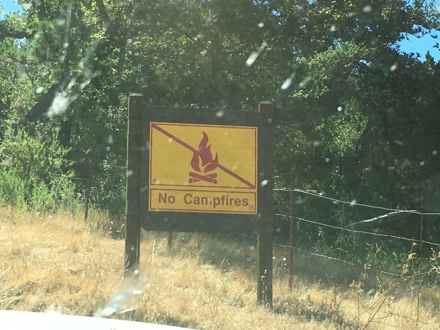
On the South Coast of Big Sur, one campfire may have started a wildfire on Nacimiento Rd. last week, although the cause of the fire is still under investigation. And Sunday, I found a group of campers having a campfire in the middle of an open dry, grassy field disregarding a large no campfire sign they had passed only about 100 yards before the place they chose to camp.

In only 3 days, we will experience the anniversary of the start of the Basin Fire. June 22, 2008, a series of lightning strikes started several wildfires which became the Basin Fire. People, particularly visitors, were able to evacuate in three directions, north, south, and east. This summer that is not true.

Businesses and Chambers of Commerce all up and down the Central Coast are pushing to allow visitors into the areas of Big Sur that are cut off with the only escape routes being a long and difficult pedestrian only trail from the TapHouse to the State Park, or a very narrow, windy mountainous road over the Santa Lucia’s to the east.

Personally, I am concerned about the advisability of this short-sighted solution given the fire conditions we currently have before the end of June, and what is surely ahead. More people mean we increase the chance of man created wildfire, as well as complicate in dangerous ways any need to evacuate tourists and residents. We are facing potentially, the perfect storm of conditions ripe for a wild fire. Grasses are tall due to the rainy winter, they are dried out, the heat wave has been and will be ongoing. I hope there will be no need to evacuate by any of us, but if there is, can we minimize the danger to those of us trapped between the bridge and Mud Creek? Or will we be facing a massive traffic exodus on a road not designed for that purpose? How will emergency vehicles get here, if the road is filled with fleeing visitors? I think these are serious questions we all need to address, particularly our federal, state, and local representatives and agencies.

IMG_2830

There are lessons to be learned from what is happening in Portugal. I hope we can learn them in time.


Campers with Campfire

Sunday morning, I went down the mountain to the coast to get my mail and saw people having a campfire. I didn’t think to get a photo of the campfire as I was completely flummoxed. I did report them to the USFS, as I found several at the station. So, on the way home, glad to see the campfire was out, I got photos.

IMG_1575

They drove by this sign just about 100 yards before the area where they made camp. (Sorry for the dirty windshield, but that’s what happens out here.)

IMG_1576

These were the two vehicles. Look at all that dry grass.

IMG_1577

This shows their tents, the wood they had gathered for their fire, in the branch out in front of the orange ten, and the campfire was right on the other side of that large log, dragged out presumably to sit on. Again, note all that dry grass around their campsite.

IMG_1578

This shows a whole lot of trash, which to their credit they did pack up and take with them, I am told. The two guys are watching me photograph them, and the two gals are to the right of them, shown in the next photo. Again, lots of dry grass.

IMG_1579

Not wanting to be photographed, it would appear. Now these campers were polite and did put out their fire when I pointed out the error of their ways, and they did clean up their trash. But I still can’t understand why they felt it was okay to have a campfire when it was so hot and they were camped in the grass – regardless of the sign. I vow to have a dialogue the next time so I can understand the mentality, and maybe find a way to change that.

Fire Restriction in LPNF

Issued late Wednesday afternoon.

IMG_2809

I suggest locals print out a copy of this (or more for distribution) and carrying them with you. Highlight the $5,0000 fine. Also you might wish to make it a habit of taking photographs of the vehicles camped along the side of the road, particularly on Nacimiento, making sure the license plate is visible. Make sure your camera and/or phone are set to date stamp these (either in Metadata or on the photo itself) and keep these for a couple weeks before dumping them, just in case they are needed. Let’s all hope for a safe and quiet summer.

Might want to print and carry this, too:

IMG_2815


Fire on Nacimiento Rd – fire named Fergusson.

UPDATE 11 am – fire is pretty much out. Aircraft released and back to Paso. Here are a trio of photos from one of the firefighters, Brandi Plaskett (yup, one of those descendants)

IMG_2741IMG_2742IMG_2743

From Rohana. Em called 911, I called the PV Station direct and spoke to a “live” person. This is on Nacimiento Rd. At approximately mm 4. Make sure and scroll for most up-to-date info.

IMG_2731


New pic just taken. It is clearly backing down the ridge in a south-westerly direction.

IMG_2732

Oh, this ought to play havoc with that massive convoy of trucks, supplies, and equipment today for the bridge.

At 9:27 am –

IMG_2733

Okay, ladies and gents, anytime now would be good.

9:35 am –

IMG_2735

Now would be a good time to send in those tankers.

9:41 USFS engine on site and flight tracker showing spotter plane over Lake Nacimiento:

IMG_2736

LPF resources are just coming on for the day, responding as they get the crews together.
Divs 1
BC 11
Crew 3
E15, 16, 319, 31
PAT 17, 18

BEU dispatched
Dozer 4641

May be running part of this on BEU.
AA on scene. 5 acres

MoCo sending resources

From WildCAD:

Nacimiento Update 1

Lead plane laying down smoke on site, T12 in Paso filling up:

IMG_2738

At 10:52 am –

IC is staging the Dozer for the time being.
I think they are probably making good progress, its all in the grass.
Additionally Tanker 12 has been canceled.

Grass Fire at FHL

Grass fire at the firing ranges today. Expect smoke due to the wetness of the grass. Firefighters on scene and conducting back burns to contain fire. Approx. 1,100 acres burned.

IMG_2699