Dolan Fire, Day 23, 9/9/20

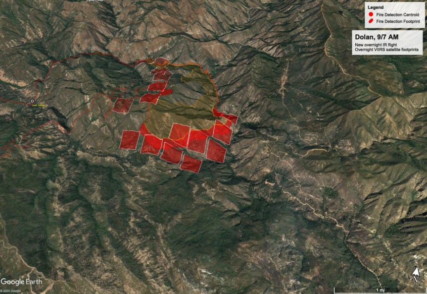
Here is the morning update, the recent USFS map and John Chesnut’s maps; one up top here, and one at the bottom. Of this top map, John says:

“I got the VIIRS points from another, still operating server, but these lump all 24 hour points together, so the dots include both this morning and yesterday afternoon.
Does indicate the fire is established had backing into the Mill Creek heavy timber.” I have heard from another source about a firing out operation in the Mill Creek area that is going well. No further details.

Dolan Fire 

Los Padres National Forest

Public Information Phone: 831-272-0222 

Media Information Phone: 831-272-0221 

Incident E-mail: 2020.Dolan@firenet.gov 

Incident Website: inciweb.nwcg.gov/incident/7018

Dolan Fire
Sept 9, 2020
Rob Allen, Incident Commander
Fire Information: 831-272-0222 Email: 2020.Dolan@firenet.gov
Media Information: 831-272-0221 Inciweb: https://inciweb.nwcg.gov/incident/7018 Facebook: https://www.facebook.com/lospadresnationalforest
Size: 93,554 acres Containment: 20% Personnel: 738 Start Date: Aug. 18, 2020 Cause: Under Investigation
YESTERDAY’S ACTIVITIES: A fire shelter deployment of 14 firefighters occurred in the vicinity of the Naciemiento Guard Station injuring three, one critically. The injured firefighters were transported by helicopter to the hospital in Fresno for treatment. All three firefighters are reported to be in stable condition. The fire burned very actively from the afternoon through the entire evening on the eastern and southern edges.
TODAY’S ACTIVITIES: Winds will shift from the north to the south/southwest as a marine layer spreads over the fire area brining cooler temperatures and higher relative humidity levels to lower evaluations. Above the marine layer steep terrain, dry fuels and strong winds may impact fire behavior burning pockets of fuels, and short uphill runs are expected. Crews along the eastern perimeter will scout out along Kern Ridge to establish line and protect structures. Firefighters will scout out and identify possible opportunities for containment lines utilizing the 2008 Indian Fire burn scar. If weather permits burn operations will happen on the southern and eastern perimeter of the fire. Crews will continue to hold and improve existing lines in the northern perimeter. Structure protection continues in all affected communities. The fire will continue to burn actively to the south and rapid rates of spread can be expected especially in areas where drainages are aligned with the winds above the marine layer.
EVACUATIONS: The Monterey County Sheriff’s has Mandatory evacuation orders for Lucia Zone B and Prewitt Ridge Zone J; Memorial Park FS Summer homes; Zone K South Coastal Ridge Road; Zone L Gorda. Evacuation warning in Zone 27. Advisory evacuation status are in effect in zone 24 east of Arroyo Seco Road; Zone M Salmon Creek Falls. View the interactive map on the Monterey Office of Emergency Services website for Monterey County evacuations.
ROAD CLOSURE: HWY 1 is closed from north of Vista Point south to Pacific Valley. Nacimiento-Ferguson Rd Is closed to all traffic from Highway 1 to the Fort Hunter Liggett base boundary line. Los Burros Road, Plaskett Ridge Road, South Coast Ridge Road are closed except to residents. Visit https://roads.dot.ca.gov/
FOREST CLOSURE: Forest Order Number 05-07-51-20-20 remains in effect on the Forest in the vicinity of the fire.
WEATHER: Winds will shift from the north to the south southwest with possible gusts up to 30mph impacting fire behavior through approximately 1pm. A cooler marine layer will affect the fire below 1,000ft in elevation. Areas above the layer will see higher temperatures and Increasing winds. Fire behavior is expected to moderate this afternoon as winds die down.
SAFETY: Drones should not be flown when an active fire is present. Drones can impede aircraft operations. When you fly, we can’t! Firefighters are still actively using HWY 1 as a major access point to the fire. Falling rocks and debris continues to be a hazard. Most notably in the area of MP 35 on HWY 1.

Dolan Fire Photos, 9/8/20

My son took these over from Prewitt Ridge, I think he said, before he came back and said, “Mom, let’s start evacuating. Let’s get your Sprinter down the hill. I’ll follow you and bring you back, and then we can get anything else, and get your truck and you can leave whenever you want.” He was wonderful…calm, organized, and helpful. Made it so much easier on me.

Warning. These photos are distressing.

Evening Update, Dolan Fire, 9/8/20

First off, for all the many kind offers of somewhere to stay. To get north I would have to come through Paso Robles anyway, and I am just too tired to even think of going further. I really appreciate the offers. I am settled in tonight and tomorrow at an RV park in Paso Robles that Rock Knocker and I have used many times before. He evacuated and went and got his RV and I met him here in my Sprinter. Lady is having a new adventure and she’s just not sure about this motorhome, yet.

The news of the firefighters, the Nacimiento Station saddens me greatly. Two of the firefighter, the one who is critical and the one who is serious I know well. I pray for them tonight, and for the others who lives through the experience with them.

I heard stories and saw neighbors as they came through or we met on the road. Vehicles loaded with pets, possessions, and the pieces of our lives. We all hope to have homes to come home, too. I will write more tomorrow, but tonight I am too drained to think. I teeter tottered between numbness from shock and feeling like I might break down in tears. I was driving. Can’t do that. So maybe tonight I’ll take a few minutes to grieve tor the destruction of the land and the critters I have lived with for 33 years, 26 of them up here.

In the meantime, here is the John Chesnut map. Not everything would load, and he suspects overload of the system. Tomorrow, at a reasonable time…I might get to sleep in.

Evacuation Order

I will be unavailable for a while. I am preparing to evacuate.

Notifications can be found here.

Effectively immediately an Evacuation WARNING is now in place for Zone M – Salmon Creek. The evacuation Order area for Zone M is as follows:

Highway 1@Salmon Creek Falls (Mile Post 2) south to the Monterey County Line. Highway 1 west to the Pacific Ocean. Highway 1 East to Salmon creek Rd (including all roads and tributaries contained within)

Effectively immediately an Evacuation ORDER is now in place for Zone L – Gorda.  Leave the area immediately. The evacuation Order area for Zone L is as follows: 

Highway 1 at Los Burros Road to Salmon Creek Falls (Mile post 2) including all roads and tributaries contained within.  West of Highway 1 to the Pacific Ocean. East of Highway 1 to South Coast Ridge Road.

Effective immediately an UPGRADED evacuation ORDER is now in place for South Coast Ridge Road Zone K. Leave the area immediately. The evacuation ORDER area for Zone K is as follows:  

Area bounded by Hwy 1 at about Mile Marker 15, East to intersection of Prewitt Creek Ridge Road and South Coast Ridge Road, South along South Coast Ridge Road to intersection of Los Burros Road and South Coast Ridge Road, west along Los Burros Road to Hwy 1 near Mile Marker 11, to include Plasket Ridge Road, San Martin Top, and Alder Creek Road.

Evacuation Map is here.

Evacuation Map ss of 2PM:

Dolan Fire, Day 22, 9/8/20

Effective immediately an UPGRADED evacuation ORDER is now in place for South Coast Ridge Road Zone K. Leave the area immediately. The evacuation ORDER area for Zone K is as follows:  

Area bounded by Hwy 1 at about Mile Marker 15, East to intersection of Prewitt Creek Ridge Road and South Coast Ridge Road, South along South Coast Ridge Road to intersection of Los Burros Road and South Coast Ridge Road, west along Los Burros Road to Hwy 1 near Mile Marker 11, to include Plasket Ridge Road, San Martin Top, and Alder Creek Road.

***********************************************************************

New update coming soon, but for now Dolan has expanded to 73, 089 acres.

Before I get to the bad news, here is a lovely morning shot sent to me by Linda Sonrisa Jones. It is much appreciated down here where I am smoked in. It is so dark, I had to turn a light on.

And now for the bad news. We all saw it last night. We watched the Dolan fire dragon wake up and spread its wings all over Big Sur. I got fire photos from many different points of view. But John Chesnut’s heat map really tells the story. Be ready for plenty of new evac warnings and orders today.

USFS Closes So Cal National Forests

Forest Service Temporarily Closes Southern California National Forests,

Adds Prohibitions in Others

VALLEJO, Calif., September 7, 2020 – Most of California remains under the threat of unprecedented and dangerous fire conditions with a combination of extreme heat, significant wind events, dry conditions, and firefighting resources that are stretched to the limit. Due to these conditions, the USDA Forest Service Pacific Southwest Region is announcing the following temporary closures and fire restrictions to provide for public safety and reduce the potential for human caused fire starts. They will go into effect at 5:00 pm Pacific Standard Time on Monday, September 7, 2020, and will be re-evaluated daily as conditions change.

1.       Closure of the following National Forests: Stanislaus National Forest, Sierra National Forest, Sequoia National Forest, Inyo National Forest, Los Padres National Forest, Angeles National Forest, San Bernardino National Forest, and Cleveland National Forest.

2.       Prohibition of the use of any ignition source on all National Forest System lands (campfires, gas stoves, etc.) throughout California.

3.       Closure of all developed campgrounds and day-use sites on National Forests in California.

“The wildfire situation throughout California is dangerous and must be taken seriously. Existing fires are displaying extreme fire behavior, new fire starts are likely, weather conditions are worsening, and we simply do not have enough resources to fully fight and contain every fire,” said Randy Moore, Regional Forester for the USDA Forest Service Pacific Southwest Region. “We are bringing every resource to bear nationally and internationally to fight these fires, but until conditions improve, and we are confident that National Forest visitors can recreate safely, the priority is always to protect the public and our firefighters. With these extreme conditions, these temporary actions will help us do both.”

An example of extreme fire behavior is the Creek Fire on the Sierra National Forest which began on Friday Sep. 4th and grew rapidly on Saturday, Sep. 5th. The fire made a 15-mile run in a single day and burned 36,000 acres, prompting evacuations and life saving measures. The California National Guard evacuated at least 200 people from Wagner Mammoth Pool Campground and assessed them for medical needs.

The Forest Service thanks our partners and the public for their cooperation and understanding of this monumental fire threat. It is critical that all Californians and national forest visitors follow these important closures and restrictions for their own safety and the safety of our firefighters.

The Forest Service manages 18 National Forests in the Pacific Southwest Region, which encompasses over 20 million acres across California, and assists forest landowners in California, Hawaii and the U.S. Affiliated Pacific Islands. National forests supply 50 percent of the water in California and form the watershed of most major aqueducts and more than 2,400 reservoirs throughout the state. For more information, visit www.fs.usda.gov/R5.

Dolan Fire, Day 21, 9/7/20

Last Photos of the daylight hours:

And from the other side at Nepenthe by Sander Koning

John Chesnut Evening map:

From MoCo OES:

Effective immediately for the Dolan Fire an evacuation warning is in place for the ZONE 24. Access is permitted only for residents due to fire equipment and emergency personnel in the area. The evacuation warning area for ZONE 24 is as follows: Areas west of Reliz Canyon Road to the intersection of Arroyo Seco Road. South of Arroyo Seco Road to the intersection of Santa Lucia Trail. East of Santa Lucia Trail to the intersection of Bear Mtn. Trail (21S02). North of Bear Mtn Trail (21S02) to the intersection of Reliz Canyon Road.   

Here are a couple of photos just taken at 4:25 pm

Firefighters of the #DolanFire plan to begin firing operations this morning on a section of fireline that runs from the near Hermitage to US Highway 1. That means you can expect to see more smoke being produced in that area today. “Burnouts“ as they are called, strengthen the fireline by removing fuel between the line and the advancing wildfire. This creates how much wider a buffer than just a bulldozer line or hand line. Burnouts our carefully planned and executed. This is being done to prevent the Dolan Fire from spreading further south in that area and to protect the structures in that area.

In this video, Operation section chief Reggie Bray talks about fire growth overnight and some of the other activities around the different parts of the fire.

For more information visit: https://inciweb.nwcg.gov/incident/7018/

************************************************************************

Monterey County Sheriff’s Office
Monterey County Office of Emergency Services

Information: 831-272-0222                  Email: 2020.Dolan@firenet.gov 

Media Information: 831-272-0221             Inciwebhttps://inciweb.nwcg.gov/incident/7018 

Facebook: https://www.facebook.com/lospadresnationalforest 

Size: 36,237 acres     Containment: 40%      Personnel: 883     Start Date: August 18, 2020       Cause: Under Investigation 

YESTERDAY’S ACTIVITIES: As expected fire activity increased on the eastern and southern edges with Cone Peak seeing the most aggressive spread. Record heat and dry conditions continued to play a major role in fire spread. Occasional uphill runs were observed at higher elevations throughout the evening. Structure and asset protection remain priority one for firefighters.  

Overnight firefighters monitored HWY 1 for any potential hotspots and rollouts with CalTrans support on cleanup of any fallen debris. Overnight lows were in the high 80’s to lower 90’s with poor relative humidity recovery.  

TODAY’S ACTIVITIES: Record breaking temperatures will continue throughout the day and into the evening increasing fire activity. Firefighters along with support from a dozer team continue line construction in the Arroyo Seco drainage and Avila Ranch area reinforcing structure protection. Crews continue improvement of containment lines along McWay Ridge and within the Lucia and Hermitage areas. Several teams are completing the primary containment line north of the Nacimiento-Ferguson Road and along the road to Cone Peak. This indirect line will serve as the primary containment line intended to keep the fire from spreading south toward nearby structures. If conditions allow a planned burnout operation will be used in the next few days to tie containment lines into the fire’s edge. Dozers, hand crews and masticators are also working on additional contingency lines farther south. Helicopters will be available to support ground crews but will be limited due to weather conditions. Structure protection all along HWY 1, in the Partington area north, and in the Lucia and Hermitage areas to the south continues. 

Currently in the fire there are: 6 Type 1 Hotshot crews, 10 Type 2 hand crews, 49 engines, 6 dozers, 13 helicopters, 19 water tenders, 4 masticators and a variety of other equipment to support firefighting efforts. 

EVACUATIONS: The Monterey County Sherriff’s office has an Evacuation Order in effect for Zone B (Lucia) and Zone J (Prewitt Ridge). Warning are in effect for Zone C (Partington) and Zones K-S (Coast Ridge Road). Yesterday, Zone A was downgraded to a warning. View the interactive map for Monterey County evacuations. 

ROAD CLOSURE:  HWY 1 is closed from north of Vista Point south to Pacific Valley.  Visit https://roads.dot.ca.gov/ 

FOREST CLOSURE:  Forest Order Number 05-07-51-20-19 remains in effect on the Forest in the vicinity of the fire. 

WEATHER: Record breaking temperatures continue into the next few days with little relief in sight. Temperatures are in the 90’s along the coast and may reach record breaking degrees again inland. Lower relative humidity across the area are expected throughout the day. Winds are forecast to remain mild.  

SAFETY:  Firefighters are still actively using HWY 1 as a major access point to the fire. Caution is stressed as emergency vehicles are entering and exiting the highway at all times of the day. Falling rocks and debris continues to be a hazard. Most notably in the area of MP 35 on HWY 1. 

### 

Dolan Fire 

Los Padres National Forest

Public Information Phone: 831-272-0222 

Media Information Phone: 831-272-0221 

Incident E-mail: 2020.Dolan@firenet.gov 

Incident Website: inciweb.nwcg.gov/incident/7018

************************************************************************

Here are John Chesnut’s heat maps, and potential contingency line:

Proposed new contingency line on the east side of the fire.

And here is a photo I took late last night; on the south side of Cone Peak to be visible from my place.

Dolan Fire Photos, 9/6/20

I am going to start with one I took last night.

Here are a couple from this morning that I posted on the daily update post:

Here is Scott Haley’s from Chew’s Ridge

And here are the ones from about 11-12 today

And this is a new containment line.

Dolan Fire, Day 20, 9/6/20

And here we have John Chesnut’s evening map.

And luck would have it, we have a view from the other side, thanks to Scott Healy, Chew’s Ridge Lookout, also from this am;

Let me start off by apologizing for being so late to post. My puppy did a rare thing and let me sleep until 8, so just catching up on where we are today. This is what it looks like this morning:

9/6 8:30 am
Zoom in on Cone Peak, 9/6/20, 8:30 am

That’s what it looks like from my window this am. Here is the public information map by USFS

And now for John Chesnut’s heat detection maps:

Best photo of the Dolan Fire to date

This photo was taken by Michael Peckman, a friend of Brandie Kirby Grondin, who is driving this Cal Trans truck. Want to know why Highway One has been closed? Maybe this might help you understand…. (I have permission from both to post this.)