Carmel (Day 4) and River (Day 6) are combined into one post at the moment. Please click the title of the post to open a separate window, and refresh the page as the post will be updated throughout the day.
Carmel Incident Update:


River Incident Update:


3:39 PM: EVACUATION WARNING FOR ALL OF CARMEL VALLEY VILLAGE TO LAURELES GRADE
Evacuation Notifications can be found here
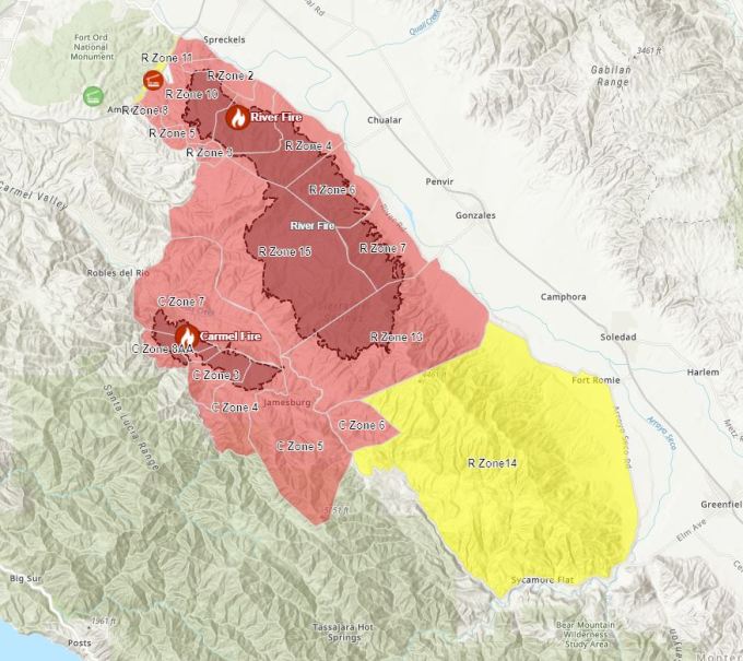
Evacuation Map can be found here (Red is Order, Yellow is Warning)
(click the image to open the map, Yellow is warning, Red is Evacuation Order, map is subject to change at any time)

The Monterey County Sheriff’s Office has issued an Evacuation Warning for all areas East of Carmel Valley Road, North to Laureless Grade, East of Laureless Grade to Highway 68 to include areas West of San Benancio Road and the Corral de Tierra community.
Zone 17: All areas south of Highway 68 from San Benancio Road to Laureles Grade. To include all roads east of Laureles Grade at La Rancheria Rd to the south, and all areas west of San Benancio Road. EVACUATION WARNING
Zone 18: We are extending the evacuation warning west on Carmel Valley road from Klondike Canyon Road to Laureles Grade, North on Laureles Grade from Carmel Valley Road to La Rancheria. This warning includes all communities North East of Carmel Valley Road, and all communities East of Laureles Grade to include Carmel Valley Road, Laureles Grade, La Rancheria and all tributary roads. EVACUATION WARNING
The Monterey County Sheriff’s Office has issued an Evacuation Warning for areas west of Carmel Valley Road from Klondike Canyon Road to Pine Tree Lane extending south to Dormody Road and east to Hitchcock Canyon Road and San Clemente Drive. This Warning includes all communities on Carmel Valley Road and all communities south west of Carmel Valley Road between Klondike Canyon and Pine Tree Lane, including Carmel Valley Village, Robles Del Rio.
Weather Watch in effect from Sunday morning through Tuesday morning.
* AFFECTED AREA…Entire San Francisco Bay Area and Central Coast. Areas of highest concern will be included in future updates.
* WIND…Generally light onshore winds. However, erratic gusty winds 40 to 65 mph may accompany stronger thunderstorms.
* THUNDERSTORMS…Isolated to scattered dry thunderstorms will develop Sunday afternoon and into Monday morning. An additional round of thunderstorms are expected to arrive later Monday into Tuesday. Dry thunderstorms may become wet as the event progresses.
* IMPACTS…Lightning will likely spark new fires across the region, including remote areas. Wildfires in remote regions may not become apparent until warmer and drier conditions allow them to grow. Please report potential fires to local CALFIRE or
SHERIFF offices. Listen for later forecasts and possible Red Flag Warnings.


7:00 AM: Carmel and River Fires Google Earth Image with VIIRS and MODIS Satellite and CDF Infrared Outline (from 08/19/20). Some of the latest satellite detections are 3:30 AM PT. Click this link to view larger image: Carmel_River_Fire_082120

Toro View: Carmel_River_Fire_Toro_082120

Palo Escrito View: Carmel_River_Fire_Escrito_082120

Tassajara Road View: Carmel_River_Fire_Tassajara_082120

Sleepy Hollow View: Carmel_River_Fire_Sleepy_082120

Carmel Incident Update:


River Incident Update:


Office of Emergency Services response page here
Quick reference of key resources to stay up-to-date here
National interagency Fire Center Map can be found here
Current Wind can be found (please confirm time) here
Alert Wildfire Camera here
Air Traffic here
Road Closures here
CalFire’s Ready, Set, Go! Checklist here (see page 9)