Thank you, Susana, this is very thoughtful and informative. I, for one, really appreciate it.
Good morning everyone,
Our noontime update for all Hwy. 1 is coming; however, this is a much lengthier explanation from Geotech/Maintenance Design for you as locals…that may “see” the roadway better than it actually is.
From the south, then:
PM 8.9 is very rough. The pavement has heaved up like very large speed bumps, at three distinct spots. This will be a challenge for any low riding vehicles. This location has only dirt haul work going on today into early next week when we will have a driller on site taking up one lane, under one way traffic, controlled by flaggers. Keeping in mind that if it is raining, we will not be on site. Also, possibly middle of next week, pipe culvert materials may be arriving for replacing the two failed culverts at the southerly end of Mud Creek landslide. This will require excavation of what could be a rocky fill to get to the old culverts. They are about 8 feet deep, but the possibility for rocks in the fill might make it difficult to span the excavation with steel plates and allow for vehicle passages during these 2-day operations (for each cross culvert). Again, we do not yet have these culvert pipes on site yet and they could be arriving later than next week, so we will keep you posted on that. Drilling is expected to take 6 days, once it begins and weather permitting. They have delayed their start a couple of times and as of my latest info, we are expecting them to being Tuesday, 7Feb2016
PM 14.4, Culvert replacement JNO Sand Dollar is starting today. This too is a shallow culvert and we expect to be done here by the end of this week, weather permitting. Flagging is protecting the work here and steel plates are on site to allow for vehicles to go through. If all goes well, this should be a three day operation.
PM 21.6, Paul’s slide has only one lane available to traffic. We are supposed to have one way traffic controlled by flaggers today and each day the crews are working. The dirt haul from Mud Creek is to Willow ck. and I believe they are also moving spoils from Paul’s slide to willow ck., too.
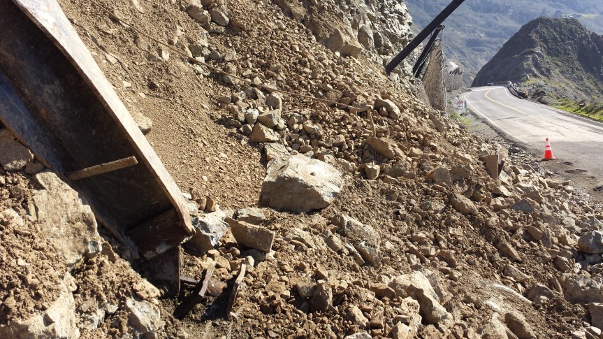
PM 28.3, Cow Cliff has a large hole in the rock fall netting. The pavement has been repaired and most of the slide material has been moved off of the surface of the travel way, so the road appears to be open. However, with the netting down and more weather coming, we are offering no assurances that more rocks and material will not come down onto the road. There is hard closure at Dolan Pt. (for southbound traffic) and Maintenance is supposed to have placed one at the Big Creek Bridge (for the northbound). To clarify our delay in starting work here, the chute above the damaged netting cannot be scaled, as we’ve done at other sites. It is outside of what would be considered okay for worker safety. The materials for this repair are being ordered now and this highly technical installation will begin as soon as materials begin arriving. The contractor is standing by.
On last reminder, if it is raining we will not be on site. There is too much unstable material above and below the roadway at mud creek and at Paul’s slide. The road will be closed during rain from Ragged Pt. (SLO 72.87) to Dolan Pt. (PM 29.7)
Susana Z. Cruz nature-flower-blue-motif[1]
Caltrans District 5
Acting Manager
Public Information Office