

Photos by J.R. Carmichael yesterday, 8/21/17 around 1:30 pm –


And here are some from Kyle Evans taken this morning, Tuesday:


Photos by J.R. Carmichael yesterday, 8/21/17 around 1:30 pm –
And here are some from Kyle Evans taken this morning, Tuesday:
Photos of Pfeiffer Canyon Bridge (PM 45.52) showing the final girder assembly and the launch nose and bridge deck prep work. Photo of Mud Creek in 1995—Courtesy of Rock Knocker.
HIGHWAY 1 UPDATE – Monday, August 21:
Highway 1 in Monterey County continues to provide 35 total miles of Hwy. 1 to the public from south of Gorda (PM 10) to just south of Pfeiffer Canyon (PM 45.5), accessible only via Nacimiento-Fergusson Road. State Route 1 remains closed from north of Salmon (just south of the Ranger Station (PM 3) to just south of Gorda (PM 10) due to the Mud Creek event. State Route 1 south of Salmon Creek is accessible via State Route 1 in San Luis Obispo County, past Ragged Point to Salmon Creek.
REMINDER: Travelers CANNOT travel the entire length of Highway 1, but local businesses are open on both sides of the closure points at Pfeiffer Canyon and Salmon Creek.
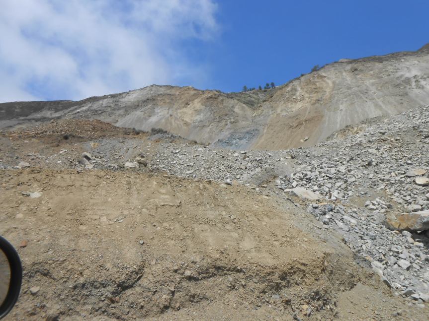
Mud Creek (PM 8.9)
Mud Creek had a major slide on Saturday, May 20, 2017, losing 5 million cubic yards of material. Caltrans continues with its plan to realign the existing terrain. A tentative cost and timeline is targeted to be announced at the end of August. The roadway remains impassable.
There is no public access through the Mud Creek area as this is an active construction zone.
Paul’s Slide (PM 21.6)
Paul’s Slide continues to provide access to the public 24/7, with one-way reversing traffic control with flaggers.
Pfeiffer Canyon Bridge [PCB] (PM 45.52)
· The girder assembly has taken place in preparation for the bridge launching over the canyon, expected to take place this week.
· Public access is still on schedule for mid-to-late September.
Caltrans reminds motorists to move over and slow down when driving through highway work zones.
For more information on this project and for traffic updates on other Caltrans projects in Monterey County, residents can call the District 5 toll free number at 1-831-423-0396 or can visit our website at: http://www.dot.ca.gov/dist05/paffairs/release.htm#mon
Susana Z. Cruz
Caltrans District 5
Public Information Officer


Per KSBW at 10:30 am:
BIG SUR, Calif. — A massive search is underway for a fisherman who was knocked off rocks into the ocean by a large wave near Garrapata State Park in Big Sur Sunday night.
Lifeguards from California State Parks and rescue swimmers are searching kelp beds for the missing angler.
Martha Diehl reported many law enforcement present at the Crab Lab when she drove by earlier this am.


Benteley from Michigan, photos by Rob Wilks. I have been hearing horror stories re traffic on the Peninsula. Have one you want to share? Do so in the comments below.


New hours at the Big Sur Library!
Starting September 2nd 2017, the hours will be changing on Fridays and Saturdays only from 11-4 to NOW 10-3. Hours will remain the same on Wednesdays and Thursdays. Also, schedule changes regarding meetings and clubs will have to be updated accordingly, and those affected will be notified.
As always, please do not hesitate to call with questions or concerns. J
Sincerely,
Julia Mazerik
Big Sur Library Branch Manager
Monterey County Free Libraries
Hwy 1 at Ripplewood Resort
831 667-2537

These were taken yesterday, 8/14/17, by Rock Knocker, who was escorted to the work area by Wayne Walker, the project manager. First, let me put to rest all the recent rumors people have been asking me about. No, Mud Creek is NOT going to open at the same time as the bridge, and NO, it is not going to open to locals only anytime soon. As has been said numerous times before, the timeline for the completion of this project is expected to be released by month’s end. Evaluation and prep work are still being done as of now.
First off, here is a recent aerial view to provide some perspective as to what one is seeing in the closer, on-the-ground photos:

Here are 15 of the ones Rock Knocker took yesterday, then I have added two historical ones.

That is the rock sea wall being built. It will come north to that “mound” just behind the pompas grass.

On can see the containers up on the left which are going to be used as a retaining wall.

Hauling in and moving rock


This first one is from 1995:

And this one is from 1994. I am told I already published this one, but worth repeating.

From Marcus Foster:

First off, let me thank and congratulate the USFS and the MCSO. There were NO campers late Saturday morning in ANY turnout on Nacimiento Road. We saw only this one tent, well off the road, and the corresponding car in a small dirt turn out. Rock Knocker thinks it was within the 300 ft. Limit, but I’m not so sure.

Before we got to this point, there was a truck pulling a travel trailer that stopped in the middle of Nacimiento Rd. Just befor the Ranger Station on the east side of Nacimiento. He was fixing his chain, his lights, his trailer brakes or something. To his credit, he did stop by a turn out that allowed others to get by – barely on his read end, but all but large trucks could get by.

And then, up Plaskett – a large group camping at Turkey Flats who were putting out a campfire at 11:50 am. We stopped and told them of the $5000 fine, and they laughed and continued drinking their beer. Note the shovel in the guy’s hands.

And the open beer cans on the log

And the case of beer for later

Rock Knocker got photos of all the license plate numbers, since they were on his side.
I called PV Station and sent emails to my USFS neighbors. They will be having another campfire tonight unless they are stopped and cited, which I am hoping they will be.
Los Padres Prohibits Camping Along Nacimiento-Fergusson Road
GOLETA, Calif., August 11, 2017– Los Padres National Forest officials today announced that dispersed camping along the Nacimiento-Fergusson Road (Forest Road No. 22S01) on the Monterey Ranger District is prohibited under a new Forest Order. This prohibition is effective immediately, and will be strictly enforced due to public health and safety concerns.
This Forest Order will remain in effect through August 10, 2018, and violations of the Order are punishable by a fine of $5,000 and/or six months in jail.
The recent closures on State Highway 1 due to storm-related slides, along with the failure of the Pfeiffer Canyon Bridge, have led to concentrated public camping use along Nacimiento-Fergusson Road. The volume of dispersed, roadside camping along the Nacimiento-Fergusson Road has significantly increased to the point where the public are placing tents and recreational vehicles in pull-outs designed for vehicles to allow oncoming traffic to safely pass. Visitors will often use their vehicles to protect their sites at night, which partially obstructs the roadway, causing traffic and camping conflicts and related public safety concerns.
The Forest Order extends along the right-of-way of Nacimiento-Fergusson Road from State Highway 1 west to mile post 10.3. Dispersed camping is prohibited within a 300-foot buffer that extends from the road’s center line.
Visitors are reminded that Los Padres is currently in Level III fire restrictions, under which recreational target shooting and dispersed campfires outside of established campgrounds are not permitted.
For more information, please contact the Monterey District Office at (831) 385-5434.