
The traveling public making it difficult for Cal Trans to keep up with road work. Photos by Brendon Shave.


The traveling public making it difficult for Cal Trans to keep up with road work. Photos by Brendon Shave.
At 11:30 am I received this email:
“Just back from walking dogs @ Rocky Creek. Incident jno mm60 (which is just north of the new Rocky Creek viaduct) is entirely cleared. It looks to have been some stray branches from the Westmere cypress trees.” (Martha Diehl)
6:00 am – just got word from a local (sent t 12:30 am, but just received) that Nacimiento is closed due to slides.
As of 5:30 am the CHP website lists 3 areas of concern. (Try as I might, I can’t seem to copy and paste). From South to North they are: MM 26, 34, and 60. MM 26 is Gamboa Point, but the CHP lists it as just north of Limekiln State Park, which is actually closer to MM 20. This one is listed as rocks and boulders and barely enough room for a small car to get through. CHP says there is signage, but not enough. MM 34 is near Esalen’s South Coast Center, and 60 is just South of Palo Colorado Canyon. One of them is a tree that is crossing both lanes, but unclear which. Dawn is still a couple hours away, at which time dawn patrol will be out clearing the way. Until then, be careful, aware, and drive slowly.
11 pm – bedtime. Currently at 1.82″ since midnight. Still raining. Remembered to write down the monthly amount so I can figure out the rain amount for this last hour. Be safe everyone.
Okay, I’ve been taking the day off, but not without checking on things, specifically road conditions. Here is one that won’t affect most of us … It’s on Garrapatos RD.
Incident: 00365 Type: Traffic Hazard Location: 59625 Garrapatos Rd Loc Desc: Lat/Lon: 36.400156 -121.873975
Detail Information
4:39 PM 3 [5] RP HAS PLACED A RR TIE IN THE RDWY
4:38 PM 2 [4] APPRX 200 YDS FRM THE PRVT ROAD
4:36 PM 1 [1] SINK HOLE IN MIDDLE OF RD , DUE TO A CULVERT THAT HAS BEEN UNDERMINED
I have received over an inch since midnight. I forgot to write down the monthly amount so I could figure out later what I received from 8 pm until midnight. Sorry


8:15 am – up to .41″ already. Going to be a fun day!
7:30 am – At 6 am, there was nary a drop of rain. At 7:00 am it was pouring, and that continues. Already up to .20″ No major road conditions on Highway One to report at this time, BUT several mudslides in SLO Co reported, and remember the Big Sur hills are already saturated, so expect difficult conditions to develop. Will continue reports as needed throughout the day.
These are the current conditions: (graphic to be posted when Internet allows)

Per John Lindsey, SLO forecaster: “Rainfall amounts with this system are expected to range between 0.50 and 1.25 inches. Overall, between 1.25 and 2.75 inches of rain is forecast between today into Monday with higher amounts in the Santa Lucia mountains.”
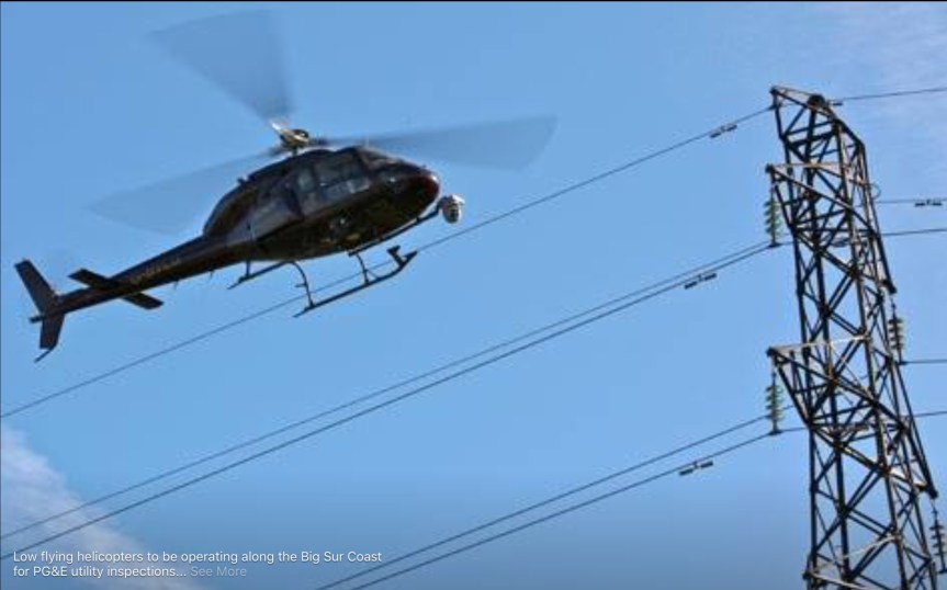
Low flying helicopters to be operating along the Big Sur Coast
for PG&E utility inspections
March 9-12, 8am-5pm
Residents may see or hear helicopters hovering and flying close to the power lines for several minutes at a time throughout the day. The inspections are to observe clearances between vegetation and the power lines so we can ensure we continue to provide safe, reliable, and affordable service. No electric service is expected to be affected by these inspections.
If residents have questions about this work, we encourage you to refer them to the PG&E Customer Outreach Specialist Lizz Williams @ (831) 784-3592. Please note that our work schedule is subject to change and is dependent on safe weather conditions. We appreciate your patience while we complete this important project.
2:45 – ANOTHER BLOCKAGE
Incident: 00054 Type: Traffic Hazard Location: Sr1 / Sycamore Canyon Rd Loc Desc: SR1 JSO PFEIFFER BIG SUR STATE PARK Lat/Lon: 36.240221 -121.777039
Detail Information
2:40 AM 3 [7] 1039 CT DIST 5
2:38 AM 2 [3] BLOCKING ALL OF SB SR1 AND PART OF NB SR1
2:36 AM 1 [1] TREE BLOCKING HWY JSO BIG SUR STATE PARK
2;30 pm – Winds nasty this early am, and rain is pouring. This is a 60′ tree near Esalen’s back gate blocking the road. A SIG alert has been issued. UPDATE – CAL TRANS SUPERVISOR ENROUTE TO ASSESS, WILL BE 1/2 HOUR OR MORE UNTIL ARRIVAL.UPDATE AT 3 AM – TREE CLEARED AND ROAD OPEN AT THIS LOCATION.
From CHP website:
Incident: 00037 Type: Traffic Hazard Location: 54201 Sr1 Loc Desc: SR1 JSO BIG SUR MM 33 Lat/Lon: 36.139275 -121.650808
Detail Information
2:17 AM 10 [21] EMAIL SENT TO CAL TRANS ALSO
2:01 AM 9 [19] 1039 SLO COM CENTER
1:59 AM 8 [18] 1039 MTY COM
1:56 AM 7 [16] 1039 27-S6 UPDATED
1:55 AM 6 [15] PER CAL TRANS , SUPV ENRT TO CHECK AND WILL ADVISE IF ROAD WILL BE CLOSED
1:49 AM 5 [14] PER S6 , CONFIRM CAL TRANS WILL PUT OUT SIGNS NEAR CARMEL TO ADVISE CLOSED
1:47 AM 4 [12] BLOCKING BOTH NB/SB LNS JNO MPM 33
1:47 AM 3 [11] [Notification] [CHP]-PER CAL TRANS DONT RESPOND AT NIGHT MIGHT HAVE TO CLOSE ROAD
1:46 AM 2 [8] 1039 CAL TRANS
1:42 AM 1 [1] LARGE TREE ROOTED UP , 1125
Shortly after I posted this, Maya found her way home. Her humans were so relieved. It was only a few days earlier that they lost Maya’s companion, the 13-year-old dog. Maybe she went looking for her friend … Anyway, enjoy the rain. Storm report later.

Lost Dog (Big Sur near Gorda Mt.)
Our sweet Australian Shepherd/Rottweiler mix female dog went missing today. She is almost 3 years old and her name is Maya. She did not have her collar on but does have a microchip! She was last seen March 6th, Sunday morning near her house on Gorda Mt. (near the Cruickshank Trail), Big Sur. There were a lot of hikers today. We are very worried and really want her back so please help us get her home. Call Tafay or Josh : H:805-927-5674, C: 831-238-0112, C: 831-915-6570, Email: tafay@me.com.
Thank you!!!
