Highway Closure Update, 6/30/17

All previously provided information remains the same, so only including the photos:

Photos of: 1-2) Mud Creek—with new equipment on mid-slope on Tuesday, June 27 3-5) Paul’s Slide (PM 21.6)—Panoramic, busy workday pic and huge boulder yesterday, June 29; 6-7) Pfeiffer Bridge Construction (PM 45.52) temporary tower and welding of temporary tower grillage to aid in the future launching of the new bridge over the canyon—photo from yesterday, June 29.

*NO CONVOY SCHEDULED FOR PFEIFFER CANYON BRIDGE NEXT WEEK (JULY 3-7)*

PM 8.9 Mud Creek-1 6.27.17PM 8.9 Mud Creek-2 6.27.17PM 21.6 Paul's Slide-1 6.29.17PM 21.6 Paul's Slide-2 6.29.17PM 21.6 Paul's Slide 6.29.17PM 45.52 PCB Temporary Tower 6.29.17PM 45.52 PCB Welding Temp. Tower Grillage 6.29.17

CT NEWS FLASH – MUD CREEK

Cal Trans has filmed a very interesting video about Mud Creek that is worth the few minutes of your time. (Nothing new, but a few details and a few visuals, otherwise a fluff piece.)

Mud Creek

Guest Column on Fire Safety

By Barbara Tiberi:

Big Sur Businesses Can’t Do It All

I lived in Big Sur for 20 years, and when we first got there, traffic was insignificant. There were just enough visitors to keep folks in business, and the businesses could handle educating everybody personally about the delicate environment. The balance was perfect. But now it seems askew, there are way too many visitors and the businesses can’t possibly educate all of them, not with the number of inexperienced visitors coming. Everyone is waiting for one mistake to be made by just one “stupid tourist” that starts a fire that puts everyone’s life at risk.

The local businesses can’t be expected to carry the load of educating everybody that comes down the highway just because they’re already trying. They need help. The whole community needs to rally behind them on this, including Monterey County Government, State Parks and Cal-Trans, working with businesses and the great local artist community to come up with solutions for managing this tourist inundation. It’s time. Well, that’s an opinion from an ex-pat who’s worried you’re not doing enough to protect yourselves and your world. I’ve done some educational marketing in a past career, and I’ve included a starter plan/template to think about. I think it’s hard for a large group to come up with a plan, but, if you see a plan, you can instantly see the flaws in it, and a better plan comes to mind. So have at it.

1 – Educate people on the way in – Put up some signs.

When I went to Maui, there were signs everywhere telling me what not to do. There were enough signs to make it clear they valued their environment and wouldn’t take any shit, but it didn’t keep me from seeing the beauty of Maui, and didn’t keep me from wanting to go back.

You guys could pick a few turnouts on each road leading into Big Sur and label them proudly as “Big Sur Information Centers.” Put up some colorful fire-safety signs plus whatever info you decide on to help visitors make the right decisions. Put in some port-a-potties. Folks will stop to use the port-a-potties, and read the signs while waiting in line. You’ll keep the highway cleaner while exposing people to your message. Even illegal campers need to pee, and they especially need to know campfire safety.

You could also have more fire safety signs. The current no campfire signs are invisible. Last I saw, they are the same color as the dry grass and dust they are posted in. No wonder people ignore them. Make them award-winningly attractive, colorful and clear. Make them so fun, people WANT to take pictures of them. Make them so fun, the tourists clean them off themselves so they can get better pictures. You need to have a minimum of 3 signs on each roadway heading in to make an impact. Education requires repetition, and the lesson you need to make clear is a life saving, important message. Don’t skimp. Ask yourself, are you trying to protect the view or the environment, or the lives of the people? I think you have a better chance of doing it all if you exchange some of the view on the highway for better informed visitors. Most visitors want to learn about your environment, that’s why they come.

2- Make the fire-safety information valuable to visitors to have in their possession

Enter people who have taken photos of the fire-safety signs into a contest wherein the winner gets a free weekend in a Big Sur hotel or cabin. Notify the media about the contest and make it a huge deal. Have the contest twice a year for a few years to get the word out. Use the whole “37 pieces of flair.”

Also have fire-safety brochures that include a contest entry form in all the businesses and parks for folks who leave their devices at home. If they have the fire safety info on them while they are in Big Sur, they can enter the contest.

Most people from the urban world don’t have experience with wild environment fire-safety. To them, fire-safety means not getting their candle next to a curtain. The amount of moisture in the fuel load is a different language they don’t need to know about at home. You’ll have to teach them about it to protect your world.

Remember, any time folks are waiting in line, you have a chance to educate them, and government agencies have a responsibility to help you manage and educate the huge numbers of tourists, to reduce wildfire risks and costs for everyone. I’m sure you folks can come up with really great ways to educate your visitors. Only you can make it happen, though. Good Luck with the swarm!

Stay safe.
Enjoy the space.
Thanks for listening.

Big Sur State Park Opening & Highway Closure Map

IMG_2873IMG_2874IMG_2875

Geological “Map” of Mud Creek

Mud Creek Slide Anatomy_V5 (1)

I had to look “Head Scarp” up – Scarps, tension gashes, and lobes are features that identify active or recently active landslides (fig. 2). A scarp is a steep (nearly vertical) region of exposed soil and rock at the head of the landslide where the failure surface ruptures the ground surface. Here is an example:

IMG_2869

I will bring you up-to-date with the Hill Fire later this am.

Slide Repair JSO Rocky Creek starts tomorrow, 6/27/17

Today’s Date: Monday, June 26, 2017
District: 05 – Santa Barbara, San Luis Obispo, Monterey, San Benito and Santa Cruz Counties
Contact: Susana Z Cruz (bilingual) or Colin Jones
Phone: (805) 549-3138 or 549-3189

FOR IMMEDIATE RELEASE

SOUTHBOUND STATE ROUTE 1 SLIDE REPAIR PROJECT JUST SOUTH OF ROCKY CREEK VIADUCT BEGINS TOMORROW

MONTEREY COUNTY – Caltrans will begin a slide repair project on southbound State Route 1 just south of Rocky Creek Viaduct (PM 59.9) tomorrow, Tuesday, June 27, Caltrans officials have announced.

Roadwork will consist of one-way reversing traffic control from 6 am to 6 pm Monday through Thursday and from 6 am to 12 noon on Friday. Roadwork is expected to complete this Friday, June 30, but may resume next Wednesday, July 5 if necessary for the remainder of the week.

The contractor for this slide repair contract is Graniterock of Watsonville. This roadwork is necessary for the safety of the traveling public.

image005

Highway Closure Update, 6/26/17

STATE ROUTE 1 REMAINS FULLY CLOSED IN BOTH DIRECTIONS AT MUD CREEK DUE TO CONTINUED SLIDE ACTIVITY. DELIVERY VEHICLES AND LOCAL RESIDENTS WILL NEED TO USE NACIMIENTO-FERGUSSON TO EXIT SOUTH OR TO CLEAR THE ACCESS TIMES AT PAUL’S SLIDE.

THE INFORMATION BELOW IS FOR LOCAL RESIDENTS AND DELIVERY VEHICLES ONLY;THE ONLY ACCESS TO THE PUBLIC HAS CHANGED AND IS SHOWN BELOW.

Public Access on Highway 1 now at two locations:
1) The closure has moved up five miles to the north from Ragged Point (Slo PM 72.87) to north of Salmon Creek and just south of the Ranger Station (Mon PM 3.0), effective tomorrow, Saturday, June 24.
2) Using Nacimiento-Fergusson, will be to Gorda (PM 10) to the south, and to Limekiln State Park (PM 20.76) to the north.

************************************************************************************************
Mud Creek (PM 8.9) – MUD CREEK HAD A MAJOR SLIDE/SLIP OUT AT 9:30 PM, SATURDAY, MAY 20—IT LOST MILLIONS OF CUBIC YARDS OF MATERIAL. GEOTECHNICAL AND RADAR ASSESSMENTS CONTINUE AT THE SITE AND INCLUDES: FIELD MAPPING, RADAR MONITORING, REVIEW OF USGS PHOTOGRAMMETRIC SURVEY DATA AND BORINGS. IT REMAINS IMPASSABLE UNTIL FURTHER NOTICE.
·
Paul’s Slide (PM 21.6)—CONTINUES WITH USUAL ACCESS SCHEDULE TO LOCAL RESIDENTS/DELIVERIES.

IMPORTANT NOTE: THE ROADWAY THROUGH PAUL’S SLIDE CAN CLOSE DOWN AT ANY TIME WITHOUT PRIOR NOTICE . CALTRANS NEEDS TO CONTINUE RE-ASSESSING THE SITUATION AND DETERMINE WHETHER LOCAL ACCESS CAN REMAIN THROUGH PAUL’S SLIDE.

· 12:00PM Monday / Wednesday / Friday– A single caravan south and a single caravan north, you must be in line by noon! There may be up to 45 minute delay to clear the road before the opening.

· Delivery vehicles (Restriction is 30 feet maximum length and 50,000 lbs. maximum weight) can now use all access windows 7 days a week.

· Access times for the morning and evening are still the same except for Friday:

5:30AM to 6:00AM and 7:00PM to 7:30PM – Sat.-Thurs.

· Friday’s hours will be shortened to:

5:30AM – 8:00AM and 6:00PM to 7:30PM

· The noon opening will be for PAUL’S SLIDE ONLY, (NOT MUD CREEK); you will need to use Nacimiento-Fergusson Road to exit the coast.

The targeted “public access” date is currently mid-July, dependent on roadway conditions and slide activity.

Pfeiffer Canyon Bridge [PCB] (PM 45.52)
· Girders continue to be fabricated in Vallejo, CA and are being sent to Linden, CA (near Stockton) for painting before being trucked over to the Pfeiffer Canyon Bridge construction site.
· Mud Creek assessment progress continues but is closed until further notice. We continue to bring convoys with 10-wheelers containing loads of material: gravel, sand, equipment and other items via convoys through Nacimiento—Fergusson with CHP escorts—the next convoy is yet to be determined.
· Current “Tentative” Timeline as follows:
o On site, the contractor has completed abutment 2 on the north side and continues work to complete abutment 1 on the south side, scheduled to complete mid-July.
o The steel girders will be assembled on site between July 6—July 30.
o Bridge Launch is scheduled between July 31—August 6.
o Deck Construction—schedule to be determined.
o Current public access date remains: Mid-to-late September

Photos of: 1) Mud Creek from North Side—up the slope, Thursday, June 22; 2-3) Paul’s Slide (PM 21.6)—2] Busy workday pic from Saturday, June 24; 3] Bench work at Paul’s Slide Saturday, June 24; 4) Pfeiffer Bridge Construction (PM 45.52) Three more girder segments being shipped to Paint Plant near Stockton this morning, June 26.

PM 8.9 Mud Creek-North Side 6.22.17

PM 21.6 Paul's Slide 6.24.17

PM 21.6 Paul's Slide Bench 6.24.17

PM 45.52 PCB Girder Segments Shipped to Paint Plant 6.26.17

Big Sur Shuttle Service

A new service will be instituted beginning July 1st, which will coincide with the opening of the State Park. The website explains what the service offers. Interestingly, only those utilizing the shuttle, or campers in the State Park, will have access to the TapHouse Trail, which the shuttle service calls the Community Trail. Also the service is providing educational information in the form of pamphlets and story-telling. This could be an interesting experiment on how to minimize some of the impact of the overuse of tourists in our area after the bridge is open. It will have several months of a sort-of “trial” run to see how this works. It could easily be part of the solution, which is always good to hear. Please go to their website to check it out:

Big Sur Shuttle Service

And for current State Park Information, check out this website:

Pfeiffer State Park

Road Closure Update, 6/23/17

Sorry, I am a day late with this, but yesterday I did a town run, and since I was driving, and mostly out of cell range, I couldn’t get this up. In any event, here you go. Also, here is an article about our situation written by a local and friend, Anni Agren, you might find interesting. I already shared it on FB, so will be  a repeat for some of you. The link is below. There is not much (if any) new information in the Cal Trans briefing, but it has been a while since I published the entire thing, so am doing so here. Note, old dates for upcoming convoys, with an update that no convoys are expected for next week. However, at the entrance to FHL from Jolon Rd. I did note a flashing sign indicating an expected truck convoy for 6/27, next Thursday. Whether this was for an expected convoy that has since been canceled or whether it is for one of FHL’s own convoys is undetermined at this time.

Article by Anni Agren

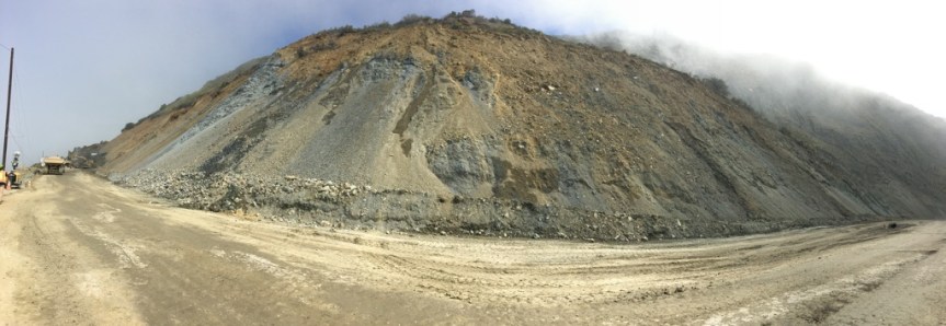
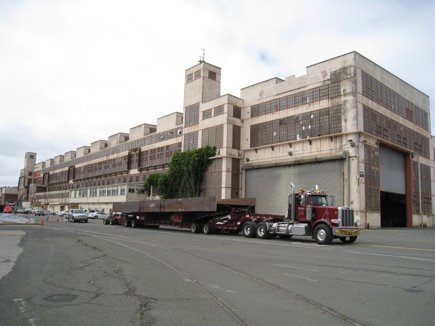
Photos of: 1) Mud Creek from North Side facing South yesterday, 6/22; 2-4) Paul’s Slide (PM 21.6)—2] Video with massive boulder from Tuesday, 6/20; 3] panoramic photo of Paul’s from Tuesday, 6/20 and 4] photo of busy work at Paul’s yesterday; 5) Pfeiffer Canyon Bridge photo from yesterday showing construction of temporary center tower to assist in the future launching of the bridge across canyon and 6) Convoy video from Tuesday, 6/20 containing delivery trucks filled with aggregate and materials to assist in the construction of the new Pfeiffer Canyon Bridge.

*NO CONVOY SCHEDULED FOR PFEIFFER CANYON BRIDGE NEXT WEEK (JUNE 26-30)*

HIGHWAY 1 UPDATE – FRIDAY, JUNE 23:
STATE ROUTE 1 CLOSURE MOVES UP FIVE MILES ON THE SOUTH END FROM RAGGED POINT IN SLO COUNTY TO NORTH OF SALMON CREEK, JUST SOUTH OF THE RANGER STATION (PM 3) IN MON COUNTY EFFECTIVE TOMORROW, SATURDAY, JUNE 24.

PAUL’S SLIDE ON STATE ROUTE 1 CONTINUES WITH USUAL ACCESS SCHEDULE TO LOCAL RESIDENTS/DELIVERIES….WE WILL CONTINUE RE-ASSESSING AND AN UPDATE PROVIDED BY MID-DAY MONDAY, JUNE 26 (See Update under “Paul’s Slide” for more details.)

STATE ROUTE 1 REMAINS FULLY CLOSED IN BOTH DIRECTIONS AT MUD CREEK DUE TO CONTINUED SLIDE ACTIVITY. DELIVERY VEHICLES AND LOCAL RESIDENTS WILL NEED TO USE NACIMIENTO-FERGUSSON TO EXIT SOUTH OR TO CLEAR THE ACCESS TIMES AT PAUL’S SLIDE.

THE INFORMATION BELOW IS FOR LOCAL RESIDENTS AND DELIVERY VEHICLES ONLY;THE ONLY ACCESS TO THE PUBLIC HAS CHANGED AND IS SHOWN BELOW.

Public Access on Highway 1 now at two locations:
1) The closure has moved up five miles to the north from Ragged Point (Slo PM 72.87) to north of Salmon Creek and just south of the Ranger Station (Mon PM 3.0), effective tomorrow, Saturday, June 24.
2) Using Nacimiento-Fergusson, will be to Gorda (PM 10) to the south, and to Limekiln State Park (PM 20.76) to the north.

************************************************************************************************
Mud Creek (PM 8.9) – MUD CREEK HAD A MAJOR SLIDE/SLIP OUT AT 9:30 PM, SATURDAY, MAY 20—IT LOST MILLIONS OF CUBIC YARDS OF MATERIAL. GEOTECHNICAL INVESTIGATION CONTINUES AT THE SITE AND INCLUDES: FIELD MAPPING, RADAR MONITORING AND REVIEW OF USGS PHOTOGRAMMETRIC SURVEY DATA. IT REMAINS IMPASSABLE UNTIL FURTHER NOTICE.
·
Paul’s Slide (PM 21.6)—CONTINUES WITH USUAL ACCESS SCHEDULE TO LOCAL RESIDENTS/DELIVERIES.

IMPORTANT NOTE: THE ROADWAY THROUGH PAUL’S SLIDE CAN CLOSE DOWN AT ANY TIME WITHOUT PRIOR NOTICE . CALTRANS NEEDS TO CONTINUE RE-ASSESSING THE SITUATION AND DETERMINE WHETHER LOCAL ACCESS CAN REMAIN THROUGH PAUL’S SLIDE.

· 12:00PM Monday / Wednesday / Friday– A single caravan south and a single caravan north, you must be in line by noon! There may be up to 45 minute delay to clear the road before the opening.

· Delivery vehicles (Restriction is 30 feet maximum length and 50,000 lbs. maximum weight) can now use all access windows 7 days a week.

· Access times for the morning and evening are still the same except for Friday:

5:30AM to 6:00AM and 7:00PM to 7:30PM – Sat.-Thurs.

· Friday’s hours will be shortened to:

5:30AM – 8:00AM and 6:00PM to 7:30PM

· The noon opening will be for PAUL’S SLIDE ONLY, (NOT MUD CREEK); you will need to use Nacimiento-Fergusson Road to exit the coast.

The targeted “public access” date is currently mid-July, dependent on roadway conditions and slide activity.

Pfeiffer Canyon Bridge [PCB] (PM 45.52)
· Girders continue to be fabricated in Vallejo, CA and are being sent to Linden, CA (near Stockton) for painting before being trucked over to the Pfeiffer Canyon Bridge construction site.
· Mud Creek assessment progress continues but is closed until further notice. We continue to bring convoys with 10-wheelers containing loads of material: gravel, sand, equipment and other items via convoys through Nacimiento—Fergusson with CHP escorts—the next convoy is scheduled for tomorrow, Tuesday, June 20
· Current “Tentative” Timeline as follows:
o On site, the contractor has completed abutment 2 on the north side and continues work to complete abutment 1 on the south side, scheduled to complete mid-July.
o The steel girders will be assembled on site between July 6—July 30.
o Bridge Launch is scheduled between July 31—August 6.
o Deck Construction—schedule to be determined.
o Current public access date remains: Mid-to-late September

PM 8.9 Mud Creek on North Side facing South 6.22.17PM 21.6 Paul's Slide Panoramic 6.20.17PM 21.6 Paul's Slide 6.22.17PM 45.52 PCB 6.22.17