Soberanes Fire, Day 24, 8/14/16 – Local Reports

8:30 pm – Parting shots of the fire – my last tonight – from the turn out at Pfeiffer Ridge, by Dylan Langdon

imageimage

HIGHWAY ONE REOPENED AT 8 PM

image

4:30 pm – And here we have the MODIS map from Adam Clark with both fires on it. There is a green line that dissects California – that is the SLO/Monterey County Line – I am north and 2 miles inland as the crow flies from there. Looks like a pincher move to me.

image

This must be so hard to watch for those still in the Valley. Let’s all hope this works!

3:00 pm – from Clear Ridge RD. just above River Inn, photo by Mike Gilson:

image

2:20 pm – the view of the State Park from Pfeiffer Ridge by Kyle Evans:

image

1:20 pm – Firing up Juan Higuera, photos from Clear Ridge by Jen Smith:

imageimageimage

image

12:30 pm

image

10:30 am

image

7:00 am – The fire gained about 800 acres last night, making it 72,566 with containment still at 60%. The IR report lists acres as 73,245, which would mean an approximate gain of 1500 acres.

REMEMBER; Highway One closes today at 2 pm for up to 24 hours. Cal Trans seems to think it will be open in the morning. We hope that is true, as it will mean all went as planned.

On the Chimney Fire, I am not doing a new page on that one, just adding to yesterday’s. Still smoky up here from both, but it is on the south side of the Lake, so much better for my position.

Soberanes Fire, Day 24, 8/14/16 – Maps, etc.

To give you an idea of where the Soberanes Fire is burning, we’ve included maps that are updated daily. These maps are provided by Cal Fire/US Forest Service.

The latest Heat Perimeter was detected yesterday at 10:03 pm.  You can see the latest Heat Perimeter on the Infrared Topo map. Note: The Heat Perimeter is not current on any other Official Map.

We’ve also included the Weather Forecast, Fire Behavior Forecast and various links that you may find useful. Note: Additional links are located at the end of the post. Some links may open large PDF documents.

Please see Local Reports for the current fire discussion.

Infrared Topo: IR_Topo0002.jpgInfrared Ortho: IR_Ortho0001.jpgIR LoglogWeather Forecast0007.jpgFire Behavior Forecast0008.jpg

Operations Map North: Ops North0004.jpg

Operations Map South: Ops South0005.jpg

LegendLegend

Briefing Map: BAM0003

Progression Map: Progression Map0006.jpg

Modis hits up the gorge of the Big Sur. The Carmel Valley side shows virtually no movement and not much heat. (provided by John Chesnut)

Big Sur:unnamed

Links:

Xasauan Today Satellite heat detection discussion

Google Maps Adam Clark’s Google Map with most recent Dozer lines, IR flight overlay, and the Planned Fire Line. Note: You may need to be signed in to a Google account to view this link.

Mapping Support Same as above, but on USGS Topo Maps

MesoWest Weather stations that are located near the fire. Scroll down to S07 Central Coast IRAWS. See the Blue WX rectangles on the Ops maps for locations. There are currently 7 portable weather stations deployed.

Flight Radar 24 Live Air Traffic for the area.  Note: aircraft flying at low altitudes may not be detected.

Additional Cal Fire/ US Forest Service Links:

INCIDENT PLAN Complete Incident Plan as of 8/14/16. Note: PDF may take awhile to download

IAP MAP CARMEL Dozer Carmel as of 8/14/16

IAP MAP SECO Dozer Seco as of 8/14/16

IAP MAP SUR Dozer Sur as of 8/14/16

Public Information Map PIO as of 8/13/16

Air Operations Map Air Ops as of 8/14/16

Firefighting Aircraft PDF guide with Cal Fire Firefighting Aircraft

SITUATION Situation Map (not current) as of 8/2/16 shows previous fire outlines

ELEVATIONS Elevations Map (not current) as of 8/2/16 shows hills and valleys in various colors

Chimney Fire

8/15/16 –

5:00 pm – 50 acre spot fire on West Side of Lake


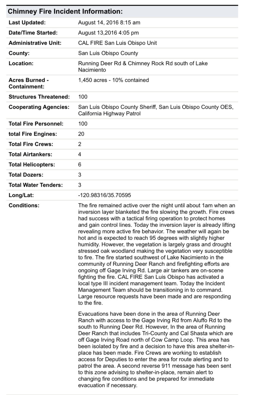
7 am – 4300 acres and 10% containment. Here is John Chesnut’s MODIS map of the Chimney Fire:

image

8/14/16

5:45 pm by Bill Mortiz

image

Today around 3 pm from Cambria by Joan Schlicher. Rocky Butte is on the right. Looks like a nuclear explosion.

image

3:25 – right now, photo by Michael Handy:

image

3:00 pm – SLO County Offices of Emergency Services says the fire has quickly exploded and those in the Tri-County and Cal Shasta area are to evacuate immediately. Those who can not get out of the area are to go to water’s edge where the SLO County Sheriff’s will be launching boats for evacuations.

10:30 am –

image

8:00 am – acreage updated to 1450 acres, 10% containment.

6:30 am – Chimney Fire is now 1000 acres and 10% contained. Here is the most recent MODIS from John Chesnut:

image

***********************************************************************

9:pm – latest update is 850 acres, back burns initiated and going well, VLAT photo by Rick Modlin:

image

Here’s an aerial:

image

5:10 pm – AA says multiple spots up to a mile ahead of the main fire are starting to take off, fire now 350 + acres, now 450 acres. BTW, it is 107 by the Paso Airport, so it will be about the same here.

5:00 pm – As if my life wasn’t busy enough –  this is a lot of fun … A fire just broke out ESE of me on the West side of Lake Naciemento. It is 100-200 acres and moving fast. It is on Chimney Rock RD. Near Running Deer Ranch, which is being evacuated. 5 tankers assigned at this point. This could get interesting – one to the north west of me and one to the south east. Hmmm…Here is what it looks like.

image

Soberanes Fire, Day 23, 8/13/16 -Local Reports

8:30 pm – today’s burn out operation om the west side of the fire as a slide show from Kyle Evans:

This slideshow requires JavaScript.

7:30 pm – Here is “find the firefighters” by Jeff Mallory

image

That is some steep country.

5:15 pm – from Steve Harper, edited for brevity and clarity:

To the left you can see mt Manuel and where the fire has stopped burning. You can see the Mt Manuel trail on the left and the Pine Ridge trail on the right. The very steep hand line is on the south side of the river and is running down the the back loop of the State Park campgrounds.

image

Anyway here is the photo. You can see the flank of Mt Manuel and the Mt Manuel trail and the road that goes up to the SP water tank, and the water tank itself. Further north are the ridges, some with visible flames. Steve Harper thinks the Gorge will be a problem, as he evidenced by asking about it at the last meeting.

image


00 pm – well this is a lot of fun … A fire just broke out WSW of me on the West side of Lake Naciemento. It is 100-200 acres and moving fast. This could get interesting – one to the north west of me and one to the south east. Hmmm…Moving to new post, will keep this one focused on Soberanes.

From Ken Wright at 4:18 pm – “Firing from Juan Higuera along the slope South the Gorge and beyond.” 1/2 hour later, Ken reports the back fire seems to be going perfectly. Here’s the view of it from Clear Ridge by Jen Smith:

image

3:45 pm – near Hopkins Ridge, by Kyle Evans

image

1:45 pm – Juan Higuera from Clear Ridge by Jeff Mallory:

image

12:30 pm – getting questions about the warned-about road closure, but I have heard nothing. One local in a burn out area was told (unknown level of authority) that if things didn’t go well with the burn out operations currently being conducted, a closure could be ordered. So far, all reports are that it is going well.

11:30 am – this is where the firing operation is going on – between Div breaks of N and O. It’s been going on for a while, per Soaring’s comment. My understanding (not a “for sure” thing by any means) is that the plan is to continue burn out operations, as weather permits down that dozer line through “N” to Div “ZZ” and further down, ahead of the main fire. This plan, of course, can change as the weather changes or the fire does.

image

9 am – today’s acreage is listed as 71,860 with containment at 60%. Want to know how the backburn on Coast Road is doing? Read Soaring’s eloquent and moving account in the comments section on this post. Made my day. Also reported that the backburn on the handline at Juan Higuera is going well, as well.

7 am – just a reminder, then I will be back later.

image

Soberanes Fire, Day 23, 8/13/16 – Maps, etc.

To give you an idea of where the Soberanes Fire is burning, we’ve included maps that are updated daily. These maps are provided by Cal Fire/US Forest Service.

The latest Heat Perimeter was detected yesterday at 9:00 pm.  You can see the latest Heat Perimeter on the Infrared Topo map. Note: The Heat Perimeter is not current on any other Official Map.

We’ve also included the Weather Forecast, Fire Behavior Forecast and various links that you may find useful. Note: Additional links are located at the end of the post. Some links may open large PDF documents.

Please see Local Reports for the current fire discussion.

Infrared Topo: IR_Topo0001.jpgInfrared Ortho: IR_Ortho0002.jpgIR LogImage2Weather Forecast0001.jpgFire Behavior Forecast0002.jpgOperations Map North: Ops North0003.jpgOperations Map South: Ops South0004.jpg

LegendLegend

Briefing Map: BAM0005.jpgProgression Map: Progression Map00001.jpg

Three views from the overnight flight and morning Satellite hits (provided by John Chesnut)

Saturday AM:Saturday AM.jpgApple Pie Burnout:Apple Pie burn out Saturday AMCachagua Saturday AM:Cachagua Saturday AM

Links:

Xasauan Today Satellite heat detection discussion

Google Maps Adam Clark’s Google Map with most recent Dozer lines, IR flight overlay, and the Planned Fire Line. Note: You may need to be signed in to a Google account to view this link.

Mapping Support Same as above, but on USGS Topo Maps

MesoWest Weather stations that are located near the fire. Scroll down to S07 Central Coast IRAWS. See the Blue WX rectangles on the Ops maps for locations. There are currently 7 portable weather stations deployed.

Flight Radar 24 Live Air Traffic for the area.  Note: aircraft flying at low altitudes may not be detected.

Additional Cal Fire/ US Forest Service Links:

INCIDENT PLAN Complete Incident Plan as of 8/13/16. Note: PDF may take awhile to download

IAP MAP CARMEL Dozer Carmel as of 8/13/16

IAP MAP SECO Dozer Seco as of 8/13/16

IAP MAP SUR Dozer Sur as of 8/13/16

Public Information Map PIO as of 8/13/16

Air Operations Map Air Ops as of 8/13/16

Firefighting Aircraft PDF guide with Cal Fire Firefighting Aircraft

SITUATION Situation Map (not current) as of 8/2/16 shows previous fire outlines

ELEVATIONS Elevations Map (not current) as of 8/2/16 shows hills and valleys in various colors

Soberanes Fire, Day 22, 8/12/16 – Local Reports

8:00 pm – fire is still 70,615 acres, but now 60% contained.

From my friend near Juan Higuera:

“This is from the hand line they built today on the N/Side of S/Fork of Juan Higuera. They started from a black knoll working their way down to a line to take across S/Fork tomorrow I suspect. Put in 6000 ft of hose to pump water to backup their operation. Have another 2500ft set up across from where they suspect the fire will go.

A good day for Fire Guys who were Billy’s goats today on a near vertical hillside. One I have not hike in 20 plus years!

My smile may return yet!”

Look closely. You can see a ff on the hand line below the fires. Way to go guys and gals!!

image

Perimeter of fire this afternoon, provided by John Chesnut:

imageimage

Noon, a slide show of the burn out operation yesterday by Scott Moffatt, who so generously let me grab whatever I wanted to share. (When he says: “left off Friday” I am sure he meant Thursday.

This slideshow requires JavaScript.

From Soaring:

“Huge amount of crews drove up in the last hour to restart the burn out on North Coast Ridge Rd, when conditions are right. Expect more smoke. This time it is a Sacramento strike team at our property. The Lassen strike team is following the burn operation south down the road. Across from us, to the east, the burn is still smoldering, has worked its way in the under story of the trees in the wilderness, every now and then we see a flare of a tree going up, but lots are still standing in the burn. Had a multitude of red fires out the window in the dark of the night, now it’s not so smoky. May all the conditions be favorable.” “Sorry, to clarify, those red fires I wrote about were small logs in the burn, putting up light and color, but there wasn’t much wind, the smoke went straight up. So far so good.”

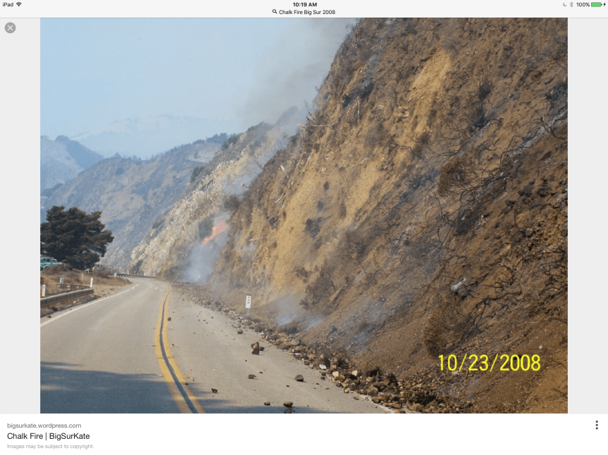
10:30 am – Since this fire first hit the national forest, the plan has been to hold it north of Nacimiento RD. Even today, on the situation report, that is the plan. In 2008, after the Basin Fire was finished, a new fire appeared on the South side of Nacimiento RD. In looking for info about that fire, I was referred back to my own blog … Hmmm…and was shown this photo:

image

9:00 am – Here is a slide show of some photos taken yesterday at Terrace Creek by Cordelia Cluett who lost the home she grew up in up Marble Peak in the 2008 Basin Fire. It provides a different perspective of the back burns yesterday. Thanks, Cordelia

This slideshow requires JavaScript.

From the Post Ranch looking East toward Ventana Inn of the back burn operation yesterday. Photo by Jeffrey Carmichael

image

7:00 am – Big Sur Valley is a bit on edge today, as communities usually are in front of a firing operation. The smoke is drifting down this direction more than it did yesterday, but still not as bad as it looked in town. Busy waiting for report ins from others, and checking on things, but hopefully, those in Big Sur Valley will start sharing their views, thoughts, and experiences after morning coffee.  Until then, sent last night by Michael Minasian of Big Sur Center, taken at 5:50 pm at 27,000′

image

Soberanes Fire, Day 22, 8/12/16 – Maps, etc.

To give you an idea of where the Soberanes Fire is burning, we’ve included maps that are updated daily. These maps are provided by Cal Fire/US Forest Service.

The latest Heat Perimeter was detected today at 12:30 am.  You can see the latest Heat Perimeter on the Infrared Topo map. Note: The Heat Perimeter is not current on any other Official Map.

We’ve also included the Weather Forecast, Fire Behavior Forecast and various links that you may find useful. Note: Additional links are located at the end of the post. Some links may open large PDF documents.

Please see Local Reports for the current fire discussion.

Infrared Topo: IR_Topo20160812_c0730_Soberanes_Aircraft3_11x17.jpg

IR Loglog2

Weather Forecast0001

Fire Behavior Forecast0002.jpgOperations Map North: Ops North0001.jpgOperations Map South: Ops South0002.jpg

LegendLegend

Briefing Map North: BAM_North0003.jpgBriefing Map South: BAM_South0004.jpgProgression Map: Progression Map0005.jpg

Links:

Xasauan Today Satellite heat detection discussion

Google Maps Adam Clark’s Google Map with most recent Dozer lines, IR flight overlay, and the Planned Fire Line. Note: You may need to be signed in to a Google account to view this link.

Mapping Support Same as above, but on USGS Topo Maps

MesoWest Weather stations that are located near the fire. Scroll down to S07 Central Coast IRAWS. See the Blue WX rectangles on the Ops maps for locations. There are currently 7 portable weather stations deployed.

Flight Radar 24 Live Air Traffic for the area.  Note: aircraft flying at low altitudes may not be detected.

Additional Cal Fire/ US Forest Service Links:

INCIDENT PLAN Complete Incident Plan as of 8/12/16. Note: PDF may take awhile to download

IAP MAP CARMEL Dozer Carmel as of 8/12/16

IAP MAP SECO Dozer Seco as of 8/12/16

IAP MAP SUR Dozer Sur as of 8/12/16

Air Operations Map Air Ops as of 8/12/16

Firefighting Aircraft PDF guide with Cal Fire Firefighting Aircraft

SITUATION Situation Map (not current) as of 8/2/16 shows previous fire outlines

ELEVATIONS Elevations Map (not current) as of 8/2/16 shows hills and valleys in various colors

Soberanes Fire, Day 21, 8/11/16 – Local Reports

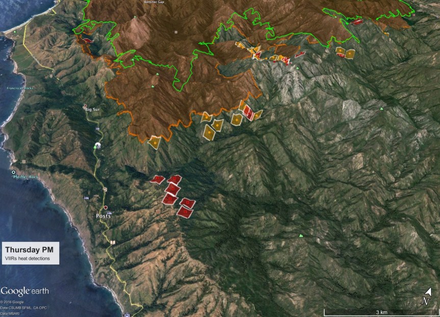
And from John Chesnut a similar one showing the back burn from behind Ventana to behind Deetjen’s. If you zoom in, you can see what looks like a dozer line on the ridge top, all the way down off the map. This may be the one left over from the Basin that is or will be used again.
image

From Keith Vandervere:

Firing operations begin on Coast Ridge. Thursday evening maps & notes https://xasauantoday.com/2016/08/05/soberanes-fire-week-three/

image

5:30 pm – the view north from my place. I am hoping that this is a backburn mentioned on FB as being back behind Deetjen’s. There appear to be two smoke columns. For orientation, the point sticking out WAY in the back (on the left) is Pt. Sur and  the Lighthouse, which I can see at night

image

From Kyle Evans looking south from Pfeiffer Ridge to Mount Manuel, on the left, with the fire camps below on Monday night – such devastation can also be so beautiful.

image

1:00 pm – From the beauty of the fire (see below) to the ugliness of some of our tourists:

image

Kathleen (Lee) and Byran (Flores) I got a call this morning. I went down to Old Coast Road next to Bixby Bridge and this is what I saw right behind storm drain. It is a hose used to pump an RV septic tank. Can you please notify CalTrans or whoever? I hope someone can get it out of there. Let me know if they can’t and I will do it myself. Also I would like the sheriff and CHP advised about this new approach to sanitation. Ken Ekelund

Here’s one of my favorite photos by Rachel Moody from Applie Pie Ridge, taken Monday Night. In my opinion, it is a classic.

image

10:30 am – Hopkins Ridge activity by Sharen Carey:

image

From BSHC:

NOTICE: BIG SUR HEALTH CENTER PSYCHOLOGICAL DEBRIEFING, Saturday, August 13, 11:00 am.
Dr. Ann Flood will lead a psychological debriefing in order to help prevent post-traumatic stress syndrome related to the Sobranes Fire. The debriefing will begin at 11:00 AM at Big Sur Health Center. Those wishing to have a private meeting with Dr. Flood will be able to meet with her after the debriefing. There is no charge for these services.
During the Basin Complex Fire we had similar counseling services which proved extremely beneficial for many residents. We hope you will take advantage of these complimentary services.
Spanish speaking services will also be available, if needed, provided by Eduardo Eisner.

Also on Friday, the 12th, the Soberanes Fire Fundraiser at the Golden State Theater. I will look for the flyer and post here:

image

And then on Sunday, there is another fundraiser here:

image

************************************************************************

From the Los Padres National Forest of the USFS:

Recreation Facilities that are Open on the Monterey Ranger District

GOLETA, Calif., August 11, 2016…Los Padres National Forest officials today clarified the campgrounds and day use facilities that are open for recreational use on the Monterey Ranger District.
Although much of the Monterey Ranger District is closed because of the Soberanes wildfire, the following sites are open for public use:

· Arroyo Seco Recreation Area
· Kirk Creek Campground
· Mill Creek Day Use Area
· Nacimiento Campground
· Ponderosa Campground
· Sand Dollar Day Use Area
· Plaskett Creek Campgrounds
· Willow Creek Day Use Area

The campgrounds at Arroyo Seco, Kirk Creek, Nacimiento, Ponderosa and Plaskett Creek require a reservation or are sometimes available on a first come, first serve basis. To ensure a camping space, please contact the concessionaire:

Rocky Mountain Recreation – http://rockymountainrec.com or (831) 674-5726 (Arroyo Seco)
Parks Management Company – http://recreation.gov or (805) 434-1996 or (877) 444-6777 (Kirk Creek, Plaskett Creek, Ponderosa, and Nacimiento)
Members of the public are reminded that they should call ahead to the Monterey District Office at (831) 385-5434 for the latest conditions and always consult the National Weather Service for current weather forecasts.

###

Here is this morning’s facts sheet:

imageimage

7:15 am – We have no IR map for the second day in a row, so the perimeter on our maps is out of date. Not much we can do about that, unfortunately. Up here, I can see a thick, heavy marine layer covering all the coast visible to me. It is almost chilly up here, so far today. This is a really good thing for our coastal areas of the fire. Hoping the marine influence will help the last stages of the battle to save Big Sur Valley today, which has thus far been successful. Hoping all can rest a little easier when this day is done.