Just a few minutes ago, the CHP reported this:
11:05AM 14 FM 1/COAST RD
11:03AM COVERING NB LANES IN BLIND CORNER
RESPONDING OFFICERS STATUS
11:04AM CHP Unit Assigned
I have no idea what “FM” means,

Just a few minutes ago, the CHP reported this:
11:05AM 14 FM 1/COAST RD
11:03AM COVERING NB LANES IN BLIND CORNER
RESPONDING OFFICERS STATUS
11:04AM CHP Unit Assigned
I have no idea what “FM” means,
Here are some wonderful photos of the snow on the mountains of Big Sur from Brandie Kirby of Cal-Trans, Big Sur Station. Thank you so much!!


For late NEXT week: “IF THE GFS WERE TO VERIFY WE COULD SEE SNOW DOWN TO SEA LEVEL.”
And a minute ago:
12:22PM HVY SNOW IN AREA
This is Empire Grade and Felton Empire. Lanes closed due to snow, also Empire & Pine Flat.
11:50 Empire Grade in Santa Cruz calling for snow plows:
11:48AM PER NET COM NO SNOW PLOWS, BUT GRADERS ARE ENRT
11:48AM 1039 NET COM
11:46AM REQ SNOW PLOWS
11:46AM 3″ + OF SNOW ON EMP GRADE
11:33AM PER RP TO NET COM **WILL POSS NEED TO BE PLOWED
11:32AM CORR: VEHS SPINNING OUT
10:30 am – you all are going to have fun today!

8:30 am – another mud/rock slide at MM 3.
8 am – South Bound Lane has been opened.
6 am, Saturday, February 19th:
From the CHP website: 3:16AM PER 27-S5 N38 DID A CHECK DOWN TO RAGGED POINT, MULTIPLE ROCK SLIDES BLOCKING LANES, MOST URGENT SLIDE @ MM 1
Given that NOAA is predicting yet ANOTHER inch and 1/2 of rain today, with snow levels down to 2500 ft, this road is not going to clear itself, and may be hard for Cal-Trans to keep up with, but they were on the job at 6 am this morning!
Here is the entire evening:
ADDITIONAL DETAILS
3:16AM PER 27-S5 N38 DID A CHECK DOWN TO RAGGED POINT, MULTIPLE ROCK SLIDES BLOCKING LANES, MOST URGENT SLIDE @ MM 1
2:44AM 1039 27-S5
2:42AM ADV WILL BE 1097 W/ 22G IN APX 5 MINS
2:40AM PALCED ONG CONES AROUND IT
2:40AM BOBERG CALLED F/ MM 3 @ A CALL BOX ADVZ>D THAT @ MM 9 PORTION OF THE NB LANE IS 1125 BY A LG BOULDER APX SIZE OF 5 X 5 ON A STAIGHT AWAY (note: this is Mud Creek)
2:14AM AT NACMIENTO RD MM 18
12:14AM SIG ALERT SENT
12:07AM 1039 SNS COMM
12:02AM 1039 22G LINE 56
12:00AM PER S5 – INFO VIA 27-S1 / REQ SIG ALERT FOR MONTEREY COUNTY / ADV OF PART CLOSURE / SMALL VEHS ABLE TO NEGOTIATE
11:46PM 1039 9-1X
11:42PM 1039 SLO REF LN S 44
11:35PM BOULDER PART 1125 SB LANE ALSO
11:21PM 97 – BOULDERS ACROSS NB LNS / VEH CAN PASS / TOW TK S UNABLE TO GET THRU
11:09PM LATE ENTRY 1039 SLO DISP REF LN S 24,26,27
11:03PM 1039 TO MTY COMM W/ INFO
11:00PM 22G AT WILLOW CREEK ETA 15-20 MINS
11:00PM 1039 DOT JOHN WOOD
9:55PM 1039 22G LINES 21-22
7:33PM 1039 DOT DIST 5 / ADV NEEDS TO CHK W/SUPERVISOR
7:22PM 1039 DOT DSP WILL ADV THEM UP THERE UNK IF THEY WILL GO OUT ON IT THO
The entire state, in effect, is under storm watch for today and tomorrow. Flash flood warnings are going out for many areas here in SoCal.
My SLO forecaster had this to say: ” A cold front stalled over Big Sur last night and produced heavy amounts of rainfall north of Cambria.
Three Peaks in Bug Sur recorded 5.94 inches of rain over the last 24 hours. Rocky Butte near San Simon reported 3.78 inches. Cambria has recorded 1.93 inches. …
Periods of moderate to heavy rain and gusty winds will continue through tonight, turning to scattered rain showers (at times heavy) on Saturday as a cold upper-level trough moves over the Central Coast.
Rainfall totals from this system should range between 1 and 1.5 inches in the North County (Paso Robles), 1.5 and 2.5 inches in the coastal valleys (San Luis Obispo) and along the beaches and 2.5 and 5.0 inches along the coastal mountains due to oragraphic enhancement.
Heavy snow above 3,000 feet in the Sierra will occur throughout the day today from north of Blue Canyon south into the souther Yosemite area. Also, heavy rain and snow in the 3,000 and 4,000 foot range will cross into the LA area late this afternoon and tonight with possible heavy snow across the Southern California Mountains.”
Just talked to my son, who is holding down the mountain for me, and it started snowing about 5 pm tonight.
A surf advisory issued this afternoon, and my dear friend Debbie sent me some photos, which I will post below.
I am still in Redondo Beach, and my mother is still hanging in there.


Major storms! Big Sur Valley reported 2 inches this morning. I am in SoCal with my dying mother, but the news reports are pretty amazing about the snow in the Rockies, the Sierras, and the rain every where – my daughter made it across the Rockies last night, just in front of the snow storm, and will hopefully be here this afternoon in time to say good-bye to her grandmother.
Next break in the weather is Sunday, looks like. Be safe, all.
Ah, time for a change. We had exceptional weather most of this year, so far, but that is about to change.
From NOAA: “A COOLING TREND WILL BEGIN TOMORROW IN EARNEST ACROSS THE DISTRICT AS THE WEATHER PATTERN TAKES A SHIFT TOWARDS A MORE UNSTABLE AND COOL ONE. BY SUNDAY AN APPROACHING UPPER LEVEL TROUGH WILL ENHANCE THE ONSHORE FLOW AS WELL AS INCREASE CLOUD COVER OVER THE STATE. RAIN IS FORECAST TO BEGIN ACROSS THE DISTRICT BY MIDDAY MONDAY WITH A STRONGER AND COLDER SYSTEM MOVING THROUGH ON TUESDAY. A COLD UPPER TROUGH ANCHORED ALONG THE WEST COAST WILL KEEP SHOWER CHANCES IN THE FORECAST THROUGH THE REST OF THE WEEK AS SYSTEMS ROTATE AROUND THE UPPER TROUGH. BY WEEK`S END…A COLD UPPER LOW IS PROGGED TO SLIDE SOUTHWARD OVER NORTHERN CALIFORNIA WITH LOWERING SNOW LEVELS.”
And from my SLO forecaster: “The cold front will cross the Central Coast north to south Monday night into Tuesday morning with scattered rain showers. Southerly winds will increase through the day Monday and will become gusty Monday night into Tuesday as the front passes.
Rain showers and gusty southwesterly winds will continue through Wednesday as an upper-level trough passes over our area. At this time, rainfall totals should range between 0.50 and 1.25 inches. Snow is expected across the Sierra, with snow levels initially at 6,500 feet, then dropping to 3,000 feet or possibly lower by Wednesday. Maximum temperatures late in the week next week will only range from the low to mid-50s, with minimums in the 30’s to low 40’s.
A break in the wet weather should develop on Thursday. However, another but stronger storm system is forecast to reach the Central Coast next Friday with gale force southerly winds and periods of heavy rain. Wet and cool weather could continue through the end of February, and possibly into early March.”
There is a LOT of smoke on the horizon out to sea. I’m guessing a controlled burn, probably at Ft. Ord, but will do some investigation and let you know.
And hour and a half searching, but can find nothing on this smoke, so I am going with a controlled burn. I remember the USFS notifying us that there was going to be a number of controlled burns on the Brazil Ranch through April, and of course, the old Ft. Ord is always a good bet.
BTW, the “shitty hang gliders” are back – you know, the “God is Awesome” Dodge Durango. I haven’t seen them, just been told about them. Let’s see if they clean up their prior mess – which despite rain and wind is still there!
Both my SLO forecasters, and the Monterey NOAA group are predicting rain mid-month. NOAA says: “MEDIUM RANGE MODELS ARE STILL INDICATING A PATTERN CHANGE BY THE END OF THE OPERATIONAL RUNS. AT THIS TIME THE RAIN CHANCES ARE STILL OUTSIDE OF THE FORECAST PERIOD…BUT THEY ARE EDGING CLOSER AND CONFIDENCE CONTINUES TO INCREASE THAT RAIN WILL BE BACK IN THE FORECAST BY THE MIDDLE OF THE MONTH OR SO.”
In the mean time, temps are progged to reach the 80s by Monday. Enjoy a beautiful weekend! Airship photos later today or tomorrow.
UPDATE – Thanks to Douglas Walling for his question about photos from up above. Last March I did an entire post on photos from up there. You can find it here: Mud Creek, March 2010
First, let me begin with the rain total for this last storm. I got a total of 1.25″ which brings the season total to 23.75 inches. Big Sur Valley got the same amount for the storm.
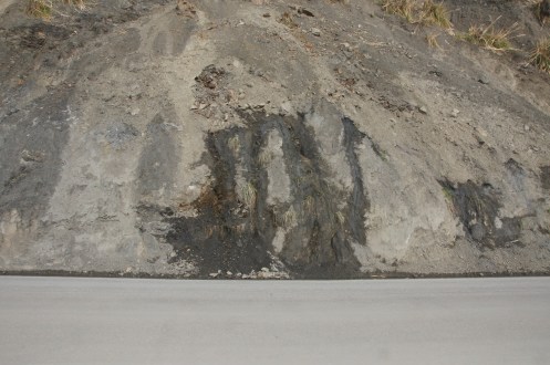
These photos tell the story of what is happening at Mud Creek. It is amazing to watch this much water just “leak” out of the side of the mountain. Remember, these photos were taken Saturday, BEFORE the storm, when we had been dry and sunny for almost the entire month of January. This is what happens to our road down here, and this is just one spot we are watching.