An hour later and that plume from the south eastern edge is almost gone, and we’ve got this one from the south western edge. A burn out operation at the Golden Stairs south of Pico Blanco, maybe??

5:15 pm – current photo from my place:

4:30 – here is a visual of the area of the mandatory evac for Tassajara and parts of Cachagua (warning to the rest of Cachagua) Thanks to Lucas Ryan:

3:30 pm – A backfiring operation in the area of the Upper Preserve was successful to create that coveted “black line” of safety.
5 ATs out of Paso are on a flight path directly over my house. Yesterday there were 8 and several of them made their last run at dusk. Go pilots!! But put your safety first, please.
3:30 pm – from the 1215 hours MODIS flight sent by Jim Kasson:


3:00 pm – Evacuation Center reopened at CMS; Those on Evacuation Warnings in Cachagua and Tassajara, pay attention for the issuance of a Mandatory, if the need arises.
1:30 pm – EVACUATION CENTER AT CMS RE-OPENS
11:00 am – South Side of Pico Blanco facing Post Summit last night. Photo by Matt Peterson or Derric Oliver

10:00 am – Also from Cachuagua as a result of a back burn being undertaken:
From Cachagua Fire:
Cachagua Fire Chief Curry, along with Battalion Chief del Valle, are working with the Soberanes Fire Incident Management Team and the Monterey County Sheriff’s Office to hereby notify all residents of the Cachagua Fire Protection District that an evacuation warning is being issued.
Residents should know that the fire is approaching the boundary of the district and firing operations will begin today or tomorrow.
Smoke and flames will likely be visible within the Cachagua Fire Protection District as part of this operation. Smoke can be detrimental to the health of the young, old, and those with breathing or heart issues.
You may have received additional information via reverse 911 or from local media sources. We want to emphasize that this is an evacuation warning.
This is NOT a mandatory evacuation order.
For more information, you can contact Chief Curry
10:00 am – From San Clemente Rancho about 2 hours ago:
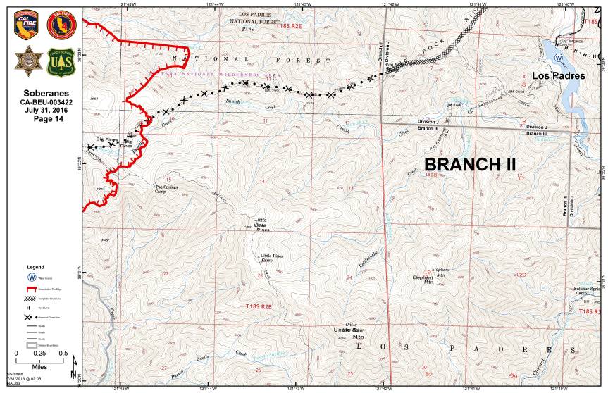
“To the south, the fire made amazing progress to the east yesterday burning through both the Big Pines and LIttle Pines areas of the Ventana…several miles at least! It is now backing down Blue Rock Ridge towards us (and the Cachugua).
To the West the Fire is making its way towards us via Ponciano Ridge and the South fork of the Black Rock Creek. It is now back out of the forest on our neighbors (the Lange’s & BLM) property.
Cal Fire has laid miles of hose line on the primary firebreak that Hank & I made but we still don’t have the air support everyone would like…the winds are predicted to shift, turning the smoke, not the fire) but that might come too late to help. Going to be a long next few days.”
Also hearing Evac warnings are to be given out to Cachuagua today.
****************
10:00 am – From Richard Cordova, Cal Fire PIO this morning.
Mount Manuel backfire planned for Monday, August 1, 2016
Cal Fire is planning a backfire on the eastern slope of Mount Manuel for Monday, August 1, if conditions are good. They are completing the dozer lines and advance work on this today. The plan is to back burn this section and join it with the larger fire. The timing is dependent on the weather. It may start in the morning but it could also be delayed until any time they determine the ideal conditions. Plan accordingly
****************
7:00 am – West Side of Pico Blanco, photo by Jen Smith

Photos by the Amazing Kodiak Greenwood of Pico Blanco and plume in background. Pico Blanco in this first photo is in the lower right. The burned ridge to the right and behind Pico Blanco is Skinner Ridge. The smoke-free mountain behind Skinner Ridge is Mt. Carmel. The big plume is rising from the Danish Creek watershed and Blue Rock Ridge (overlooking Cachagua) Per our resident expert, Keith Vandervere.


Per Keith, the one above is looking from Pico Blanco down Dani Ridge (with retardant stripe) toward the confluence of the forks of the Little Sur and the ocean. The smaller plume of smoke is coming from the burn out operation at the top of Serra Grade on the Old Coast Rd.

The second is of Moon’s property. Looks to me like most of the structures are still in the green and probably survived. Moon’s road is visible at the bottom. The summit of Serra Grade is on the right. From this photo I’m not sure if this burning is really part of the deliberate burn out or not.
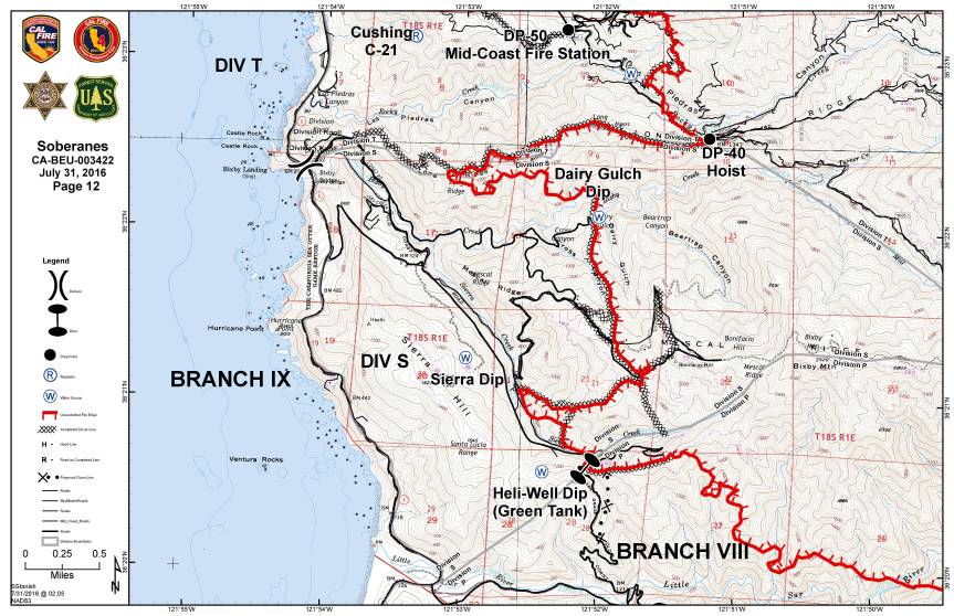
6:00 am – Dawn has finally arrived and I can visually see what is happening. No plumes, smoke is clear – fog socking in most of the coast, but doesn’t look to be very high. I have had an hour to check in, catch up on mail, and the like, and now ready for coffee. It really is a nice day to sit and watch the sunrise from this amazing perch and enjoy a brief respite of calm before the frenetic day of fire reporting begins. Remember to take a moment for yourself, take a nap, if you can. They can do wonders to rejuvenate you. Current IR Topo map puts fire at 38.007 acres. Lucas is busy putting together our maps for us.
Like this:
Like Loading...