
2:24 – now open, but power out indefinitely.
At Captain Cooper due to a downed tree, right where the damaged PG&E pole was. This will be a temporary closure, I believe.

2:24 – now open, but power out indefinitely.
At Captain Cooper due to a downed tree, right where the damaged PG&E pole was. This will be a temporary closure, I believe.


Photo Courtesy Honey Williams. Lower Long Ridge from July 24

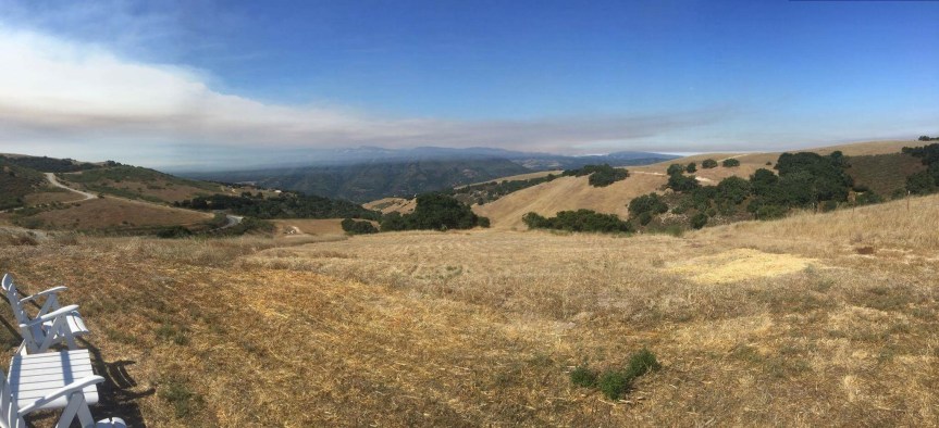
Photo By Mike Heisinger. Robinson Canyon Rd. July 24

Photo Mike Morales Robinson Canyon Rd. July 24

Photo by Mike Heisinger, Marsh Lake, The Preserve July 24

Photo SLO Stringer Palo Colorado

Photo Courtesy Michael Troutman
Evening fact sheet:

“Point Lobos State Natural Reserve is closed until further notice due to the Soberanes Fire. Current fire information can be found at the CalFire site here. Our appreciation and prayers go to all the men and women working around the clock to contain this difficult fire, and to everyone who have been displaced by it. This site will be updated once the Reserve has opened.” (http://www.ptlobos.org)
Map from tonight’s meeting. I think it is already out-of-date base on what I am seeing:

1:40 pm – Additional Road Closures:
12:11 –
Soberanes Fire Community Meeting TONIGHT
6pm at Carmel River School
15th and Monte Verde, Carmel
Meeting will be hosted by Cal Fire and USFS
District 5 will have representation
Last night’s IR flight on Topo:

From State Parks:
Kate,
All parks in the Big Sur Sector—Pfeiffer Big Sur State Park, Julia Pfeiffer Burns State Park, Andrew Molera State Park, and Pt. Sur Lighthouse Historic Park– are now officially closed to day use, hiking, camping, surfing, swimming, and special events (including softball).
State Parks appreciates the cooperation of the Big Sur community in respecting this closure order.
Michele
Michele Craig
Senior Park Aide, Administrative Lead
Big Sur Sector, California State Parks
Pfeiffer Big Sur State Park
ABSOLUTELY DYNAMITE OFFICIAL FIRE MAP:

Revised Facts Sheet to exclude Carmel Valley from the evac advisory, just like last night. Someone needs to destroy this guys first template! I’ve removed the original from my site to avoid confusion.

6 pm – that plume has moved considerably west in the last hour.
2:55 pm – this time, she blew, one of the largest plumes on this fire I have seen and it keeps growing.(there will be a photo later on a separate post)
12:30 big plume visible from down here. It is making a run someplace. One witness said this:
“Fire making a big run up behind El Sur Ranch, looks like it’s running up from north fork Little Sur, difficult to pinpoint exact location due to smoke haze. Many Dozers and fire personal between Little Sur bridge and Captain Cooper School.”
9:25 – need to slow down, I missed the second part of the donation flyer, so here it is:

9:08 Situational Map

Okay … Is that the golden stairs dozer line I see at the bottom of that map? I know the IC put in a request for overflow 50 dozers in his equipment request last night … Have no idea how many he will get. But I like this direction …
8:56 am –

7:52 – local resident reports Bixby finally getting some help.
And From Keith Vandervere:

7:29 – from a local resident, held in high esteem by most of us:
” When I returned from Pico Blanco area late last night very disturbed at the lack of personnel even patrolling the Old Coast Road for any spot fires. ”
7:08 am – updated IR flight sent by John Chesnut. Blue line is yesterday’s perimeter to show growth.

7:00 am – thermal image sent by Jim Barr who reports new detects NW & E of Bixby Mountain; W of Mt. Carmel; & W of Rancho San Carlos.

5:30 am – First off, some housekeeping matters. Today, I will begin three separate posts. This one, to add for local reports from the fire lines; the second one will be for official notices; and lastly a photo one.- go to the right and under “pages” you will see Soberanes Photos. Mike Morales will be handling that page for me, but he goes out at dawn for his own photos (with or without fires) and then checks in with various commands, then comes back to process and upload his photos, so he will be in and out all day. I will forward photos I receive to him, but I’ve given him complete and utter editorial discretion on what to post. It has been a while since he has worked with WordPress, so today will be a “work-in-progress” for him. I am SO thankful for his help!!
On official notices, if it is an evacuation order, I may send it out separately to make sure everyone on the two social media I monitor and post to – Facebook and Twitter – will see it as it goes up simultaneously. I’m going to play that one by ear today. If I do, that means when you visit my blog, you may want to scroll through various posts to get all of today’s news and photos.
I get a lot of questions which I did my best to answer or explain why there was no answer, both publicly and privately, sometimes answering the same question numerous times in the comment section, over the past three days. With private questions, I will make no promises I will answer, but will try with all reasonable questions, if I can. Today, I am instituting a policy from my legal career – Asked and Answered. I will answer only once publicly. You are responsible for checking prior comments to see whether your question has already been addressed. Many of you have become absolutely wonderful about answering each other’s questions when you can. I so honor and appreciate that as it saves me time and energy. If it is a question that calls for a crystal ball, I will not even try explaining why I cannot answer. If you have a visit planned here and are asking a question about that, I have one word for you – don’t. Honor us and the land, and don’t be a looky-loo who is so busy taking a selfie that you don’t realize you are in the way. It is smoky and not a good time to visit.
I am in this for the long haul and need to conserve and take care of myself, as so very many of you remind me. Last night, I did not get my solid 6 hours, but only got 4, so later this am I will try to get another hour in, whenever the lull hits, and it usually does. If necessary, I will do that several times today.
Okay, boys and girls, keep an eye on each other and the words for today are compassion and empathy for all living critters.
PLEASE READ THESE CAREFULLY!

Just issued at 9:30 pm – this revised fact sheet. The only differences I can tell are in the Evacuation Notices – and NO Carmel Valley is NOT included, and YES evacuation warning issued for Old Coast RD from Bixby to Andrew Molera.


From State Parks:
“We just had a meeting where the decision was made to close Pfeiffer Big Sur to day use as of sundown tonight. Current campers are being told they need to be out by noon tomorrow at which time the Pfeiffer Big Sur State Park will be totally closed.”
Mandatory Evacuation Orders Expanded

From Micah Curtis a few moments ago:
“Kodiak is at the Bixby ranch and says that the fire is creeping down into the north fork of the Little Sur drainage doesn’t see much fire fighting action. If the fire gets around Pico Blanco into the south fork of the Little Sur very good odds that it will crest the ridge above Big Sur Valley in a couple days. People in the valley should double down on their fire clearance. We have dozed out our fire breaks but midslope breaks are not that good.. Micah Curtis.” Okay, can I have a drink, now?
3:30 pm – the latest Fire Map at the Highlands Fire Station:

New MODIS from John Chesnut:

2:57 pm – Revised Evacuation Warning:

2:00 pm – I cannot stress enough how important it is to read the comments, ALL of them, for additional information from people on the ground and in the midst, who are telling what they actually see. I don’t have the time or energy to copy and paste them all.
Also received this from a reader:
“3 trucks and 3 dozers are stationed at White Rock Club just above our family cabin…dozers going to new fire roads to fight fire from that front. It is very close. Thank you to those who are fighting for us all.
1:50 pm –
1:30 pm – CV Airport, photos by Matt (No last name given)


Laureles Grade, photo by Jim Barr

12:50: From Sehr Evens: “Well it’s official. We received confirmation from our neighbor this morning, our house is gone. My fathers home that he built by hand, my childhood, my roots, my family stories, gone! Thank god our neighbor somehow survived. I was so worried for his life but he somehow lived through this although his house is gone. My dad is also safe, he evacuated Friday night thank god. Here’s what I know with most certainty about our little part of the road, The only two house that survived where Curtis Gilmans and Rebecca Roveto old place(the fire apparently jumped over them as there was no one defending them). Everything else on our little area is gone. Everyone that I know of from Rocky creek that staid is alive although the only other house I know im of that survived is Brian Patch’s. I’m assuming all other are gone unless somehow the fire hopped it.
Thank you to everyone who has sent your prayers and love. What really matters right now is that as far as I know our people are alive and well.”
Unconfirmed Reports of up to 25 houses lost in various areas, and others under attack.
12:45 pm – just got word there are a number of homes on one side of Green Ridge that have been lost. I don’t have names, and even if I did, I wouldn’t give them out. Check with neighbors still there. New flare up on Garrapatos is threatening another set of homes. No further, so again, check with those still there … But remember, some of your neighbors are fighting right now and don’t have time for questions. So PRAY. And if you want to help? Volunteer at the shelter, take cold water to firefighters in your neighborhood, and the like. If anyone needs help with large animal Evans, I have a contact I can pass along.
12:30 pm – Photos from Alan Buchwald on Weston Ridge RD. From last night and this morning:


Photos from Chelsea Rullo from CV


12:15 pm – I get frustrated some times with questions I get during emergencies, but I get a lot of people complimenting me on the work I do – BUT it is ONLY because I have been at this for 8 years now and have built up a phenomenal support group of informational gathering locals who can provide me with the real scoop and amazing photographs that allows me to do the work I do. Thank you all for this unique and blessed community of Big Surians, near and far.
Taken at Midnight last night by Peter Nichols:

11:30 am – fire trucks just spotted going up Old Coast Road, hopefully to Bixby Mtn spot or to preposition, 8-10 trucks, WT, etc. See comments section for report. Also 14 trucks headed East on CV Valley RD.at 10:30
And then this photo from Mike Morales taken from Robinson Canyon Road after dawn this am:

11:00 current photo from Laureles Grade by Sandy O’Keefe Bellamy, who just PM’d that the smoke is increasing again – might be getting ready for another run.
Another map from Scott Thomas showing relationship to Boy Scout Camp. Note spot ahead of main fire on Bixby Mtn near Botcher’s Gap

Here is a link to Keith Vandervere’s amazing video of the DC-10 drop on Mal Paso yesterday:
Photos by Michael Troutman from last night:

Great history of fire in the area on Mid Coast Fire Brigade website here:Mid Coast Fire Brigade
1o:00 am – just got notice that she is running again. Huge Plume visible from Fire Camp on El Toro Park. I cannot see squat.
9 am – From Keith Vandervere:

Cal Fire Fact sheet:

Sent to me by Jim Barr:

Sent by John Chestnut, a great IR map interpretation from just before midnight – even shows the spot on Bixby Mtn

7:40 am – report from the front lines that all cabins in Garrapata Canyon were saved last night. The fire wrapped around them. Good news always welcome.
7:15 – reported that John Moon is taking a backhoe to the fire on Bixby Mtn. (He promised to be careful) The authorities did not know where Bixby Mtn is.
6:45 – Got a report from a resident on Mescal Ridge time stamp at 6:34 am (thank god I was up and had started working) that the fire had topped Bixby Mtn. And was headed to the Little Sur River and he didn’t think the authorities knew about it, so he asked me to notify them. I called 911 and so did he.
6:30 AM – Woke to a completely smoky morning down here – can’t see much of anything. Can’t see Willow Creek top at all. A little better to the north, but not much. Wondering if in my single minded-focus on Soberanes, I might have missed another? That thought crossed my mind yesterday afternoon, too. Okay – give me a 1/2 hour to get up to speed, and I’ll be reporting my findings.
I received a lot of photos today, but nobody put more time in my day. Now that it is dark and news has quieted, I can post a few of the ones I think are either great photos, great perspective, or otherwise contribute new information for today’s events. I will simply identify the place and time, if provided, and the photographer. If I don’t include yours, if might be that it is just lost in my inbox, on Twitter, or FB. I get them through so many different methods, it is really hard to keep track. Doesn’t mean I don’t want them or think they are not worthy of posting, it only means I am one person – flawed, busy, and at times, disorganized.
With these images, I bid you good night. I’ll be up and gathering info early, but probably not ready to start posting until 7 when I have a feel for what happened overnight. Love, blessings and healing to all of us and our land.
From Stephen Adair, around 10 pm showing upper Mal Paso Canyon;

From Scott Moffet tonight, taken from Coast RD. Behind Ventana:

By Clayton Scicluna, taken from Post Ranch this afternoon:


From Bruce Dormody at dusk, showing the fire crossing White Rock Ridge into the Garzas.

From Lucas Ryan shot from White Rock Cabins

From Juanita Turner tonight from CV

Jane Goldcamp, CV around 8:45pm

These by Steve Parlato around noon from Pebble Beach Golf Course:


That’s it, I cannot do anymore tonight.
8:30 pm – This is my last photo of the night on this post. If more needs to be posted after dark, I will do so on a new post, a practice I started during the Chalk in order to limit my posts to two a day.
I have a soft spot for the convict crews, probably because I was a public defender at the trial or appellate level for 30 years and had clients who worked these crews. Also, I have known as friends a number of Cal Fire crew bosses who worked with these guys. They are hard working and really give it their all for a few bucks a day and the chance to work outside the prison walls. It is a plum assignment, and there are stiff requirements to get on a crew. But when I see that long orange line, I always tear up. Photo by John Galt.


I think he means “Weston Ridge RD.” Not Western Ridge RD. At least we now have official situational reports.
7:00 from Trina Hammack again, Mid-Valley. Yup, it has exploded.

7:00 pm – it’s blown up again. These two photos were taken just now, only a minute apart, both at 300 mm telephoto, from my watch tower up here: (Insert favorite expletive here)


6:22 just in from Cal Fire Statewide PIO: 6500 acres, 5% contained, and they used Mike Morales DC-10 retardant drop photo to tweet it. Congrats, Mike
6:15 pm – Oakland, Fremont, Hayward, & Alameda FD each sending engines and boots down to us! Yeah, East Bay. SF is already on the way.
This just sent at 6:09 pm:

4:00 pm – Top of Country Club Drive, CV, photo by Anthony Jabin:

DC-10 retardant drop by Mike Morales taken this afternoon:

3:15 pm – top of Cachuagua Grade, photo by Siobhan Warwick Griffin Wolfe

This photo taken not long ago by Trina Hammack, clearly shows this is a 3-headed beast:

2:30 – changed to an evacuation WARNING not a voluntary evacuation:
Fire and law enforcement have issued an evacuation warning for all areas of Carmel Highlands due to the potential spread of the Soberanes wildland fire to the north of its current location.
Residents are encouraged to be prepared to leave the area immediately in the event this is upgraded tp a voluntary evacuation order. Be prepared to take any medications, pets, family valuables, etc. Also, please close all windows including window coverings and leave all doors closed and unlocked if you leave.
From Monterey OES:
2:00 pm – Fire and law enforcement have issued a voluntary evacuation notice for the area of Carmel HIghlands from Corona Road at the north end to south of Mal Paso Creek at Aurora Del Mar due to the potential spread of the Soberanes wildland fire to the north of its current location.
Residents are encouraged to leave the area as soon as possible. Be sure to take any medications, pets, family valuables, etc. Also, please close all windows including window coverings and leave all doors closed and unlocked.
A temporary shelter facility has been established at Carmel Middle School, 4830 Carmel Valley Road.
Photos taken Saturday 7/23 at 1:30 pm – from Boots Road and Saddle Road by Jim Barr:
View to South

View to the West
seems to have been misplaced, for the moment. I am too tired to figure it out, so will try again tomorrow, or just skip this one. My photo library is now in utter, and complete disarray tonight, and I am not doing anything about it until I get a little perspective back. Manana, people.
View to the South West

1:40 – Photo by Jane Goldcamp

1:15 am – let me give a description from my iPad here at my work desk. There is another HUGE plume. She is running again. In addition to the plume, there is smoke from behind Cone Peak out to the ocean, and south along the horizon as far as I can see. This puppy is pumping today, and that is not a good thing.
12:45 am – I am hearing that the wind shift that is currently taking place means the fire is making a run northward. As stated below in the comments section, this was somewhat anticipated as evidenced by the propositioning of some engines and other equipment about 10 this morning on the southern/eastern end of the Highlands.
From Mike Morales: “Wind is fierce now from Hurricane Point to Malpaso Creek Bridge. Looks S/W at gusting easily to 40+. Saw ash flying south of Bixby Bridge also leaves and debris airborne. Haven’t seen that in awhile.
The move north is astonishing. 1/2 mile from Malpaso. Went into the neighborhood and the two residents I spoke with were clueless if not defiant but once I mentioned the wind change they perked up.
CalFire based in the Highlands are patrolling.
No fixed wing or rotary. I suspect the wind is begging them off.”
12:00PM SOBERANES FIRE UPDATE 7/23/2016
All information confirmed with Monterey County OES, Cal Fire and Monterey County Sheriffs Office:
-Burn area now estimated at 3000+ acres
-1000 structures threatened
-Boy Scout camp had over 350 people shelter in place overnight and all were safely evacuated this morning
-Evacuation orders in affect for Palo Colorado, door to door notices
-Palo Colorado Rd, Lower Garapatta Rd and Westin Ridge Rd currently closed, Hwy 1 remains open
-Red Cross and SPCA shelters located at Carmel Middle School and are currently accepting donations onsite
-Incident Command Type II Team setting up at Toro Park, Cal Fire Garden Rd office currently command site
-Incident Command has been given control of Cal Fire BEU Twitter feed and will be posting updates directly from the team
-Information on air attack and ground crews will be posted shortly, teams from all over California and nearby states are in route
From early today (from the Palo Colorado Neighborhood list.)
“UPDATE FROM PALO RESIDENT: Andrew Hall from Mid-Coast
Hey All,
So as I was packing and preparing early this morning around 6 to leave a fire broke out on our property on the south side of garrapata ridge (the fire jumped the ridge by ember). I called calfire right away and then an hour later to report. After about 3-4 hours after the fire start a spotter plane and helicopter arrived. The helicopter dumped water on the upper portion of the fire that was making a run for the ridge. The fire was still spreading down towards our house, as well as east and west along the ridge. The canyon was empty heading out except for a cal fire personal who said he was going to take a look at it to see if he could get crew in. The fire is easily defensible, I have a fire hydrant right at it’s base, a trail leading to the southern flank and an access road that was cleared down below. The fire is spreading but not at an extremely rapid pace, so I will cross my fingers it can be put out. Hope everyone got out safely and that our firefighters can put it out safely.”
Saturday, 7/23 at 11:30 am by Jane Goldcamp from a ridge in Carmel Valley.

Here’s the same thing from Salinas, about the same time:

And one from Marina

My retired fire fighting friend, and co-administrator when I need help, Mike Morales took this one this am, pre-dawn. Yes, that is a light on someone’s house in that shape. Love it!

10:08 am – Report from Garrapatos RD. The Calvary has arrived and they are bombing the sh*t of the fire that is approaching.
From earlier this am,
From the helipad furthest west on Whiterock Ridge.
It’s running south to the back side of the Ridgeline running down from Mt. Carmel. Seems really hard that it would run this way. That’s about five miles away. Absolutely no activity up here.
Please credit photo and info by Paul Ingram. He’s onsite.


9:50 am – plume died down, it is quieting down, thankfully. My friend’s panic is abating after puking. Here are a couple dawn photos taken by Mike Morales:


9:20 am – I have been notified by a local that the fire is only 1000 ft from taking out Garrapatos Road. And 9 homes that stand in its way. This local has, until now, remained calm and the voice of reason in the face of panic by so many others. That probably scares me more than what this person has to say. I am watching the drama unfold to the window to my right as I sit here at my iPad. I can watch from a safe distance, but my heart cries for my friends, my old neighborhood, and the land.
9:00 am – It is running again!! I can see a major increase in smoke over the past few minutes, plume building rapidly. Any photo I take will be outdated in minutes, but will try.
Oh, and here is a photo taken by John Selmo around 8:30 am from Mal Paso showing the northern edge of the fire.

Fire map from 7 am briefing. 1800 acres, 0% containmentk. BTW, for the uninitiated, that line of crosses to the north of Palo Colorado Canyon usually denotes a dozer line that has been or is being cut. I learned that from many times attending these meetings over the years. 😉 Keith Vandervere says that thermal imagining puts the fire much further east than this map shows.

Helicopter 106 all good and back in the fight this am. Photo by Matt Vogelpoht this am in CV.

Here is the view from the north, taken at 7:50 am – Ridge above CV, photo by Jane Goldcamp. But according to Keith’s fire activity map below, most of the activity last night was to the south.

From XT:

REMINDER: PALO COLORADO RD AND WESTON RIDGE RD BOTH CLOSED UNTIL FURTHER NOTICE!
photos by Kodiak Greenwood, sent by Lisa Kleissner:


See the house? Amazing.
Photo below from last night from Weston Ridge, Photo by Maren Muter, taken at 10 pm-(okay, must have messed this one up. Will go back and look for correct photo.)

7 am – Uh, oh … There is a plume forming. Darn. BTW, must be expecting lots of support for lots of days as they moved the location of the Fire Camp from Garrapata Park to Toro Park. I know the food vendor.
6:30 am – got 5 hours of sleep last night. Now, I’m playing catch up. No visible plume this am. Fog over the ocean moving in down here, appears to be on the coast further north. By or shortly after midnight, fire given as 2,000 acres with eminent threat to at least one structure on Palo Colorado (I’m guess really Garrapata Ridge, since that would be first) but don’t know whose. Boy Scout Camp sheltered in place with MCSO, Cal Fire, and Ham Operator on site.
Here is a rather dramatic photo from Garrapata Ridge by Jessica Neafsey:

I’ll have more after coffee, and as more information becomes available.