

7:15 pm – “These are the Zuni Firefighters from New Mexico..they are going around to each resident on East Carmel Valley Road several miles up from the Arroyo Seco Rd. intersection, to make sure there is enough defensible perimeters around structures to be protected in case the fire comes in..amazing how considerate they all are..Clybert is standing by the car…bless them for all their personal safety concerns and hard work..we all have evacuation warnings here..
Alva Ana Sargenti…East Carmel Valley Road…”


John Chesnut’s pm map:

Looks to have been more quiet than expected. Always welcome.
Great short video describing what happened last night and what is expected today here:
And for those of you who want to see the proper, ano very detailed group of weather forecasts for both sides of the fire go here: (too many for me to upload)
Weather matrix and discussions
This from Tassajara:
The fire is moving closer to Tassajara. There is large potential for a wind event beginning this afternoon into tomorrow morning, with gusts up to 30 to 40 mph from the NW. This is significant not only because of the high winds but also because of the direction, which topographically lines up with the Church Creek watershed to Tassajara. Many pairs of eyes are watching for this weather event.
Today (9/22), the ZMC Fire Brigade is preparing for the possibility of the Tassajara firing operation starting at around 12 PM. Depending on conditions however, it may start today, tomorrow, or the next day.
Also, remember the Monks have the Alpine Hotshot Crew with them to help this time.
Here is the trail map Big Sur Trail Map

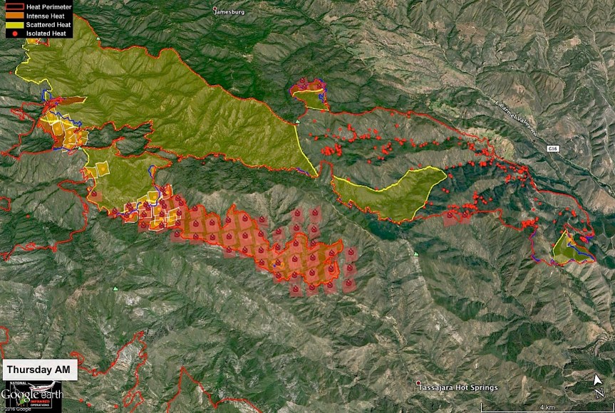
10:00 am – Here is John Chesnut’s map for this am, as well as the usual update by the USFS:
Daily Update: September 22, 2016 (this is the “Press Release”) – personally, the information found on inciweb is a bit more thorough, including weather predictions.
I would suggest visiting and bookmarking:
CONTACT:
Fire Information Line: (831) 204-0446 – Email: soberanesfire2016@gmail.com (Which has never answered me)
Current Size: 125,344 acres (88,150 acres CA-LPF; 37,194 acres CAL FIRE)
Containment: 71% Personnel: 2,302 Cause: Illegal campfire Injuries: 1 fatality, 7 injuries
Structures Destroyed:
57 homes, 11 outbuildings
Current Situation:
High winds with gusts as high as 35-40 mph are expected to continue through today. A dry cold front will create challenges in all areas of the Soberanes Fire, particularly along drainages that align with wind direction. Steep terrain and drought-stricken fuels increase the likelihood of difficult control efforts.
High winds overnight were counteracted by higher than expected relative humidity, limiting fire spread. Continued high winds are likely to increase intensity along the fire edges. The winds also will test the containment lines and could cause increased activity in seemingly dormant areas of the incident.
Firefighting efforts on Wednesday were focused on two spot fires burning outside primary containment lines. The spot fires were the result of wind-blown embers from within the containment lines. Neither spot fire expanded on Wednesday. Aggressive mop-up operations will continue today.
Line-building burnout operations, which were highly successful in recent days are largely on hold until weather conditions are more favorable. In the face of difficult conditions, efforts today will be to successfully hold established fire lines. In all cases and at all times, safety of firefighters and the public are paramount.
Evacuation orders and warnings remain in effect in the eastern areas of the fire. Information on evacuations is available at http://inciweb.nwcg.gov/incident/4888 (click on the Announcements tab).
Air monitoring is being conducted throughout the incident. Communities affected by drift smoke include Tassajara,Carmel Valley, Cachagua, and Arroyo Seco..
A community meeting is scheduled for 6 p.m. on Saturday, Sept. 24, at the fire station in Arroyo Seco, 46700 Arroyo Seco Road.
For more information, visit: http://inciweb.nwcg.gov/incident/4888/ or follow us on social media at http://www.facebook.com/LosPadresNationalForest or http://www.twitter.com/LosPadresNF.
Other contacts: SPCA, (831) 646-5534; American Red Cross, (831) 424-4824.
6:30 am – here’s one I haven’t seen before – an IR Operations Map:

5:00 am – And, one more time, ladies and gents … Another almost 2k acres added … For a total of 125, 230 acres …


And here are the morning’s fire behavior and weather prediction discussions:


