

State Wildfire Map, 7/12/17

4:15 pm – apparently, these fires were small veg fires along 101 from Atascadero up to Paso so far…..I’ll bet some ones dragging a chain….we’ve got units from Atascadero, templeton, an Paso running 101 putting them out. Currently, all but one is small and mostly in the center lane. One is at Exline, which is very north end, where the PR RV Parks is. I’ve stayed there many times. This one bears watching. This is a mess. Read the CHP report below. Glad I am not in Paso today…
4: pm – I took the day to run to King City, so just catching up, here. Looks like someone drug a chain, and sparked a bunch of fires. Let me catch up and I’ll update, but in the mean time, here is the chp dispatch:
4:14 PM 38 [144] 1039 CALTRANS
4:14 PM 37 [143] 1039 9-L,MADE NOTIF TO DIV CHIEV//REQ ADV ENTAC IF UNITS ARENT ABLE TO OPEN A LN
4:12 PM 36 [140] [Notification] [CHP]-PRPD REQ CLOSE NB 46W ONR AND CLOSE THE NB RAMADA TURN LN TO WB 46W//PRPD HAS CITY STREET CREWS ENRT TO ASSIST [Shared]
4:08 PM 35 [134] 1039 CALTRANS // ALRDY HAS 2 SUPV ENRT TO AREA
4:06 PM 34 [132] B9-008B NB N SPRING OFR IS CLOSED // PASO PD HAS NB ONR CLOSED
4:06 PM 33 [131] 1039 9-L,REQ ADV ENTACT IF CLSOURE IS LONGER THAN 90 MINS
4:05 PM 32 [129] B9-001B 101 AT SR46W // DIVERTING TRFC OFF AT SR46W // TRAFFIC IS GRIDLOCKED
4:03 PM 31 [128] [CHP] has closed their incident [170711SL00170]
4:01 PM 30 [125] 1039 9-L
4:00 PM 29 [124] [Notification] [CHP]-RP ADVS 15-20 VEHS BEING 23103 NB 101 AT MAIN FLIPPING AROUND , NEAR TCS DUE TO FIRE IN THE AREA AND FRWY CLOSURE [Shared]
3:57 PM 28 [121] [Appended, 15:57:30] [1] RP ADV AT A CARE FACILITY NR THE FIRE JNO N SPRING,CONC ABOUT NEEDED TO EVAC PATIENTS
3:56 PM 27 [118] B9-008 ADDTL FIRE NB ON NB SPRING OFR AREA WILL 1023 TO ASSIST
3:39 PM 26 [117] [Notification] [CHP]-CAL FIRE L/L REQ UNIT SHUT DOWN SPRING ST OFR [Shared]
3:36 PM 25 [116] B9-004B NB 101 CLOSED AT SPRING
3:30 PM 24 [104] [Appended, 15:31:54] [1] RP ADVSD BRUSH FIRE NEAT STOCKDALE AND EXLINE
3:22 PM 23 [69] B9-001B VINEYARD OFR IS RE OPENED
3:21 PM 22 [67] [Notification] [CHP]-PER ATAS IF WE HAVE ANY UNITS RESPONDING TO THE FIRE IN THE CITY THEY CAN 1022 [Shared]
3:21 PM 21 [100] [Appended, 15:26:46] [22] [Notification] [CHP]-CAL FIRE ADVSD NOW STATING ADDITIONAL FIRES PASSING MONTEREY
3:19 PM 20 [46] B9-004B HAS S SPRING OFR CLOSED
3:18 PM 19 [45] FIRE ALSO RPTD SR46W // N SPRING // S SPRING // SR46E // MONTEREY
3:17 PM 18 [49] [Appended, 15:19:24] [2] BRUSH FIRE
3:16 PM 17 [52] [Appended, 15:19:29] [1] ADDTL CALLER ADVD FIRE STARTING AT SR46E
3:15 PM 16 [61] [Appended, 15:19:35] [9] [Appended, 15:15:55] [2] TOT CAL FIRE
3:15 PM 15 [60] [Appended, 15:19:35] [8] [Appended, 15:15:55] [1] FIRE BTWN N SPRING AND WELLSONA
3:14 PM 14 [57] [Appended, 15:19:35] [3] ANOTHER FIRE ON MONTEREY
3:13 PM 13 [55] [Appended, 15:19:35] [1] BRUSH FIRE
3:13 PM 12 [96] [Appended, 15:26:46] [29] [Appended, 15:24:18] [7] [Notification] [CHP]-PER CAL FIRE – RESP TRK FOR STARTING FIRES MAR FBED SEMI TRK JUST TOOK EB 46E FRM 101 OK 28 CHXM37
3:13 PM 11 [95] [Appended, 15:26:46] [28] [Appended, 15:24:18] [6] ADDTL FIRE AT 46W – CAL FIRE COPS
3:11 PM 10 [84] [Appended, 15:26:46] [13] B9-001B NB VINEYARD OFR IS CLOSED
3:10 PM 9 [42] [Notification] [CHP]-PER CALFIRE,BELIVES FIRES POSS STARTED BY VEH DRAGGING A CHAIN,REQ UNIT BOL [Shared]
3:08 PM 8 [72] [Appended, 15:26:46] [3] B9-001B VISUAL OF A FIRE AT VINEYARD
3:07 PM 7 [70] [Appended, 15:26:46] [1] FIRE STARTING ON THE LAS TABLAS ONR
3:06 PM 6 [40] [Appended, 15:09:31] [2] FIRE DEPT IN THE AREA
3:05 PM 5 [24] [Appended, 15:05:26] [1] CITZ STOPPED TRYING TO PUT OO FIRE
3:02 PM 4 [7] [Appended, 15:02:49] [1] FIRE STARTING ALONG RS
3:02 PM 3 [3] TOT APD FOR FIRE
3:02 PM 2 [4] [Appended, 15:02:22] [1] BRUSH FIRE ON RHS
3:01 PM 1 [1] BRUSH FIRE
Unit Information
3:19 PM 12 Unit Assigned
3:19 PM 11 Unit Enroute
3:19 PM 10 Unit At Scene
3:56 PM 9 Unit Assigned
3:56 PM 8 Unit Enroute
3:56 PM 7 Unit At Scene
3:56 PM 6 Unit Assigned
3:56 PM 5 Unit Enroute
4:06 PM 4 Unit Assigned
4:06 PM 3 Unit Enroute
4:10 PM 2 Unit Assigned
4:10 PM 1 Unit Enroute
MONDAY, JULY 10-HIGHWAY 1 CLOSURE UPDATE: FROM JUST NORTH OF SALMON CREEK (MON 3.0) TO THE “MAF” (PM 46.35)- PAUL’S SLIDE CONTINUES WITH LOCAL/DELIVERY ACCESS AND MUD CREEK REMAINS CLOSED INDEFINITELY–NEXT UPDATE THURSDAY, JULY 13.
No changes since last update, Friday, but here are a couple photos of the progress on the Pfeiffer Canyon Bridge:


BTW, FRA is federal responsibility area and SRA is state area responsibility.
8:00 am –
Whittier – 10,823 acres and 10% containment (Lake Cachuma)
Alamo – 29,000 acres and 15% containment (E. of Santa Maria)
Stone -340 acres and 40% containment (Santa Margarita)
Parkfield -1816 acres and 80% containment (San Miguel) Unless there is a significant development, this will be the last report on this fire.
Garza – 5000 acres and 5% containment (Fresno/SLO/MoCo border)
5:00 pm – people and 2 of 3 horses okay. 1 horse MIA

4:30 pm – here is a google map of where the Stone Fire started:

4 pm – FYI – there is yet ANOTHER fire near the SLO/Monterey/Fresno line out on Jack Ranch near Chalone, but won’t be creating a new thread while Stone is threatening lives. Jack Ranch (the Garza Fire near the border of MoCo/SLO Co/Fresno) I will come back to – maybe.
3:30 pm – from SLO OES: Evacuation Order for #StoneFire. HWY 58 from Huer Heuro north to O’Donovan & Shooting Star. Including Blue Rd, Blue Ridge, Isabel Rose Ln
3:00 pm – IC is asking for anything that’s available. “Structures are occupied, burning, and threatened”. 2-300 acres 7 Tankers en-route, No divert – Life threat for occupied structures
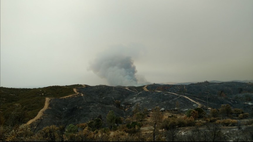
Photo by Nicklaus Johnson. Can see where the other fire burned just a week or two ago in Santa Margarita…
2:30 pm – A new fire out near Huer Huero Rd near Creston just started and is up to 100 acres with RROS. Some structures involved and other strictures threatened. “All tankers diverted from the Whittier Incident to the Stone for immediate life threat to civilians.”
Not good at all…
9 pm update:
Alamo: Update : 23,876 acres – 15% contained
Whittier: as of 11 this am – The fire is 7,800 acres
Parkfield: Update : 1,816 acres – 60% contained. Forward spread stopped.
Stone: Update, 340ac, forward progress stopped. Structures lost.
Garza: Update 2000 acres
7:00 am updates:
Parkfield: as of around midnight last night, this one is 1500 acres and 30% contained.
Alamo: as of 6 am this one is up to 23,867 with 10% containment and heading west and south toward the 101 and Santa Maria. Here is a fire map:

Whittier Fire: is 7800 acres and has crested Santa Ynez mountain and visible from Goleta now. This was 11 pm last night and from Goleta:

9:20 pm – 500 acres, per Cal Fire.
9:00 pm – PER CO RDS, HAVE CLOSURES IN PLACE AT: INDIAN VLY AT VINEYARD CYN / INDIAN VLY AT CROSS CYN / CROSS CYN AT PLEASANT (WHICH COVERS LOWES CYN – UNABLE TO CLOSE AT LOWES CYN BECAUSE VEHS UNABLE TO TURN AROUND AND SLOSO AWARE
Also evacuations but unknown where. Lastly, one firefighter suffered 2nd degree burns to his face and hands. He was airlifted out to a burn center.
7 pm – Location: Vineyard Canyon Rd x Cross Country Rd
Acres: 100
ROS: Dangerous rate of spread
ROC: 100 acres, requesting 1 additional Charlie strike team, 1 Lima ST, 2 Gulf STs. Fire burning on both sides of the road. In both MoCo and SLO
Ordered 2 more ATs for a total of 6.
Here are some photos I found online:


4 pm here is a shot of the Whittier Fire. (The Chalk Fire is a done deal)

3 pm – Busy day on the Central Coast. The newest one is up by the Chalk Mountain Golf Course in Atascadero Do not know size or have further info.
The one called Whittier has capped out and is 200 acres, right now. It is in some rough terrain. It is in the Los Padres NF in Santa Barbara County off 154 near Lake Cachuma.

Alamo and Tower still going so fires will be competing for resources.
3:00 pm – Alamo Fire up to 19,000 acres.
7:30 am – Fire officials report the fire has burned about 6,000 acres as of 7:00 a.m. Saturday and remains 10 percent contained. High temperatures, low humidity, and strong winds caused the fire to double in size.
A red flag warning is in effect for the area where the fire is burning, indicating extreme high temperatures, low humidities and sundowner winds.
Santa Barbara County Fire Captain Dave Zaniboni reports 1,000 firefighters have been assigned to the Alamo Fire. He anticipates more resources will arrive and be ordered Saturday.
Fire officials are watching wind conditions closely. Capt. Zaniboni says if the winds shift out of the northwest, like they did Friday afternoon, the fire could burn into the Tepusquet Canyon area where numerous people have homes and property.
Mandatory evacuations remain in place for Blazing Saddle Drive, White Rock Lane, Tepusquet Road and Colson Canyon Road. Approximately 300 residents in the area were notified.
Highway 166 remained closed from Highway 101 to Tepusquet Road.
The fire was first reported shortly after 3:30 p.m. on Thursday. The cause is under investigation.


Photos by KSBY
6:30 pm – while sirens still being heard, the smoke is no longer visible, and witnesses say the retardant drops were quick and effective, and this one may be in mop up now
6 pm – Still gathering info

