7:30 pm – Facts sheet:

4:00 pm – Paso Robles Fairgrounds, photo by Joanne Latham Bklacford:

3:00 pm – According to one of my more reliable sources, this fire has entered the SE corner of FHL near Waterdog Creek. That is just above the finger of fire on the west just crossing into Monterey County.

If you want to do this yourself for a different part of the fire, go to the list of links to the right under 2016 Fire Season, then Current Wildland Fire Maps and click on that. You will have to search for the area you want, so, for example, if you are looking for Copperhead Road, search for the nearest area, such as Bryson Hesperia, CA.
1:45 pm – for those who have not seen this, here is a video taken by the Park Rangers Association of a boat navigating Nacimiento Lake with flames all around. It is short.
Video taken in boat on Lake Nacimiento
Here is an interesting map that will show you where this fire is in relation to most areas:

Incident Update
Date: 8/23/2016 Time: 6:00AM
Fire Information Line: 805-543-2444
STATUS
Incident Start Date: 8/13/2016 Incident Start Time: 4:03 PM
Incident Type: Vegetation Fire Cause: Under Investigation
Incident Location: Chimney Rock Rd. & Running Deer Rd., South of Nacimiento Reservoir
Acreage: 37,101 acres Containment: 35%
Expected Containment: 08/29/2016 Injuries: 1
Structures Threatened: 1,896
Structures Destroyed: Residences 36 Other 16
Structures Damaged: 7
RESOURCES
Engines: 326 Water Tenders: 62 Helicopters: 17 Air Tankers: 7 Hand Crews: 107
Dozers: 46 Other: 3 Total Personnel: 3,983
Cooperating Agencies: California Highway Patrol, California State Parks, San Luis Obispo County Sheriff, Red Cross, California
Department of Corrections and Rehabilitation, California Conservation Corps, PG&E, San Luis Obispo Air Quality Board, San Luis Obispo Public Works, Paso Robles Fire Department, Monterey Co. Water Resource Board, California Department of Fish and Wildlife, US Army Camp Roberts, CAL-OES, San Luis Obispo OES, Monterey County Sheriff, Monterey County OES and USFS.
SITUATION
Overnight, fire behavior remained extreme. The fire continued to burn in steep terrain, along with very dry brush and timber. Once the morning inversion dissipates, winds will increase out of the south to southwest at 10MPH with gusts around 20MPH. Temperatures and relative humidity will become wide spread, with temperatures in the 70’s on the western perimeter, to readings in the 90’s east of Rocky Butte Truck Trail. Upper level winds will turn out of north to northwest today, which will allow for the smoke aloft to drift towards the south-southeast of the Chimney Fire. Threats remain to Oak Shores, Christmas Cove, South Shore Village, Rancho Del Lago, Cal Shasta, Bryson Hesperia and Lake San Antonio. As with all evacuation orders and warnings, these are implemented for the safety of the public and firefighters. Please adhere to all orders, warnings, road closures and detours. Fire personnel are working in extreme fire conditions around the clock to contain and control the fire. Please do you part to be prepared to evacuate by visiting http://www.readyforwildfire.org .
Evacuations:
Ordered: Evacuation orders are in place for Christmas Cove, Oak Shores, North Shore Boat and Ski, Laguna Vista, South Shore Village, Rancho Del Lago, Cal Shasta, Lake San Antonio, Sapaqua Valley, and Bryson Hesperia in both San Luis Obispo and Monterey Counties. Any residents that have yet to evacuate are asked to do so immediately due to increasing fire activity in your immediate area.
Evacuation Centers:
Flamson Middle School
2405 Spring Street
Paso Robles, CA 93446
Small Animals – Chimney Fire Animal Shelter can be contacted at (805)423-4934
Large Animals – Horse Emergency Evacuation Team (HEET) 805-466-7457
Large and Small Animals – Chimney Fire Animal Relief (805)423-4934
Road Closures: G14 Interlake Road from Lake Nacimiento Dam to Bryson Hesperia Road. Traffic control points are being manned by CHP at Interlake Road at Bryson Hesperia Road, as well as Interlake Road at Lake Nacimiento.
http://www.readyforwildfire.org
7:15 am – John Chesnut’s Map (the green line across is the MoCo/SLOCo line):
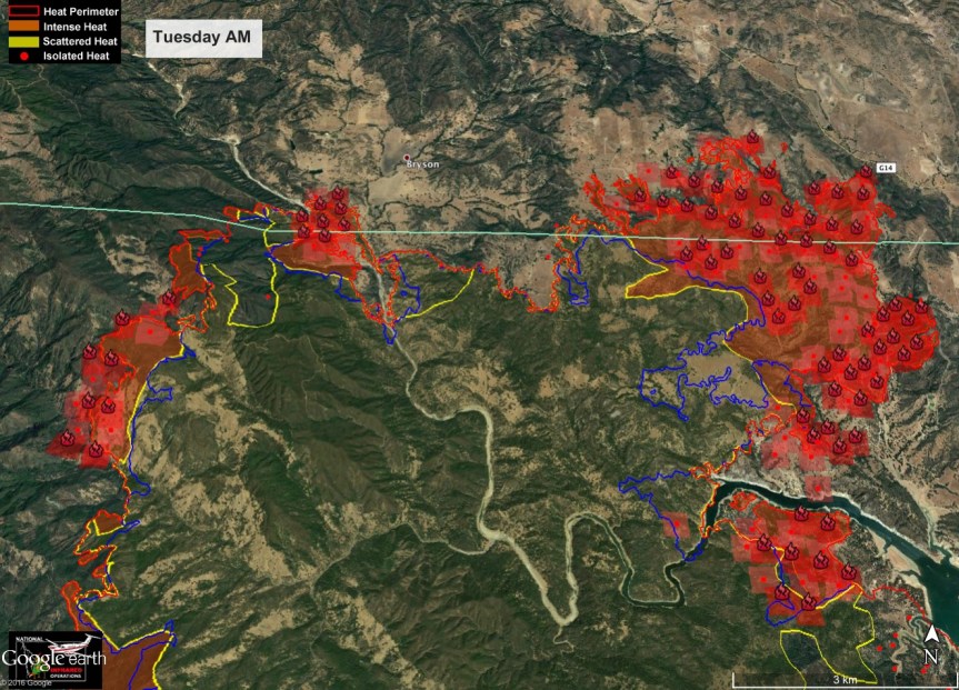
7:00 am – Here is the IR map for today to get us started. I need to go start my coffee (TMI, right?) and then I’ll be back Intel gathering. CAL FIRE reported Tuesday morning that the Chimney Fire grew nearly 4,000 acres overnight to 37,101 acres burned. Containment of the blaze remains at 35%. Here is the link to the IR Topo map:
Topo IR PDF Map Link


