Storm Report, 1/8/19

2:30 pm – from a comment below that I think is important to repeat up here:

Sorry, No Tourist Tuesday today. I wrote it last night, with links to the research, but this morning, it was gone. I either …

Hi Folks, so the pattern change i spoke of last month is taking shape, however the storm track pathway is more typical ( may i say “normal” for once!) from a more northerly angle rather than pineapple express storms or atmospheric river storms which have been our pattern the last few years. One major teleconnection enforcing this northerly flow is the Madden Julian Oscillation is rather locked up in the West equatorial Pacific and is not propagating as quick or even at all into the central and eastern Pacific regions but could start shifting in couple weeks. The precipitation composites affiliated with this phase is generally dry for us so its looking more and more likely our wet pattern could stick around for a while. Looking down the road the wet pattern continues thru at least next Tuesday with moderate to weak storms hitting every couple days. Moreover, looking even further out things get real intetesting around Jan 25-28th period when we could see our first real big storm of the likes we havent seen in a while and could be one to seriously prepare for! These smaller storms are priming the land for landslides and river flooding and by the end of the month saturated lands could begin to impact our hills stability and our river bank capacities. Some are calling this Winter “The little Nino that could” and might be fitting term by mid February.

Sorry, No Tourist Tuesday today. I wrote it last night, with links to the research, but this morning, it was gone. I either didn’t save a draft or put it in the queue and now the information it was based on was closed out. So, today will be all about the upcoming storm.

e0620f04-b532-4502-90c6-2699c87e3063

Storm Report & Highway Conditions, 1/7/19

This is part of what NOAA says we can expect:

Long story short, we`ll continue to be under a wet pattern for at
least the next 7-10 days. As the rain accumulates and soils
saturate this week and into the weekend, will have to monitor for
an increasing risk of mudslides and debris flows. Also will need
to monitor for rising small streams and creeks.

8:45 am – Cal Trans is cleaning up between Ragged Point and Salmon Creek and will be cleaning up to Fuller’s and hopes to have the highway open by 10 am. Here are a couple photos from yesterday morning:

5:30 am – It was reported to me by an employee of Pacific Valley School that there was a “hard closure” near Salmon Creek around 11 pm, that several people tried to get through from Gorda and were not able to. I notified Cal Trans this am.

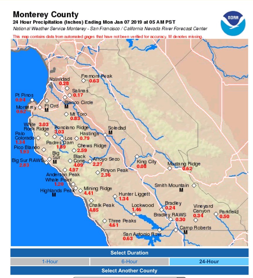
We got an astoundingi almost 5” of rain here in the last 24 hours.

1d616b3d-bb89-4526-84b5-f91baa81dbfb


Highway One is Closed

Subject: Re: Upcoming storm

All,

CHP has requested closing Hwy 1 as of 6 PM tonight due to rocks in the roadway. Big Sur is closing the North end at Fuller’s and Cambria is closing the South end at Ragged Point.

This will be a soft closure like we’ve done in the past and the gates at either slide are not going to be locked at this point. I’ll call Shane and get the CMS’s activated.

Please feel free to respond or call me if you have any questions at all.

Thanks.

Mud/Rock/Slide

Per the CHP. Note, the MM 32.60 is not 5 miles north or Esalen, but at Hot Springs Bridge between the north and South Gate.

00379 6:24 PM Mud/Dirt/Rock Sr1 / Esalen SR1 5 MI JNO ESALEN , MM 32.60 Monterey

No highway closure today

Both Mud Creek (PM 8.9) and Paul’s Slide (PM 21.6) sites looked good this morning and the forecast for today/tonight has gone down so there will be no preemptive closure today. Crews will assess again tomorrow.

Winter is here, there is a line of storms in the forecast, there is a possibility we may need to preemptively close Hwy. 1 with less than 48 hours’ notice. Crews will continue to assess the sites, monitor the forecast, and provide an update as conditions warrant.

Storm Report, Sunday, 1/6/19

3:45 pm – I just came across an excellent article by John Lindsey, a meterologist in SLO on several possible reasons why the storm door is now open. It is worth your time to read.

https://www.sanluisobispo.com/news/weather/weather-watch/article223980785.html

10:45 – From NWS – Radar indicates a strong cell near the Point Sur lighthouse. Heavy rain may cause localized flooding. Strong winds to 40 mph possible as well.

994acce0-f337-4136-b0a8-be07b6f11a09

Photo Sunday – Tenacious Tomatos

These guys are doing their damnest to produce fruit right up until the first snow. A week’s worth of below freezing temps, and they STILL hang on. In case you are wondering, my tomatoes of choice for up here are Champion, Celebrity, Ace, and Early Girl. All proven producers for my environment. This was taken on Friday, before the storm. I’ll pick all the remainder during the next break in the weather and let them finish indoors. They gave me a lot of salsa, tomato sauce, and BLTs.

89616284-6f1d-45d5-ae2f-d2f2489c3ee4

Photo Sunday, 1/6/19

From our trip to Hesperia. This was taken on the way home, 46 East a week ago Friday. Wish our roads were like this…sigh… (not straight, just deserted.)

D1B85163-3418-4A3D-8B66-73FDECDBE1F5

Temporary Closure of Highway One likely by Sunday 5 pm.

The storm forecast has changed and gone up significantly with heavy rain predicted Sunday evening and overnight, Jan. 6th into Jan. 7th. Crews will assess tomorrow morning (Sunday, Jan. 6) and continue to monitor the forecast.

There is a high likelihood Hwy. 1 at Mud Creek (PM 8.9) and Paul’s Slide (PM 21.6) will each close by 5 pm tomorrow, Sunday, Jan. 6.

An update will be provided by noon tomorrow after staff assessment is made.

Storm Report, 1/5/19

2 pm –

b19d9478-9247-4b6a-9a57-318493d26452

9:30 am – still a bit windy, but also a steady rain for the last hour or so. Loving the sound. Due to the generosity of a teacher at Pacific Valley School and her husband, I now have a truckload of firewood to  see me through these storms. I am feeling rich, so splurging with a little fire during the day, which I normally don’t do. Thank you Ellen & Bill. And thank you to Rock Knocker who delivered it and stacked it, much inside in my fireplace room so I don’t have to brave the cold, windy, rain.

5:45 am – from the NWS: “Those along the northern and central California coastlines, including the Bay Area, should keep their eyes open for strong to briefly severe thunderstorms, especially, later today. Severe thunderstorms may contain damaging winds, waterspouts, and tornadoes.”

I will add to this post as necessary throughout the day, but weather forecasters are saying “the storm door is open” and expect rain for much of this next week.