Coleman Fire on FHL

7:30 pm – Evacuations have begun for Pine Canyon(just south of King City). There are massive orders in the works right now. “The fire is well established in to Reliz Canyon, has burned in to the Ventana Wilderness on the LPF, and is threatening Pine Canyon. The majority of the resources are focusing on structure protection and are not really engaging on the wilderness portion yet.”

From Monterey Fire Service;

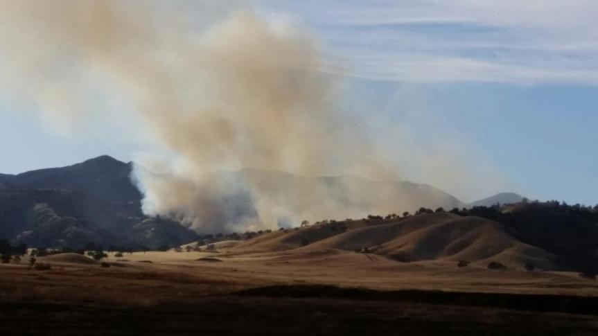
“This fire, the “Coleman Fire,” being near Coleman Reservoir, in Fort Hunter Liggett, began today at about 1500 hours and is in the northern Fort Hunter Liggett, Los Padres Forest area. The photo was taken from Highway 146 southeast of Soledad at about 1615 hours.

At 1830 hours, a local government Type 3 strike team, Strike Team 2175 C, was requested for an immediate need to the fire. The strike team includes Salinas, North County, POM FD, Monterey County Regional, and Marina FD, with Strike Team Leader 5301 from Salinas FD.

At 1835 hours, a second immediate need type 3 strike team, Strike Team 2176 C was requested by the U.S. Forest Service to the same fire. The strike team includes Monterey FD, Seaside FD, Salinas FD, and Monterey County Regional FD with the Strike Team Leader Chief 6202 from Seaside FD.

Also, the southwest portions of Reliz Canyon Road and Pine Canyon Road may be impacted by the fire. The fire is nearing 2000 acres with 0% containment. Structures are threatened.”

View of the Coleman Fire from Cahoon Summit, CV by Craig Matthews

image6:30 pm – still trying to get details, but at least 8 tankers on this, and MoCo did a large call out of all available units.

4:30 pm – fire making a run, up to 2,ooo acres, due East of Junipero Serra Peak. Six tankers and 2 Helios working out of Paso on it so far. I’ll keep posting every hour for a while. Next post around 5:30 pm.

image
Default CA-FHL-Coleman
Location: Coleman Canyon area of FHL, Lat and Lon from AA: 36.113 x 121.289
Acres: 40
ROS: Rapid
ROC: initially 3 acres at the toe of a slope, fire grew to 40 acres with long range spotting in grass and brush.
Structures: are not currently threatened
Special Hazards:
Resources: BC12LPF CRW3LPF DIV1LPF E15LPF 4X4 E18LPF E319LPF E335LPF E338LPF4X4 HEL527LPF PAT17LPF Q PAT41ALPF WT3LPF, 6 Air Tankers on order and 2 Copters.
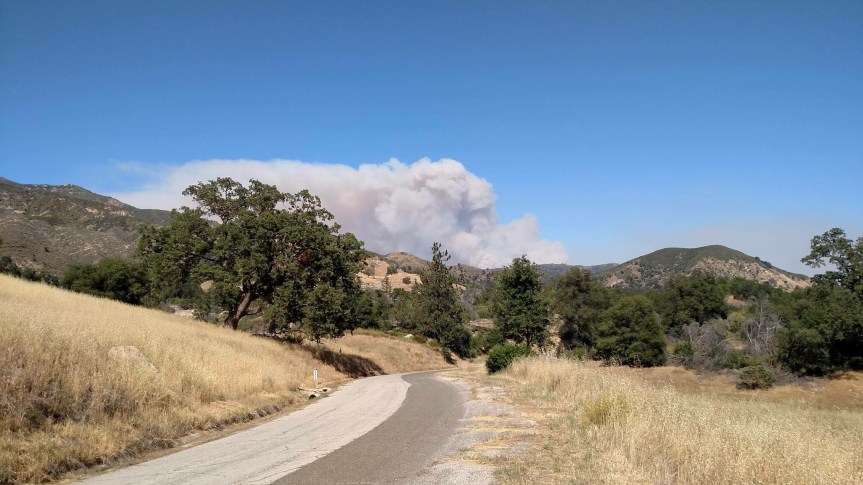
Photo above is from Brian Mack.

Fire currently up to 2000 acres, in no time. Firefighters on the scene say it is running! Firefighters familiar with this area say this is nasty country and they expect it to go extended and anticipate 20,000 acres.


Stoney Fire, 6/4/16

Here is another shot of the fire from Geri Kavanagh-Baird from 8 pm last night. Looks like they are getting a handle on it. The photo is so dramatic due to the setting sun and the smoke it is filtered through. Fires do make for some awesome photos. Unless something untoward happens, this will be my last post on this fire.

image


Stoney Fire, 6/3/16

3:00 pm – Strike Team SBC 1538C plus E 312, 318,323,332,351, plus battalion 513 assigned to Stoney. KRN ST reassigned from Chimney to Stoney.

1:00 pm – Per South Ops, the fire is 250 acres and 15% contained. Moderate ROS. Planned burning ops for today will cause acreage to increase to about 3800 acres.

8:30 am – Intel: “What I do know is they were attempting to get dozer line around, indirect, and then to fire it out. If that was/is successful, it would be approximately 5,000 acres. If the weather does what it is predicted to do today, that should be a very challenging line to hold. The ignition probability is about 100% out there right now. Anyway, that was the word I got”

Photos of Stoney Fire at mouth of Wizard Gulch taken last night by Geri Kavanagh-Baird

imageimage

As of 4:30 am the fire has grown to 500 acres.

“Updated spot for Friday. Estimated acreage around 500 acres. Very hot and dry.

http://spot.nws.noaa.gov/cgi-bin/spo…60603.STONY.01

In addition to Fort Hunter Liggett RAWS this nearby weather station is likely more representative of the weather on the fire.

http://mesowest.utah.edu/cgi-bin/dro…HPEC1&time=GMT

Last MODIS heat images are from about 10 pm, overnight heat signature has cooled considerably. Will see how it behaves with another day of 100 plus heat and single digit RH.”

Wildfires, 6/2/16

We have two happening, and one seems to be getting some legs – that is the Stoney Fire in FHL. One firefighter had this to say:

“Apparently, this fire is running up to Wizard Peak. It is definitely heading toward the LP and the initial crews on scene have pulled back due to intensity.” 6 Tankers are on this and 3 heliocopters, and strike teams have been ordered. It was 40 acres at start, don’t know what it is now.

The second one is a grass fire up at Highway One and Highway 156. I’ll be watching both, but my interest will be in the Stoney Fire. I can already see smoke haze on the horizon over the ocean. Heads up, all.

Small Wildfire, FHL Nacimiento RD.

05/30/2016 12:28 FHL-1438
Wildfire Nacimiento Fergusson Rd . Cpt1B Q DIV1LPF E16LPF 4X4 E319LPF . light flashy/brush 4 to 5 (acres)

300 Acre Fire East of Soledad

8;45 pm – local media reports it is 4000 acres

8:30 pm – I have reports it is up to 1000 acres.

6:00 pm – air attack (A/A) estimates, conservatively, that fire is holding at 800 acres. At 7 pm, it was up to 900 acres. The amazing photo below was tweeted by Cal Fire. It is not mine. No photographer credit was given, but this is a great example of HDR.

image

5:30 pm –
5:28 PM 12 [39] CDF ADV FIRE IS ONLY AFFECTING WEST SIDE OF PINNACLES AT THIS TIME – NOT AFFECTING THE EAST SIDE // FIRE IS PUSHING SOUTH AND EAST – MAY NOT HIT THE PINNACLES FULLY // EVACUATION IS NOT IN EFFECT YET – BUT IF ANYONE FEELS THREATENED – PER CALFIRE, ADVISE THEM TO LEAVE THE AREA

here is a still from a KION news vid:


5:15 pm = second fire 1.3 miles south of the south end of the main fire.

5:00 pm – 7 tankers on the fire already and 6 more dozers just ordered.

4:30 pm – SOLEDAD, Calif. – Cal Fire crews are attempting to contain a 300-acre vegetation fire off Metz Road and Blue Jay Lane, east of Soledad.

Officials say the blaze began around 3:30 p.m.

The fire has not yet been contained. No homes or structures are in danger but there is a threat to power transmission lines.

The cause is currently unknown.

Satellite update

Finally have scheduled a service call for Tuesday between 11-2. Cell has been very unreliable, so until Tuesday, enforced internet withdrawals. Frankly, I needed this.

BTW, 50 acre wildfire on FHL, but reported in the “flat part’ (aka Stoney Valley?) so probably not a threat. I’ll find a way to report if necessary.

Wildfire, FHL

4;30 pm – It started this afternoon, but I have taken the day off (it IS my birthday) and was in town. I am informed that they would not let people through Nacimiento-Fergusson RD. It was reported as only 2-3 acres in Stony Valley, and it is just May, so probably all is fine. I will post further when I get home, if necessary.

Wildfire Report, 5/18/16

8:00 pm – the “Bob” Fire (Camp Roberts) is holding at 1500 acres and is 40% contained. Hopefully, as often happens, it will “lay down” tonight. The smoke drift is visible here on the South Coast, particularly over Willow Creek.

6:30 pm – A/A is reporting 1500 acres ad making good runs. Also, from the scanner: “Just heard SLO send two rigs up to M/C  (Monterey County) for a veg fire on Interlake Rd. with a cross of San Antonio Rd. …engs. 3472 an 3481 have been sent up to it” Bob is making its way in a different direction, toward San Marco RD.

6:00 pm – 6 tankers working it now

4:50 pm – 600 acres and it jumped the Nacimiento River

4:20 pm – 500 acres. Photos by viewers of SLOStringer

image

3:30 pm – Currently there are two fires burning in Atascadero – one structure and one veg. Equipment and A/A pulled off the veg fire for a new fire burning on or near Camp Roberts. One report is it is on Avery RD. And Bivwac RD. One report from an observer:
“This thing has already generated pyrocumulus clouds…. uneven-sounding firefight…. I.C. requesting five more engines…. and just told SLU that the fire has jumped the river (I assume the Nacimiento River, not the Salinas River) and “has nothing to stop it.”


Defensible Space

Fire Safe Council Recommends Reducing Vegetation Now (I started the weed eating process just a few days ago … Takes a while)

To Help Avoid Catastrophic Wildfires This Summer

The rainy season is coming to a close on the Central Coast, but recent rains have helped sprout denser-than-usual grass, weeds and brush, which can serve as volatile fuel for dangerous wildfires.

The Fire Safe Council For Monterey County is advising that residents and businesses maintain defensible space around their homes and buildings to help protect lives and property from wildfires.

Now is the time to reduce vegetation around structures, before the days get drier and warmer, and the summer wildfire season arrives. By preparing early this spring, it can make a huge difference in the event of a fire in the summer months.

California law (PRC 4291) generally requires owners and lessees of structures located in areas subject to wildfires to reduce vegetation within 100 feet of the structures.

This area of reduced vegetation around structures is part of what is called “defensible space,” which also includes areas along emergency access routes and other places where vegetation should be reduced to help protect lives and preserve the environment.

You can download CAL FIRE’s Guidelines For Creating Defensible Space by clicking here: Guidelines

CAL FIRE encourages communities to create community-wide defensible space. The Fire Safe Council For Monterey County can help residents accomplish that goal by providing assistance with grant applications to obtain funds to help make the community more fire safe.

The council can act as a “fiscal sponsor” for a fuel reduction grant by receiving and administering grant funds for home owner associations and groups of neighbors. This makes it possible for groups that are not incorporated as tax-exempt organizations to apply for and receive grants.

You can download the council’s new tri-fold brochure by clicking here: Brochure

For more information on creating defensible space or help obtaining grants, contact the Fire Safe Council at any of the following:

2221 Garden Road, Monterey, CA 93940
(831) 333-2600 (Office)
(831) 333-2660 (Fax)
http://www.firesafemonterey.org
info@firesafemonterey.org

Copyright © 2016 Fire Safe Council For Monterey County, All rights reserved.
You are receiving this email because you have shown interest in the Fire Safe Council For Monterey County and/or the Monterey County Community Wildfire Protection Plan. To be removed from FSCMC’s email list please use the unsubscribe link below.