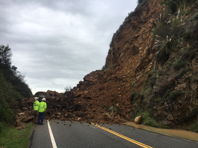
Weather & Road Conditions, 1/22/17

8:30 am – I will post the road conditions from the Cal Trans daily update when received, but it is safe to assume Highway One is still closed in a number of directions.

CHP website indicates mud/rock/slides at River Inn, Lighthouse, and Hurricane Pointing – in addition to the ones we know of at Burns Creek, Paul’s Slide, and Mud Creek. Oh, joy. What fun today.

I just received an emergency flash flood warning for my area – which is probably for my Big Sur Zip Code. If you haven’t signed up, you should. I receive a text as well as a voice mail.

Anderson (Burns) Closure-LOCALS WILL BE CITED, 1/21/17

img_1838

Photo sent by David Halterman.

+++EMERGENCY VEHICLES ONLY NOW ALLOWED THRU ANDERSON CLOSURE–LOCALS WILL BE CITED BY CHP AND NOT ALLOWED TO TURN AROUND+++
State Route 1 CONTINUES
closed from Ragged Point (SLO PM 72.87) to Anderson Canyon Bridge (MON PM 35.4) due to rock/mudslides in multiple locations. The newest slide is located at PM 35, requiring the closure to move from Lucia (PM 23) to Anderson Canyon Bridge (PM 35.4).

LOCALS AND GUESTS MAY TRAVEL SOUTH ONLY TODAY AND TOMORROW, SUNDAY FROM 7 AM UNTIL 3 PM , FROM ESALEN (PM 32.4) TO BE ESCORTED BY A PLOW TRUCK AROUND PAUL’S SLIDE (PM 21.6) IN ORDER TO TAKE COUNTY ROAD “NACIMIENTO FERGUSON” (PM 18.90) SOUTH, AS THERE IS AN ACTIVE SLIDE AND FULL CLOSURE AT MUD CREEK (PM 8.8) . NO NORTHBOUND TRAFFIC WILL BE ALLOWED.

Cal Trans Photosi from Friday 1/20/17:

img_1839img_1840

And from the CHP:
6:39 AM 3 [5] UNKWN EST TIME TO OPEN
6:39 AM 2 [3] NACIMIENTO-FERGUSSON IS OPEN TO LCL AND ER TRAFFIC ONLY THRU HUNTER LIGGETT
6:39 AM 1 [2] HWY 1 IS CLOSED F/MPM 42 (FULLERS) DOWN TO RAGGED PT (SLO COUNTY)

Highway One Closure Update #2, 1/20/17

Here is another view:

img_1837


State Route 1 IS NOW closed from Ragged Point (SLO PM 72.87) to Anderson Canyon Bridge (MON PM 35.4) due to rock/mudslides in multiple locations. The newest slide is located at PM 35, requiring the closure to move from Lucia (PM 23) to Anderson Canyon Bridge (PM 35.4).

LOCALS AND GUESTS MAY TRAVEL SOUTH ONLY UNTIL 4 PM TODAY, FROM ESALEN (PM 32.4) TO BE ESCORTED BY A PLOW TRUCK AROUND PAUL’S SLIDE (PM 21.6) IN ORDER TO TAKE COUNTY ROAD “NACIMIENTO FERGUSON” (PM 18.90) SOUTH, AS THERE IS AN ACTIVE SLIDE AND FULL CLOSURE AT MUD CREEK (PM 8.8) . NO NORTHBOUND TRAFFIC WILL BE ALLOWED.

Motorists may travel south on Hwy. 1 from Carmel to Julia Pfeiffer Burns State Park (PM 35.84) or travel north from Cambria to Ragged Point.

In addition there is a full closure on Hwy. 1 at Mud Creek (MON PM 8.88) due to a mud/rock slide.

ROADWAY IS NOT PASSABLE IN BETWEEN THE CLOSURES AT THIS TIME.

Another update will be provided TOMORROW by noontime, Saturday, Jan. 21 or sooner if conditions change.

Susana Z. Cruz nature-flower-blue-motif[1]
Caltrans District 5
Public Information Officer/

Highway One Closure Update

img_1834

(Cal Trans Photo of new slide, viewed from North.) View from South below

New Slide Last Night between JPBurns and Burns Creek (MM 35) moves closure from Lucia (for Paul’s Slide) To Fuller’s for this one. Mud Creek still shut also. In other words, you can’t get there from here, or from pretty much anywhere for now. Cambria to Ragged Point still open and Carmel to Coast Gallery open for the time being.

img_1835

View from South of New Slide by Amber Rose who works at Lucia Lodge.


Cal Trans Update, 1/19/17

Attached is a picture from yesterday morning (Wednesday, Jan. 18) of the Nepenthe Slide Clean Up (PM 43.91)

img_1833

HERE IS TODAY’S HWY. 1 CLOSURE UPDATE FOR THURSDAY, JAN. 19:

State Route 1 continues to be closed from Ragged Point (SLO PM 72.87) to Lucia (MON PM 23.00) due to rock/mudslides in multiple locations.

Motorists may travel south on Hwy. 1 from Carmel to Lucia or travel north from Cambria to Ragged Point.

In addition there is a full closure on Hwy. 1 at Mud Creek (MON PM 8.88) due to a mud/rock slides within the existing boundary of this closure.

For the time being, Hwy 1 is open to LOCAL RESIDENTS traveling south from Monterey who can safely get around via escort/flagger around the closure at Paul’s slide (MON PM 21.6) down to Gorda (PM 10) between 8 am until 4 pm.

Another update will be provided tomorrow afternoon, Friday, Jan. 20 or sooner if conditions change.

Slide Removal near Nepenthe

Good morning everyone,

This is NOT the noontime update, but rather, an new FYI.

There is 1-way controlled traffic due to slide removal SR-1 near Nepenthe (North entrance), MON-1-43.91 is expected to last until 2 pm today. Caltrans lead worker says rain is coming around 10-11 am today so closure probably won’t last until 2pm. I’ll provide the regular update this afternoon.

Susana Z. Cruz
Caltrans District 5
Public Information Officer/

Cal Trans Update, 1/17/17/

CALTRANS
HIGHWAY 1 UPDATE
January 17
2:30 PM

Good afternoon,
This is an aerial of Mud Creek (PM 8.8), our active slide with a full closure in effect . Our local Geotech is meeting with Geotech from San Francisco today to find the best fix for Mud Creek (PM 8.8) It may be a longer than desired process, but we’re looking for the best and safest solution.

img_1830

This is just the very bottom portion of the slide area. For those interested, I have a google earth screen shot, but for most of us, it is difficult to realize what one is looking at. I will see if I can learn to annotate it with what Rock Knocker has to say – will be in steep learning curve for me, so don’t look for it tonight, and maybe not even tomorrow.

FROM BIGSURKATE AND ROCK KNOCKER – NOT OFFICIAL CAL TRANS INFO –  What a lot of people don’t realize when they see that slide on the mountain or on the highway, is that this is not the true problem. There is movement pushing from way up above that can be seen on google earth or a very long climb or by helicopter. This is just the tip of the proverbial iceberg.

THIS AFTERNOON’S UPDATE REMAINS THE SAME AS THIS MORNING:

State Route 1 continues to be closed from Ragged Point (SLO PM 72.87) to Lucia (MON PM 23.00) due to rock/mudslides in multiple locations.

Motorists may travel south on Hwy. 1 from Carmel to Lucia or travel north from Cambria to Ragged Point.

In addition there is a full closure on Hwy. 1 at Mud Creek (MON PM 8.88) due to a mud/rock slides within the existing boundary of this closure.

For the time being, Hwy 1 is open to LOCAL RESIDENTS traveling south from Monterey who can safely get around through the an open lane at Paul’s slide (MON PM 21.6) down to Gorda (PM 10) until 4 pm this and each afternoon.

There are no crews currently escorting at Paul’s Slide as all crews are working down at Mud Creek. Another update will be provided tomorrow afternoon, Wednesday, Jan. 18.

We will continue to work with you in maintaining the roadway safely open as much as possible. The forecast says Big Sur is expecting rain beginning tomorrow Wednesday, Jan. 18 through next Tuesday, Jan. 24, so no telling how Hwy. 1 will fare. We thank you for your patience, cooperation and understanding.

Susana Z. Cruz
Caltrans District 5
Public Information Officer/

Interactive Map, South Coast Slides and Mile Markers

A friend spent a lot of hours creating this map for my readers. What I will do is post the jpeg version first, so you can visualize, and then the link to the interactive pdf version below it. Eventually, there will be three maps – South, Central, and North. These will also be included in the History of Highway One at the top of the page so they are easy to find. You could also print out a version to keep near your internet device.

big-sur-coast-map-south_01

This is very, very cool. My friend won’t let me give him credit, but what he did is dynamite! When you open up the pdf link below, you get a new tab in your browser that has the interactive map. When you click on one of the white boxes for the slide name, you will get the choice of a split screen showing the full map on one side, and the photos of that particular slide on the other screen. It is a great tool we will use often in the years ahead. Thank you, my friend. And Rock Knocker says: “Outstanding.”

big-sur-coast-map-south

MC Commercial?

4 pm – oops…Commercial moved off highway one as off 2:30 pm and up OCR at Molera

Around 10 am, on the way to town, it looked like they were setting up to do a MC Commercial on Bixby. There are cars, cops, etc. staging on the second turn out south of Bixby, and more staging, including motorcycles, at Notley’s Landing just south of Rocky Point. Nothing showing on CHP, but I witnessed them a little after 10 am. Be prepared. Will be heading back down later this afternoon, so will update when I get to River Inn.

Rain Report, 10/28/16

9:30 am – been quiet since 9 am, when I glimpsed a lot of blue sky before the clouds closed in on me. Big Sur Station reports 1.4″ of rain, a report of 1.1″ in Seaside Highlands, and another local reports the highway is clear from River Inn to Lucia. So far, so good, but several more storms to go, yet.

7:00 am – I woke at 12:30 am to the sound I had been waiting all day for – the patter of dogs and cats across my roof – or so my rain gauge told me. The rain rate was 1.23″/hour or well past the 1/2″ rate that triggers debris flow – raining cats and dogs is a favorite saying of my rain gauge. I was still up an hour later and noted that we had had that 1/2″. My worry began for my neighbors to the north and to the east, particularly Palo Colorado Canyon.

Eventually, I did get back to sleep and re-woke at 6:30 am. Now, the rain is soft and gentle, and I note no other periods of heavy rainfall while I slept. It is now 1.1″ since midnight. I check the CHP site and see roadway flooding notes all over Monterey County, particularly along highway 101, but none here? Really? Meredith Gafill commented on my post on FB of a problem by Lucia, but it is gone when I check. I will continue to keep an eye out and hope those of you who can will share reports with the rest of us. We have rain predicted on and off through Tuesday, so this could become a very long weekend, particularly near the burn scar of the Soberanes. Be safe, everyone.

Here are the 24 hour totals. Some automatic gauges did not work, thus an “M” for missing.

img_1621