
Much more ticketing, educating, and anguish for today. When will they ever learn? When will they ever learn? (Peter, Paul, and Mary – Where have all the flowers gone?)


Much more ticketing, educating, and anguish for today. When will they ever learn? When will they ever learn? (Peter, Paul, and Mary – Where have all the flowers gone?)
I just don’t understand this … It is hotter than Darwin, as dry as the Mojave and people are having campfires? What is wrong with people?? And people wonder why those of us who live here don’t want any dispersed camping? Being constantly on edge that someone is going to “accidentally” burn us out is nerve wracking. This is absolutely nuts. I give up. We can’t educate those who don’t want to be, and they WAY out number the ones who do.

I just went on WildCAD to check on things and saw that our local people were patrolling after dark last night and managed to find SEVENTEEN illegal campfires – four on Plaskett, and the rest on Nacimiento RD., South Coast Ridge RD. And Prewitt camp. Since campfires are now banned, if they gave out 17 tickets at $5000/each, that is $85,000 worth. It would probably fund two firefighters for a year, if we could keep the money. Regardless, that is 17 potential wildfires that were caught before they became an inferno, and this even with the Sherpa raging in the southern portion of the LPNF. Bob Baird, Forest Supervisor, Tim Short, District Ranger, Chip Laugharn, Asst Dist Fire Management, and our pals at PV and Nacimiento Stations, thank you from the bottom of my heart. I look forward to reading tonight’s statistics. I tried to copy and paste the data, but no go. Go to WildCAD-LPNF to view for yourself.
June 7, 2016 8:00 AM
Start Date: June 4, 2016 Size: 2,340 acres
Containment: 15% Injuries: 0
Estimated Containment Date: 6/18/2016 Total Personnel Assigned: 850
Cause: unknown Structures Destroyed: I (other minor)
Current Situation: Fire crews made good progress again yesterday. The Coleman Fire grew very little. Most of the smoke on the fire was from interior islands burning out in the northeast corner of the fire above Pine Canyon. Crews mopped-up and patrolled the fireline throughout the night on the east side of the fire. Last night relative humidity reached as high as 70 percent on two-thirds of the fire.
Where possible, direct line construction will continue today. Additional crews have been added to the portion of the fire that is burning in the Ventana Wilderness area where there is still a significant amount of open line that needs to be completed. This area is very steep and remote and line production is slow and difficult. Mop-up and patrol will continue on the south and east side of the fire. Line construction will continue on the north side of the fire. Air support from both air tankers and helicopters is available to assist ground crews as needed.
The Coleman Fire is under Unified Command between Fort Hunter Liggett, CAL FIRE and the Los Padres National Forest.
Change in Fire Size: The reduction in the fire size from 3,200 acres to this morning’s acreage of 2,340 acres is due to more accurate mapping. The fire area was flown by an airplane with an infrared camera. The infrared map and field observations have allowed for a more accurate map of the fire perimeter.
Fire Weather: A high pressure system will remain over the fire area again today. It will be another hot and dry day with temperatures in the mid 90’s and winds out of the northwest. Relative humidity will remain low in the lower teens. Tonight temperatures will be in the mid 50’s with relative humidity reaching 70 percent below 1800 feet in elevation.
Evacuations: Residents in the Upper Pine Canyon, Monroe Canyon and Reliz Canyon are under an advisory. If needed, an evacuation center will be open at the Grace Lutheran Church at 205 Canal Street in King City.
Closures: Road closures on Reliz Canyon and Upper Pine Canyon remain in effect.
Click here for Public Information Map
Note: The infrared maps below show only estimated heat acres based on heat signature only and are not the official acreage which is currently 2,340.
Click here for IR Ortho Map
Click here for IR Quad Map
Click here PDF downloadable version of this update
###
Want to change how you receive these emails?
You can update your preferences or unsubscribe from this list
This email was sent to kwnovoa@mac.com
why did I get this? unsubscribe from this list update subscription preferences
CIIMT1info · Wildland Fire Information · California, Ca 90026 · USA
Email Marketing Powered by MailChimp
Photos by Ray Martorano take at Paso Robles Airport yesterday. I don’t know what specific kinds of planes these are:\
7:30 pm – Evacuations have begun for Pine Canyon(just south of King City). There are massive orders in the works right now. “The fire is well established in to Reliz Canyon, has burned in to the Ventana Wilderness on the LPF, and is threatening Pine Canyon. The majority of the resources are focusing on structure protection and are not really engaging on the wilderness portion yet.”
From Monterey Fire Service;
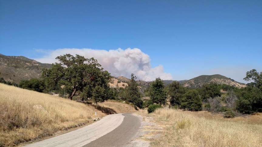
“This fire, the “Coleman Fire,” being near Coleman Reservoir, in Fort Hunter Liggett, began today at about 1500 hours and is in the northern Fort Hunter Liggett, Los Padres Forest area. The photo was taken from Highway 146 southeast of Soledad at about 1615 hours.
At 1830 hours, a local government Type 3 strike team, Strike Team 2175 C, was requested for an immediate need to the fire. The strike team includes Salinas, North County, POM FD, Monterey County Regional, and Marina FD, with Strike Team Leader 5301 from Salinas FD.
At 1835 hours, a second immediate need type 3 strike team, Strike Team 2176 C was requested by the U.S. Forest Service to the same fire. The strike team includes Monterey FD, Seaside FD, Salinas FD, and Monterey County Regional FD with the Strike Team Leader Chief 6202 from Seaside FD.
Also, the southwest portions of Reliz Canyon Road and Pine Canyon Road may be impacted by the fire. The fire is nearing 2000 acres with 0% containment. Structures are threatened.”
View of the Coleman Fire from Cahoon Summit, CV by Craig Matthews
 6:30 pm – still trying to get details, but at least 8 tankers on this, and MoCo did a large call out of all available units.
4:30 pm – fire making a run, up to 2,ooo acres, due East of Junipero Serra Peak. Six tankers and 2 Helios working out of Paso on it so far. I’ll keep posting every hour for a while. Next post around 5:30 pm.
Default CA-FHL-Coleman
Location: Coleman Canyon area of FHL, Lat and Lon from AA: 36.113 x 121.289
Acres: 40
ROS: Rapid
ROC: initially 3 acres at the toe of a slope, fire grew to 40 acres with long range spotting in grass and brush.
Structures: are not currently threatened
Special Hazards:
Resources: BC12LPF CRW3LPF DIV1LPF E15LPF 4X4 E18LPF E319LPF E335LPF E338LPF4X4 HEL527LPF PAT17LPF Q PAT41ALPF WT3LPF, 6 Air Tankers on order and 2 Copters.
Photo above is from Brian Mack.
Fire currently up to 2000 acres, in no time. Firefighters on the scene say it is running! Firefighters familiar with this area say this is nasty country and they expect it to go extended and anticipate 20,000 acres.
3:00 pm – Strike Team SBC 1538C plus E 312, 318,323,332,351, plus battalion 513 assigned to Stoney. KRN ST reassigned from Chimney to Stoney.
1:00 pm – Per South Ops, the fire is 250 acres and 15% contained. Moderate ROS. Planned burning ops for today will cause acreage to increase to about 3800 acres.
8:30 am – Intel: “What I do know is they were attempting to get dozer line around, indirect, and then to fire it out. If that was/is successful, it would be approximately 5,000 acres. If the weather does what it is predicted to do today, that should be a very challenging line to hold. The ignition probability is about 100% out there right now. Anyway, that was the word I got”
Photos of Stoney Fire at mouth of Wizard Gulch taken last night by Geri Kavanagh-Baird

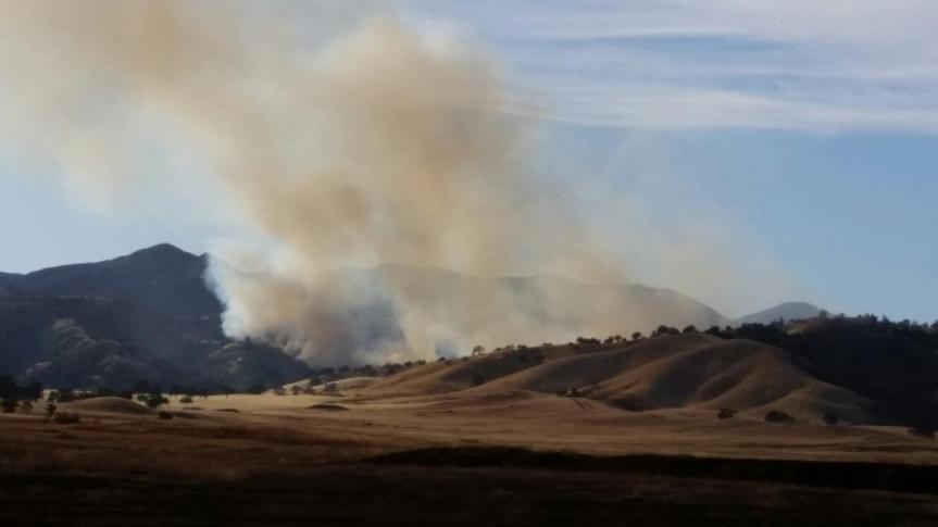
As of 4:30 am the fire has grown to 500 acres.
“Updated spot for Friday. Estimated acreage around 500 acres. Very hot and dry.
http://spot.nws.noaa.gov/cgi-bin/spo…60603.STONY.01
In addition to Fort Hunter Liggett RAWS this nearby weather station is likely more representative of the weather on the fire.
http://mesowest.utah.edu/cgi-bin/dro…HPEC1&time=GMT
Last MODIS heat images are from about 10 pm, overnight heat signature has cooled considerably. Will see how it behaves with another day of 100 plus heat and single digit RH.”
We have two happening, and one seems to be getting some legs – that is the Stoney Fire in FHL. One firefighter had this to say:
“Apparently, this fire is running up to Wizard Peak. It is definitely heading toward the LP and the initial crews on scene have pulled back due to intensity.” 6 Tankers are on this and 3 heliocopters, and strike teams have been ordered. It was 40 acres at start, don’t know what it is now.
The second one is a grass fire up at Highway One and Highway 156. I’ll be watching both, but my interest will be in the Stoney Fire. I can already see smoke haze on the horizon over the ocean. Heads up, all.
05/30/2016 12:28 FHL-1438
Wildfire Nacimiento Fergusson Rd . Cpt1B Q DIV1LPF E16LPF 4X4 E319LPF . light flashy/brush 4 to 5 (acres)
8;45 pm – local media reports it is 4000 acres
8:30 pm – I have reports it is up to 1000 acres.
6:00 pm – air attack (A/A) estimates, conservatively, that fire is holding at 800 acres. At 7 pm, it was up to 900 acres. The amazing photo below was tweeted by Cal Fire. It is not mine. No photographer credit was given, but this is a great example of HDR.

5:30 pm –
5:28 PM 12 [39] CDF ADV FIRE IS ONLY AFFECTING WEST SIDE OF PINNACLES AT THIS TIME – NOT AFFECTING THE EAST SIDE // FIRE IS PUSHING SOUTH AND EAST – MAY NOT HIT THE PINNACLES FULLY // EVACUATION IS NOT IN EFFECT YET – BUT IF ANYONE FEELS THREATENED – PER CALFIRE, ADVISE THEM TO LEAVE THE AREA
here is a still from a KION news vid:
5:15 pm = second fire 1.3 miles south of the south end of the main fire.
5:00 pm – 7 tankers on the fire already and 6 more dozers just ordered.
4:30 pm – SOLEDAD, Calif. – Cal Fire crews are attempting to contain a 300-acre vegetation fire off Metz Road and Blue Jay Lane, east of Soledad.
Officials say the blaze began around 3:30 p.m.
The fire has not yet been contained. No homes or structures are in danger but there is a threat to power transmission lines.
The cause is currently unknown.