
8:00 pm – I didn’t post this morning’s facts sheet, because it didn’t add anything we didn’t already know. This one has some new information that I think is worth sharing. It is two pages.


8:00 pm – I didn’t post this morning’s facts sheet, because it didn’t add anything we didn’t already know. This one has some new information that I think is worth sharing. It is two pages.
This is best of breed interactive mapping from the folks at MappingSupport.Com.
Kate is resting for another full day of fire blogging tomorrow but wanted to make this map available to her readers. I believe the blue line is an educated guess at the larger fire potential.

The map below was submitted to the blog by a Hot Shot crew member. This is for viewing purposes as much of the information has been disseminated and distributed throughout the day.

First red paragraph ORDERS; Second red paragraph WARNINGS

The Soberanes Fire began July 22, 2016, at 8:48 a.m. The fire is approximately 38,007 acres and remains at 15% containment as of this morning. Full containment is expected August 31. The fire is in Unified Command between the U.S. Forest Service and Cal Fire Incident Management Team 4.
The fire continues to burn in steep, rugged and inaccessible terrain. Warm and dry conditions will continue. The fire remained moderate overnight. A state of emergency has been declared by the Governor. The cause of the fire is under investigation.
Approximately 5,343 personnel are assigned to the incident, including 546 engines, 103 hand crews, 71 dozers, 46 water tenders, 16 helicopters and six air tankers.
Fifty-seven homes and 11 outbuildings have been destroyed in the fire, and there are currently 2000 structures threatened. Evacuation orders have been lifted for Riley Ranch Road, Red Wolf Drive, Corona Road, and all of Carmel Highlands. Evacuation orders remain in place for a number of areas adjacent to the active firelines, and evacuation warnings are in place for communities in proximity to the fire. An evacuation center has been established at Carmel Middle School. All California State Parks from Point Lobos State Natural Reserve through Julia Pfeiffer Burns State Park are closed until further notice.
A Forest closure order is in place for the northern Monterey Ranger District that prohibits public entry. The closure order has been extended south to the Nacimiento-Fergusson Road and additional law enforcement capacity is actively enforcing the order.
For the latest on the Soberanes Fire, visit http://inciweb.nwcg.gov/incident/4888/.
Forest Service Shield
Andrew Madsen
Public Affairs Officer
Forest Service
Los Padres National Forest
p: 805-961-5759
f: 805-961-5729
andrewmadsen@fs.fed.us
6750 Navigator Way, Suite 150
Goleta, CA 93117
http://www.fs.usda.gov/lpnf
USDA LogoForest Service TwitterUSDA Facebook
Caring for the land and serving people
The Soberanes Fire incident base is located on the Rancho Canada Golf Club property off Carmel Valley Road. The two golf courses on the property are in the process of being shut down and donated to conservation concerns. In the meantime the property will act as a perfect spot to house a couple of thousand or more firefighters and equipment. I was able to capture a few images from the periphery of the camp. These images give a slight perspective on the setting.
The ‘camp’ has only been in operation for 24 hours but in that short time has become a self contained city of its own. Security has been established on Carmel Valley Road and no one but authorized personnel can walk the property.

Fire Personnel Tents Along The Carmel River

Some Sleep In More Comfortable Accommodations

Chow Line

This Sand Trap Has Seen Its Final Days Of Play

Night One of Operation Of The Soberanes Incident Base, Carmel Valley.

To ZOOM in on a desktop computer – hold CONTROL and + (on mac COMMAND and +)
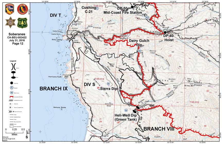
Operations Map
Legend

Public Information Map

Infrared Topo

Infrared with Satelite Image

Infrared Log
Weather Forcast
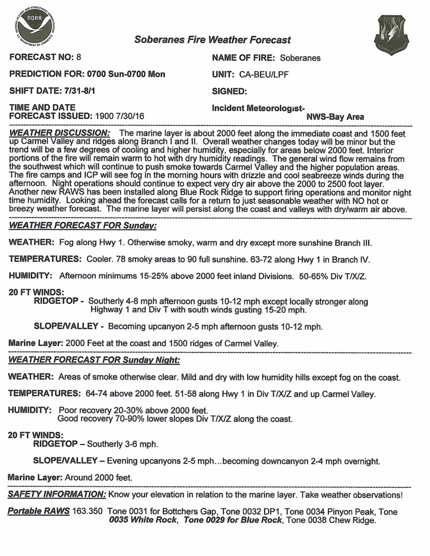
Fire Behavior Forcast
Dozer Index

Dozer Maps


Notes:
-Read more about the satellite heat detection here: xasauan today
-Adam Clark has provided an updated link for people to use if they don’t have Google Earth. You can find it here: Mapping Support (Black lines are completed Dozer lines and Blue lines are proposed Dozer lines, but they may not be current. Go to the Dozer maps for the most current info.)
-The weather information for the “blue WX rectangles” can be located at: MesoWest (link provided by Larry)
Scroll down to SC07 Central Coast. There are 6 IRAWS which stands for Incident Remote Automated Weather Stations. Each are labeled with a number and location. This page is a summary (refresh the page to get the latest observations) but there are hyperlinks to each station for more detailed information. UTC/GMT time zone is 7 hours ahead.
-Live Air Traffic can be found here: Flight Radar 24
An hour later and that plume from the south eastern edge is almost gone, and we’ve got this one from the south western edge. A burn out operation at the Golden Stairs south of Pico Blanco, maybe??

5:15 pm – current photo from my place:

4:30 – here is a visual of the area of the mandatory evac for Tassajara and parts of Cachagua (warning to the rest of Cachagua) Thanks to Lucas Ryan:

3:30 pm – A backfiring operation in the area of the Upper Preserve was successful to create that coveted “black line” of safety.
5 ATs out of Paso are on a flight path directly over my house. Yesterday there were 8 and several of them made their last run at dusk. Go pilots!! But put your safety first, please.
3:30 pm – from the 1215 hours MODIS flight sent by Jim Kasson:


3:00 pm – Evacuation Center reopened at CMS; Those on Evacuation Warnings in Cachagua and Tassajara, pay attention for the issuance of a Mandatory, if the need arises.
1:30 pm – EVACUATION CENTER AT CMS RE-OPENS
11:00 am – South Side of Pico Blanco facing Post Summit last night. Photo by Matt Peterson or Derric Oliver

10:00 am – Also from Cachuagua as a result of a back burn being undertaken:
From Cachagua Fire:
Cachagua Fire Chief Curry, along with Battalion Chief del Valle, are working with the Soberanes Fire Incident Management Team and the Monterey County Sheriff’s Office to hereby notify all residents of the Cachagua Fire Protection District that an evacuation warning is being issued.
Residents should know that the fire is approaching the boundary of the district and firing operations will begin today or tomorrow.
Smoke and flames will likely be visible within the Cachagua Fire Protection District as part of this operation. Smoke can be detrimental to the health of the young, old, and those with breathing or heart issues.
You may have received additional information via reverse 911 or from local media sources. We want to emphasize that this is an evacuation warning.
This is NOT a mandatory evacuation order.
For more information, you can contact Chief Curry
10:00 am – From San Clemente Rancho about 2 hours ago:
“To the south, the fire made amazing progress to the east yesterday burning through both the Big Pines and LIttle Pines areas of the Ventana…several miles at least! It is now backing down Blue Rock Ridge towards us (and the Cachugua).
To the West the Fire is making its way towards us via Ponciano Ridge and the South fork of the Black Rock Creek. It is now back out of the forest on our neighbors (the Lange’s & BLM) property.
Cal Fire has laid miles of hose line on the primary firebreak that Hank & I made but we still don’t have the air support everyone would like…the winds are predicted to shift, turning the smoke, not the fire) but that might come too late to help. Going to be a long next few days.”
Also hearing Evac warnings are to be given out to Cachuagua today.
****************
10:00 am – From Richard Cordova, Cal Fire PIO this morning.
Mount Manuel backfire planned for Monday, August 1, 2016
Cal Fire is planning a backfire on the eastern slope of Mount Manuel for Monday, August 1, if conditions are good. They are completing the dozer lines and advance work on this today. The plan is to back burn this section and join it with the larger fire. The timing is dependent on the weather. It may start in the morning but it could also be delayed until any time they determine the ideal conditions. Plan accordingly
****************
7:00 am – West Side of Pico Blanco, photo by Jen Smith

Photos by the Amazing Kodiak Greenwood of Pico Blanco and plume in background. Pico Blanco in this first photo is in the lower right. The burned ridge to the right and behind Pico Blanco is Skinner Ridge. The smoke-free mountain behind Skinner Ridge is Mt. Carmel. The big plume is rising from the Danish Creek watershed and Blue Rock Ridge (overlooking Cachagua) Per our resident expert, Keith Vandervere.


Per Keith, the one above is looking from Pico Blanco down Dani Ridge (with retardant stripe) toward the confluence of the forks of the Little Sur and the ocean. The smaller plume of smoke is coming from the burn out operation at the top of Serra Grade on the Old Coast Rd.

The second is of Moon’s property. Looks to me like most of the structures are still in the green and probably survived. Moon’s road is visible at the bottom. The summit of Serra Grade is on the right. From this photo I’m not sure if this burning is really part of the deliberate burn out or not.
6:00 am – Dawn has finally arrived and I can visually see what is happening. No plumes, smoke is clear – fog socking in most of the coast, but doesn’t look to be very high. I have had an hour to check in, catch up on mail, and the like, and now ready for coffee. It really is a nice day to sit and watch the sunrise from this amazing perch and enjoy a brief respite of calm before the frenetic day of fire reporting begins. Remember to take a moment for yourself, take a nap, if you can. They can do wonders to rejuvenate you. Current IR Topo map puts fire at 38.007 acres. Lucas is busy putting together our maps for us.
7:00 pm – Evening facts sheet

7:57 – Facts Sheet

Post and photos by Mike Morales, my assistant admin. He forgets to give himself credit, so I will. 😉
Most of the assembled fleet of helicopters at the helibase in Carmel Valley stayed on the ground yesterday. There were 13 helicopters on the ground when I viewed the setting near noon. There’s a buzz of activity surrounding these airships with mechanics, ground crew support personnel and fuel trucks. Most of the birds are on contract so each contracting company has their own support team. It adds up to quite a lot of action at the grass field, Carmel Valley Vintage Airport.


Cal Fire Copter 406 flew in and as it landed around eight men who looked more like a security detail than firefighters hopped out and formed a perimeter around the aircraft, facing outward. I thought a dignitary was about to disembark, none did. It’s likely this crew was preparing for a VIP tour at some point later in the day. It would not be surprising the see the governor or a high placed fed come in for a look through.

