Storm Watch, 1/19/10

Report from friend in town at 8:00 pm: “Hey Kate-
We just had the tv interrupted with a weather advisory/warning of severe thunderstorms, 60mph sustained winds and 1 inch diameter hail going thru Gorda and Lucia heading east…people were advised to take cover in a secure building and not near any windows.”

Frankly, I think this is late and exaggerated, and is probably the one posted at 7 pm, which suggested 1/2 inch, and which I got bb sized, which only lasted about 10 minutes. Granted, I have not checked nexrad in the last hour, and will do so, but unless I see another cell coming at us, I won’t be posting for a while

*MAKE SURE AND READ DAVE ALLEN’S REPORT ON CONDITIONS AS HE DROVE FROM CARMEL TO PACIFIC VALLEY SCHOOL AND HOME TODAY IN THE COMMENTS TO THIS POST.*

7:00 pm – Nexrad Radar shot. See that F-2?? That’s us, right here under it!

Here is what that means:

6:45 pm – the beginnings of rain, small hail, and a dog who hates lightning is panting with eyes dialated and wide open. My hearing-aid dog. Even though I can’t hear it. She can. Oh, now I can hear it, too!! Here it comes!

6:30 pm – from Dave Allen: “The alarm just went off on my weather radio. It was a Severe T-storm Warning about that cell I mentioned off the coast. They said that it is presently 5 miles off Cape San Martin, and warned about high winds, lightning, hail and such.”

5:30 pm, let me start rain totals for today over again. Yesterday afternoon’s .75 got counted twice, once in today’s total as well as in yesterday’s total, as it wasn’t dumped. (my bad) but not in the rest of the totals (week or season). In other words, today’s totals were still 2.75, but the two inches were this morning and the .75 came this afternoon, not last night and early morning. That brings this week’s total to an even 8 inches, and the season total to 34.6 inches. Thank goodness I write this stuff down on my calendar, huh?

3:20 pm – major lightning and thunder, just one, so far, but very bright, loud, close. Rain has begun again, and here’s the hail. Quick roll through, and gone in 10 minutes. Boy, our weather people called this one right on the money, didn’t they? There is a very long, detailed NOAA discussion issued at 3 pm today. Every interested party should read it. See links to the right.

3:00 pm – here it comes again. Here is current Nexrad:

2:30 pm – local went up to look at the slide on N-F Rd. and reports Cal-Trans has one piece of equipment there, but did not think it was big enough for the trees. She did not mention County one way or the other. Another local reported she came up the back side of N-F Rd. from 101 and was able to get through the few minor problems with her fully loaded low vehicle. Another local reports a tree down blocking Plaskett near the bottom. I’m guessing, with a relative degree of certainty, that there are a bunch more between it and me.

12:30 pm. I have confirmed with the USFS, PV Station that Nasty-Fergy is closed due to an “erosion problem.” I was informed that the County Road crews would get to it in the next “couple days.” Another Alm’s Ridge local was able to drive up Willow and all the way across the back side last night. Plaskett is probably impassable, but the USFS doesn’t have any information. Oh, and the good news is that at least some, if not all, of Big Sur Valley has power again.

It is dead quiet here, but the wind advisory remains in effect, with a high wind watch starting this evening. More of everything later tonight.

From the Monterey County Office of Emergency Services:

A WIND ADVISORY REMAINS IN EFFECT UNTIL 4 PM PST THIS AFTERNOON. A HIGH WIND WATCH REMAINS IN EFFECT FROM LATE TONIGHT THROUGH WEDNESDAY AFTERNOON.

* TIMING: STRONG SOUTH TO SOUTHEASTERLY WINDS WILL CONTINUE INTO THE AFTERNOON TODAY. SOUTHEAST WINDS WILL ONCE AGAIN INCREASE EARLY WEDNESDAY MORNING WITH THE STRONGEST WINDS EXPECTED IN THE MORNING AND EARLY AFTERNOON.

* WINDS: SOUTHEAST WINDS OF 20 TO 35 MPH WILL CONTINUE TODAY WITH LOCAL GUSTS AS HIGH AS 50 MPH. ON WEDNESDAY SOUTHEAST WINDS OF 25 TO 40 MPH WITH GUSTS AS HIGH AS 60 MPH ARE POSSIBLE.

* IMPACTS: WINDS THIS STRONG CAN LEAD TO PROPERTY DAMAGE. DOWNED TREES AND POWER LINES MAY RESULT IN POWER OUTAGES.

PRECAUTIONARY/PREPAREDNESS ACTIONS…

A WIND ADVISORY MEANS THAT WINDS OF 35 MPH ARE EXPECTED. WINDS THIS STRONG CAN MAKE DRIVING DIFFICULT…ESPECIALLY FOR HIGH PROFILE VEHICLES. USE EXTRA CAUTION.

A HIGH WIND WATCH MEANS THERE IS THE POTENTIAL FOR A HAZARDOUS HIGH WIND EVENT. SUSTAINED WINDS OF AT LEAST 40 MPH…OR GUSTS OF 58 MPH OR STRONGER MAY OCCUR. CONTINUE TO MONITOR THE LATEST FORECASTS.

11:00 am – a break in the weather, and nothing shows up on Nexrad for the next several hours. Hopefully, we won’t get any more until tonight.

10:00 am – power out in Big Sur Valley, per BSV source, and residents warned by PG&E that it is likely to be for an extended period of time.

9:30 am – live wires sparking in the middle of the road at Palo Colorado and Garapata Rd.

9:00 am – NOAA is warning of hail and thunderstorms possible today, wind, and the whole ball of wax. Santa Cruz is faring much worse than we are. Most of the roads in the San Lorenzo Valley are closed, including 9 by Ben Lomand.

8:30 am – either I misread it, or between first light and now we got another inch, for 2 inches overnight and this morning, 7.25 inches for the week, and 33.85 inches for the season.


Nexrad this morning. At least Big Sur is not in the red!

8:00 am – 1 inch overnight and this morning; 6.25 inches for the week (starting Sunday); and 32.85 inches for the season. Report from a friend in Pebble Beach at 6 am: “we are getting pounded…..terrific wind, massive thunder and wind like you wouldn’t believe.” And Dave Allen left Carmel for the difficult drive down the coast from Carmel to Pacific Valley School at 6 am and he will report when he arrives.

3:30 am – what am I doing awake? Listening to the rain, the wind, and what may be mixed hail, that’s what. I will get back to sleep, shortly, I hope, if the sounds of the storm allow. Metal roofs, necessary for living among the wildfires, amplifies the sounds of storms. Rain totals when it is light. Continued coverage through out the day. Be safe everyone!

Storm Watch 1/18/10, part II

8:00 pm – More heavy rain. The last one was short-lived, as was this one.

6:45 pm – HEAVY rain and hail. It is so loud I cannot hear my movie over it. Hopefully, just a cloud burst.

N-F RD. ROAD CLOSED – I received a report from a local that Nacimiento-Fergusson Rd. is closed on the coast side due to downed trees and mudslides. “There were 4 or 5 big trees laying across the road with about 3′ deep debris.”

Big Sur River & Juan Higuera Photos

Again, I continue to post updates throughout the day in today’s Storm Watch post, down below the satellite models, but I wanted to post these photos Debbie Reed sent me of Juan Higuera Creek, the Big Sur River, from the Grange parking lot, and of her place. These were taken today and last night.

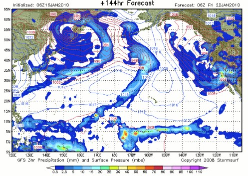
Satellite Models, 1/18/10 -1/24/10

I will continue posting today’s reports throughout the day, including rain totals, road conditions, wind reports, and current satellites in the Storm Watch for today below, but I also thought you might enjoy seeing the updated satellite models. These begin this morning at 10 am and continue through Saturday, one per each 24 hour period.


Monday


Tuesday


Wednesday


Thursday


Friday


Saturday

Storm Watch, 1/18/10

4:00 pm – the hail storm at 1 pm was short, but wicked, and then there has been no further news to report today. Looks like it is over until tomorrow morning (NEXRAD is still showing some sprinkles coming our way), when the next wave is expected to hit. That one is predicted to be of less severity, and involve less winds, but the one on Wednesday is predicted to be stronger than that received today.

1:00 pm – a nice two-hour break in the rain, and now it is hailing!

11:00 am – rain update: 1.9 in Big Sur Valley today; 3.35 up here. 3/4 inch just in the last hour!!

11:00 am – ROAD HAZARD: CAL-TRANS IN PROCESS OF CLEARING DEBRIS AT MM 31 (SANTA LUCIA RANCH.)

And I just heard a huge crash, scared both the dogs and I, and found that a pole, which had been dug into the ground, had fallen, blocking the door. Fortunately, I was able to kick at the bottom of the door enough to move the pole enough to open the door. Otherwise, it would have been to crawl out the emergency exit window. That would have been fun!!

10 am – 2.6 inches of rain so far today. Time to empty the rain gauge, as I did not do it last night! That makes 4.5 inches this week, and 31.1 inches for the season.

An excerpt from NOAA discussion for today: “DAY1 PROD HAS US IN A SLIGHT RISK FOR SEVERE TSTORMS WITH THE MAIN RISK BEING STRONG WINDS AND BRIEF TORNADOES.”

9:30 am – ROAD HAZARD – FLOODING ON HIGHWAY ONE JSO OF ANDREW MOLERA SP PER CHP

9:15 am – In a twist of irony, scanner traffic is reporting downed power lines near Garrappata have started a fire. Crews responding. Well, that one can’t be going anywhere, not with this rain!! CHP has it as two separate fires near Garrappata Creek Bridge.

I’ve been guessing winds gusting up to at least 75 mph, and the gauges at Highland/Big Creek confirm that is what is being recorded there. Confirmed with my neighbor, who has a wind gauge, it is gusting around 75 mph up here. Although, I am a bit more exposed than my neighbor, so my winds could be a bit stronger. Are we having fun, yet?

8:30 am – one inch of rain in the last 1 and 1/2 hours. Up to 1.6 so far today. Having internet problems, so no pics until that is resolved. Wind still HOWLING! At times, it sounds like a freight train rollin’ on through.

NWS Satellite shot:

7:30 am – ROAD HAZARD – CHP reports vehicle hit a rock 1/4 mile south of Gorda and is leaking gas. Tow truck ETA 90 mins.

7:15 am ROAD HAZARD – CHP reports a traffic collision at Sycamore Canyon and Highway One, no details. CHP and PG&E enroute. Cones out by RP. Source in Big Sur Valley says it is a PG&E truck that went up the bank and landed on its side.

7:00 am – The wind started around 1:30 am. I don’t know when the rain started. .6 inches so far this morning, 2.5 inches for the week, 29.1 inches for the season. Winds are gusting quite high currently, and tossing anything that isn’t tied down – even was blowing around my gennie, so had to move it. Current satellite pics when I can. Internet is not cooperating.

Storm Watch, 1/17/10

6;20 pm – CHP REPORTS A “TRAFFIC HAZARD IN THE NORTH BOUND LANE OF HIGHWAY ONE, JNO OF TREEBONES NEAR 71895 SR1… LARGE BOLDER NEAR MM 10.” GORDA IS AT 10.2, 10 IS SOUTH OF GORDA AND TREEBONES IS NORTH OF GORDA. CURRENT CHP INFO IS THIS IS NORTH OF WILLOW CREEK BRIDGE, which makes sense.

5:00 pm – it has been very quiet the last two hours. I received a total of 1.9 inches today, for a season total of 28.5 inches. Big Sur Valley reports 1 inch for today. Tomorrow’s storm is predicted to be stronger.

3:30 rain has stopped for the last 1/2 hour.

2:30 pm – current rain total for today, 1.75 inches and still climbing. Current radar map to follow when the internet allows:

1:30 pm – current rain total for today, 1.5 inches.

12:30 pm – up to one inch, so far.

Current (noon) radar

11:30 am – ROAD REPORTS – Traffic Accident near Radio Point around 10 am of solo vehicle on roof, in flames. CHP on the scene now at 11:30 am and rescue going on as I type. There is another accident JSO of Bixby of vehicle over the side 120 ft. from roadway. Two injured have been recovered as I type. Pole leaning into roadway JSO Big Sur at 10 am. HEAVY rain being reported south of Pt. Lobos. Obviously dangerous conditions, so if you must drive, drive VERY carefully! And this is the just the first, “mild” storm.

11:30 am – looks like 6/10ths now, or about a 1/10th an hour up here on my roost.

10:30 am – Contacts in Pebble Beach and Big Sur Valley state it is raining in both places, as it is here. No longer steady drizzle, but definite rain. NOW up to 1/2 inch!

9:30 am Current radar map

8:00 am – almost 1/2 an inch of rain last night/this morning –correction, received 4/10ths — and I have no idea when it started. No rain in San Jose. More reports as they are gathered or submitted. Three reports issued by NOAA:

One…HIGH WIND WATCH IN EFFECT FROM MONDAY MORNING THROUGH MONDAY EVENING FOR THE COAST AND COASTAL MOUNTAINS FROM SAN FRANCISCO SOUTH THROUGH MONTEREY COUNTY…

Two … THIS HAZARDOUS WEATHER OUTLOOK IS FOR SAN FRANCISCO BAY AREA AND MONTEREY BAY AREA.

.DAY ONE…SUNDAY AND SUNDAY NIGHT

AN APPROACHING STORM SYSTEM WILL BRING RAIN AND GUSTY WINDS TODAY AND TONIGHT.

.DAYS TWO THROUGH SEVEN…MONDAY THROUGH SATURDAY

A SERIES OF STORMS ARE EXPECTED TO IMPACT CALIFORNIA DURING THE WEEK. DUE TO MANY DAYS OF RAINFALL ACCUMULATION…HYDROLOGIC CONCERNS ARE POSSIBLE. IN ADDITION…THESE STORMS ARE FORECAST TO PRODUCE STRONG GUSTY WINDS BOTH OVER THE WATER AND LAND. DUE TO THE STRONG WINDS A HIGH WIND WATCH HAS BEEN ISSUED FOR MONDAY MORNING THROUGH MONDAY EVENING.

IN ADDITION…A LARGE WEST TO NORTHWEST SWELL WILL MOVE INTO COASTAL LOCATIONS STARTING LATE TUESDAY AND CONTINUE THROUGH WEDNESDAY. SEAS ARE FORECAST TO BUILD TO AROUND 25 FEET BY WEDNESDAY WITH EVEN HIGHER AMOUNTS POSSIBLE.

Three … MOST IMPORTANTLY…WEDNESDAY THROUGH FRIDAY IS WHEN FLASH FLOODING POTENTIAL ON MANY SMALLER STREAMS HAVE THE GREATEST CHANCE OF HAPPENING. BY THIS POINT THOUGH…THE MAIN STEM RIVERS SHOULD ALL STILL BE WELL WITHIN THEIR BANKS.

AFTER ANOTHER BRIEF BREAK TUESDAY NIGHT THE RAIN PICKS UP AGAIN ON WEDNESDAY WITH THE MOST SIGNIFICANT RAINFALL POTENTIAL OF THE WEEK. THE ASSOCIATED LARGER SCALE TROUGH IS FORECAST TO PERSIST OFF THE CALIFORNIA COAST UNTIL FRIDAY MORNING BEFORE STARTING TO HEAD
INLAND. THIS COULD MEAN SEVERAL WAVES OF MODERATE TO HEAVY RAIN DURING THAT TIME. RAINFALL TOTALS FOR WEDNESDAY THROUGH FRIDAY COULD EASILY REACH AN ADDITIONAL 3 TO 5 INCHES WITH THE WORST OF IT OVER THE COASTAL RANGES.

THIS HYDROLOGIC OUTLOOK IS INTENDED TO HIGHLIGHT A HAZARDOUS FLOOD SCENARIO THAT IS DEVELOPING. ALTHOUGH NOT COMPLETELY SURE OF THE LEVEL OF SEVERITY THIS WEEKS EVENTS WILL REACH…CONFIDENCE IS HIGH THAT IT WILL BE SIGNIFICANT AT A MINIMUM.

Satellite Models for upcoming week

Obviously, these are just computer models of what we can expect for the upcoming week, starting tonight at 10 pm. These allow us to see visually why NOAA is predicting as it is.


Tonight at 10 pm


Sunday at 10 am


Sunday at 10 pm


Monday at 10 am


Monday at 10 pm


Tuesday at 10 am


Tuesday at 10 pm


Wednesday at 10 am


Wednesday at 10 pm


Thursday at 10 am


Thursday at 10 pm


Friday at 10 am


Friday at 10 pm

>
Saturday at 10 am

Of course, these are only models, and Mother Nature does not always abide by our models.

Storm Watch, 1/16/10

6:30 am – beautifully clear sunrise. Checked all NOAA reports and little change. Everything is still on track as previously reported. Will continue to report as things roll in and if any additional information is discerned or sent my way. I’ll also try to get today’s satellite pics up later.

NOAA Hydrological Concerns

This is the current (as of 1/15/10 at 10 pm) hazardous outlook concerns regarding hydrology from NOAA:

AS THE FIRST AND WEAKEST SYSTEM MOVES THROUGH…ONLY LIGHTER RAIN IS EXPECTED FROM SATURDAY INTO THE MID MORNING HOURS ON SUNDAY WITHRAINFALL TOTALS LIKELY A HALF INCH OR LESS.

THE RAIN IS FORECAST TO INTENSIFY DURING THE DAY SUNDAY…INITIALLY ACROSS THE NORTH BAY AND THEN EXTEND SOUTHWARD. BY DAYBREAK ON MONDAY RAINFALL TOTALS ARE EXPECTED IN THE 1 TO 2 INCH RANGE WITH 3 INCHES A POSSIBILITY OVER THE COASTAL RANGES. THROUGH THIS TIME PERIOD THERE ARE NO CRITICAL HYDROLOGICAL CONCERNS OTHER THAN NUISANCE AND LOCALIZED FLOODING ON ROADWAYS AND LOW LYING AREAS. MANY SMALLER
STREAMS SHOULD START TO SHOW AN AMPLE RESPONSE TO THE RAINS BUT NO MAJOR FLOODING IS EXPECTED THROUGH MONDAY.

THE NEXT SYSTEM BRINGS HEAVY RAIN POTENTIAL ON MONDAY AND MONDAY EVENING WITH AN ADDITIONAL 1 TO 3 INCHES OF RAIN FORECAST. OF NOTE BY MONDAY NIGHT…FOR THE MOST PART SOILS SHOULD BE NEAR SATURATION AND ADDITIONAL RAIN COULD RESULT IN RAPID AND SUBSTANTIAL RISES ON
LOCAL STREAMS.

AFTER A BRIEF BREAK MONDAY NIGHT THE RAIN PICKS UP AGAIN ON TUESDAY THROUGH TUESDAY EVENING…THIS TIME A SLIGHTLY STRONGER SYSTEM. AN ADDITIONAL 1 TO 3 INCHES BY TUESDAY EVENING IS EXPECTED WITH 4 INCHES NOT OUT OF THE QUESTION.

MOST IMPORTANTLY…TUESDAY THROUGH FRIDAY IS WHEN HYDROLOGICAL CONCERNS BECOME THE MOST SERIOUS AND FLASH FLOODING ON MANY SMALLER STREAMS COULD BECOME A REALITY. BY THIS POINT THOUGH…THE MAIN STEM RIVERS SHOULD ALL STILL BE WELL WITHIN THEIR BANKS.

AFTER ANOTHER BRIEF BREAK TUESDAY NIGHT THE RAIN PICKS UP AGAIN ON WEDNESDAY WITH THE MOST SIGNIFICANT RAINFALL POTENTIAL STORM OF THE WEEK. THIS LARGER SCALE TROUGH IS FORECAST TO PERSIST OFF THE CALIFORNIA COAST UNTIL WELL INTO FRIDAY BEFORE HEADING INLAND. THIS COULD MEAN SEVERAL WAVES OF MODERATE TO HEAVY RAIN ACROSS CENTRAL CALIFORNIA DURING THAT TIME. RAINFALL TOTALS FOR WEDNESDAY THROUGH FRIDAY COULD EASILY REACH AN ADDITIONAL 3 TO 6 INCHES. THE WORST OF IT WOULD CONTINUE TO BE EXPECTED AROUND THE COASTAL RANGES.

THIS HYDROLOGIC OUTLOOK IS INTENDED TO UNDERSCORE A HAZARDOUS FLOOD SCENARIO THAT APPEARS TO BE DEVELOPING. ALTHOUGH NOT COMPLETELY CERTAIN AT THIS TIME WHAT LEVEL OF SEVERITY THIS WEEKS EVENTS WILL REACH…AT A MINIMUM CONFIDENCE IS HIGH THAT IT WILL BE SIGNIFICANT.

EVERYONE NEEDS TO SERIOUSLY PLAN FOR THEIR WEEK AHEAD. THIS IS THE STRONGEST STORM OF THE WINTER SO FAR AND IF YOU COMBINE THE RAIN POTENTIAL WITH THE VERY STRONG WINDS THAT MAY DEVELOP…CONDITIONS WOULD LIKELY BECOME SEVERE. PEOPLE LIVING NEAR RIVERS AND STREAMS OR
OTHER FLOOD PRONE AREAS SHOULD BE ALERT FOR THE POSSIBILITY OF FLOODING…PARTICULARLY OVER THE LAST HALF OF THE WEEK AHEAD. REMEMBER…IT TAKES AS LITTLE AS ONLY 1 FOOT OF MOVING WATER TO SWEEP AWAY A VEHICLE.