Tonight storm

20130330-211943.jpg

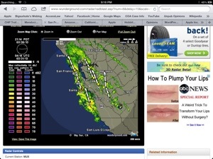
9:00 pm, Saturday night, 3/30, right on time … It is really raining – real rain! Not just a bit of a drizzle … Real, much needed, wonderful rain!

Current radar. Black boxes are lightning strikes.

This is what one forecaster predicts for tonight

20130330-044631.jpg

That’s Big Sur, right smack in the middle of the yellow.

Pitkin’s Bridge & Rain Rocks Shed

Here is a photo of the entire project by CalTrans resident Engineer, Charlie Hench

20130321-165711.jpg

Fascinating to one who has lived with this crazy combo of slides for 24 years. The slide at Pitkin’s Curve is dirt, and will go UNDER the bridge. The one at Rain Rocks is … Well, rocks. It will go on top and over the shed.

Storm Coming in.

8:00 pm – I LOVE the sound of the rain! We are so thirsty!,,

7:00 pm – I didn’t think much of this storm, so haven’t followed it closely, but the tell-tale winds tonight let me know it was coming, and then, letting the cats out at 7:00, the drizzle let me the front was just beginning to arrive. I’ll check my usual sources, and let you know what I find out. I know SLO, was predicting this morning that it wouldn’t go much south of Paso.

20130319-192550.jpg

New Photo Contest

My dear friend, Vilia Kakis Giles,Vilia Kakis Gilles, Realtor (one of my Ladies of the Sur friends) is sponsoring this new header photo contest. She has donated a $100 gift certificate to Local Color, a wonderful shop full of local art, jewelry, and clothing in the Village Shopping Center.

You can submit up to two photographs of Big Sur. remember, they must be attached to an email to me, at kwnovoa@mac.com, in jpg format, and be sized to fit the header, 760 x 151 pixels.
The deadline for submissions is midnight, 3/30. Out of all submissions, I will pick somewhere between 5-10 entries to post on my blog, and readers will pick the final winner. I would prefer a Spring or Summer theme, but all entries considered.

Rocky Creek Road Closures

** UPDATE #22 **
HIGHWAY 1/ROCKY CREEK VIADUCT PROJECT CONTINUES WITH DAYTIME ROADWORK AND INTERMITTENT OVERNIGHT CLOSURES

Daytime roadwork on Highway 1 continues next week from 7 am to 5 pm Monday, March 18 through Friday, March 22.

Overnight closures next week are as follows:
· Sunday, March 17 through Thursday, March 21—9 pm to 7am—full closure each night; details are as follows:
o Sunday, March 17 through Monday, 18 (7 am)—full closure will be the usual project limits;
o Monday, March 18 through Thursday, March 21 (Friday 7am)—EXTENDED full closure will begin just north of Rocky Point Restaurant to the usual project limits;
Bridge work being done on Sunday night is girder prep work. Monday through Thursday overnight work is girder installation. The 90-ft long girder delivery trucks need to back up to install girders—therefore necessitating the extended full closure from just north of Rocky Point Restaurant to the project limits.

NOTE: Residents will be allowed to get through the 2-mile section between Rocky Point Restaurant and the project limits during the overnight full closures from Monday through Thursday night (Friday am)

Highway 1 at Rocky Creek has one-way signalized traffic control 24/7. Traffic will be stopped for 10 minutes at a time during daytime roadwork. Full overnight closures will be scheduled five nights a week Sundays through Thursdays, unless otherwise indicated. No overnight closures will occur on Friday/ Saturday nights.

The project to construct a permanent viaduct about 15 miles south of Carmel near the Rocky Creek Bridge began on Sept. 4. Completion is scheduled by Labor Day, weather permitting. Daily roadwork schedules are subject to change due to weather conditions and other factors so stay tuned for regular updates.


Fire Clearance

It isn’t too early to put this on your to-do list. I actually started today. Two wonderful men who helped last year, are here again this weekend, helping to make my place safer for me, my critters, and the firefighters who will come, if needed.

This year, a burn permit is required, for getting rid of those burn piles, and I have a few. One can apply for this permit online, or stop by the station house to pick one up. Once that is done, one still needs to call to find out whether it is a permissive burn day, or not, and then notify the BSFVB of the burn, as well as your neighbors, so that everyone is aware.

Our lack of real rain so far this season has heightened the danger we all face. It has been 5 years since we had a significant fire. Make sure you are prepared. Have a plan in place to stay or flee. Have a plan for your critters and important papers, photos, etc. One plan, is to make sure your home is prepared to withstand whatever comes your way.

I’ll have more on this in the upcoming weeks, but for now … START PLANNING!

Snow on Cone Peak

There IS snow on Cone Peak this morning, but it doesn’t go down very far, I’m guessing 4-4500′. None here, although it is very cold. I’m busy trying to stay warm. Have a great one, everyone, we are in for warmer weather next week.

Continuing Storm Report & Rocky Creek Closures

Noon – from the 9 am forecaster a winter weather advisory for the Santa Lucia Mts and the Los Padres National Forest.

THE BEST CHANCE FOR SNOW WILL BE OVER THE SANTA LUCIAS AS BOTH THE
ECMWF AND GFS CONTINUE TO KEEP A BULK OF THE PRECIPITATION OFF
SHORE. A WINTER WEATHER ADVISORY IS IN EFFECT FOR THE SANTA LUCIA
MOUNTAINS AND LOS PADRES NATIONAL FOREST AS WELL AS THE MOUNTAINS
OF SAN BENITO COUNTY AND INTERIOR MONTEREY. THIS AREA WILL SEE THE
BEST INSTABILITY COMBINED WITH MOISTURE AND LIFT. THE LIMITING
FACTOR IS THAT WHEN THE BEST MOISTURE IS PRESENT THE WINDS WILL
ACTUALLY BE COMING FROM THE EAST…LIMITING THE OROGRAPHIC EFFECTS
SEEN WHEN MOIST WEST WINDS ARE PUSHING OVER THE MOUNTAINS. NON THE
LESS THESE CONDITIONS WILL SUPPORT THE WINTER WEATHER ADVISORY
WITH 5 TO 10 INCHES OF SNOW POSSIBLE ABOVE 3000 FEET AND 1 TO 4
INCHES AT ELEVATION OF 2500 TO 3000 FEET. THE WINTER WEATHER
ADVISORY IS IN EFFECT FROM 1000 AM THURSDAY TO 1000 AM FRIDAY.

8:00 am, From NOAA’s 3:30 am forecast discussion –

RAIN WILL RETURN TONIGHT INTO THURSDAY MORNING AS THE UPPER AIR LOW DIVES TO THE SOUTH TOWARD OUR AREA. SHOWERS WILL SPREAD ACROSS THE ENTIRE CWA WITH THE MAIN FOCUS ALONG THE COAST…IN PARTICULAR MOUNTAINS IN MONTEREY AND SAN BENITO COUNTIES. SNOW LEVELS WILL DROP DOWN TO AS LOW AS 2500 FEET WITH A GOOD POSSIBILITY OF SUBSTANTIAL SNOWFALL OVER 3000 FEET. A WINTER WEATHER ADVISORY IS IN EFFECT FOR THOSE AREAS.

They also mention the possibility of hail and lightning. Stay warm, everyone!

Also, Rocky Creek Road Closures:

Night closures next week are as follows:
· Sunday, March 10 through Thursday, March 14—9 pm to 11 pm with up to 10-minute delays;
· Sunday, March 10 through Thursday, March 14—11 pm to 7 am (Friday am) with up to 30-minute delays;
(Roadway will remain OPEN each night next week—no overnight hard closures)

Upcoming storm

20130305-203510.jpg

8:00 pm – From a friend, and former Big Surian, in very Northern California, near Arcata: “Heads up- The light storm they predicted up here has turned out to be pretty fiesty- Big winds and about 1/2 inch rain so far. Winds blew so hard that smoke came back down the chimney into the house.”

Per an earlier NOAA, this is heading our way, but quite peaceful at the moment. I’ll send out an alert to a friend in Petaluma, and maybe she can let us know when it hits there. Petaluma: “Wind has come up within the last half hour and light rain starting, very cold!”

20130305-201635.jpg

I put another log on the fire.

And there is the satellite photo from NOAA and Capt Lingcod.

Part of the forecast discussion from NOAA:

…BUT IF THE NAM AND EURO KEEP SHOWING HIGH QPF A WINTER
WEATHER ADV WILL BE NEED FOR THE HILLS OF MONTEREY/SAN BENITO
WEDNESDAY NIGHT INTO THURSDAY. IN ADDITION TO SNOW POTENTIAL…THE A
COLD CORE UPPER LOW WILL INCREASE CHANCES FOR SCATTERED
THUNDERSTORMS AND SMALL HAIL. DAY 3 OUTLOOK FROM SPC HAS ENTIRE
CWA IN GEN RISK FOR THUNDERSTORMS.

The soft, gentle rain …

… Started sometime after dark. Not the wild, whipping rains of winter, but the soft gentle rains of Spring, even though it is a just under 3 weeks away. We really need the moisture, too. The bigger storm is predicted for Weds. With snow down to 3000-3500′