Friday hearing for Cal Trans crew

I was in court yesterday for part of the hearing. Bail remains set at $1,000,000 each. Preliminary hearing remains set for Friday, May 18th at 10:00 in Judge Pamela Butler’s court room, although a challenge under Penal Code 170.6 seems likely to be filed by one of the five attorneys in the matter.

One evening anchor man from a local Monterey station was present, and asked to speak to Tom Worthington, Juliet Peck, or myself, but we were all too upset with the court’s refusal to consider anything the defense had to say about a bail reduction, to respond to the press.

Given the nature of these judicial proceedings, from the overbearing nature of the initial assault on the south coast, to allegations made by the DA in open court, to the court’s refusal to consider anything on behalf of the defendants, as a member of this community I feel stifled in what I can and cannot share on this or any other public forum. I just urge every one to keep an open mind until this case is concluded.

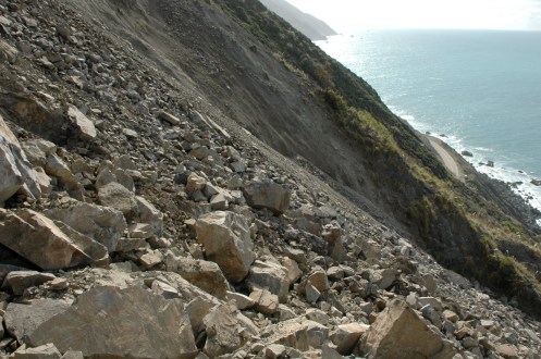
No Willow Springs Maintenance Crew means this section of the highway is no longer safe. Driving home from the North Coast today, Saturday, there was a minor slide south of Limekiln. There were quite a few rocks in the north bound lane, and a few in the south bound lane. There is no one for me to call or stop and see to let them know. This could a harbinger of things to come, not necessarily, but it could be a warning from Mother Nature.

Remember, there are many layers to most cases, this one in particular. Also, as an aside, Cal Trans is suing the estate of the dead bus driver and the tour company who employed him, for damage to a bridge out near Soledad, when the driver crashed into it, killing four French tourists, per a report in yesterday’s Pine Cone. Cal-Trans is suing for one million dollars. I have never heard of such a thing. Nice, huh?

Road Closure Update, 1/23/12

Noon – From Cal-Trans:

Cal-Trans official press release says there is no anticipated date of re-opening of the road.

9:30 am – semi-official report: there is no equipment buried under the slide, none of the rock shed is affected, the slide didn’t take out the light, only the wires going to the light, and it is expected that the road will be open in 3-4 days, but still waiting for the geologist’s analysis.

8:30 am – reported by local in comment section below: “Just went for a look, was told by the flagger that the slide has buried part of the rock shed, with much of their equipment, and will probably be closed for at least a couple of days. Also unofficial, but that was at 8:20 this morning.” If all that equipment is buried, it will be more than a couple days!

7:30 am – Per one of my “unofficial” but very reliable sources, the slide occurred just south of the new Rock Shed at Rain Rocks, and took out the light on the southern end of the construction. I have no word from Cal-Trans “official” sources, yet, about how long the closure will last. I suspect I will not get any official word until mid-day or later, as the resident geologist will have to evaluate the situation, then get the word to the PR guys/gals. Will update as soon as I have additional information. BTW, the CHP website no longer shows this closure, but that does not mean it is open.

Nepenthe Fire Photos 12/2/11

If all goes well, and it hasn’t so far, I have 4 or 5 photographs of yesterday’s fire sent in by readers, showing different points of view. Quite fascinating to see the fire from different perspectives. Okay, it has been a couple hours, unknown what the problem is, as I have 4 bars, but can’t surf the internet. I’ll get them up when I can.

First, here WILL BE two from Wally Barnick of Coast Outfitters, and one from Sander Koning, of Nepenthe, and one from Joshua Gallo Hernandez, of Ventana – WHEN this blasted internet gremlin moves somewhere else!

Nepenthe Fire by Wally Barnick (12/2/11)
Nepenthe Fire #2 by Wally Barnick (12/2/11)
Nepenthe Fire by Sander Koning (12/2/11)
Nepenthe Fire by Joshua Gallo Hernandez (12/2/11)

Upcoming Public Meetings

Sorry I haven’t been in cyberspace for a bit. End of summer approaches, and it is as if there is a frenetic energy for out of town visitors to beat the Labor Day crowds. My aunt and uncle come every year for a month to Pismo Beach, and it is my one time to visit, so I often go spend a few days down there. Out-of-state visitors are also coming for a visit in the next few days, and Rock Knocker has needed my help on some overnight projects lately, too. Of course, I squeeze some work in between all of this. Summer photos shortly.

Several Cal-Trans meetings are being held in the next two weeks that are of interest to all of us.

The first is regarding the design of the viaduct at Rocky Creek:
“HI Everyone,

We have scheduled our first Aesthetic Design Advisory Committee (ADAC) meeting to discuss the aesthetics of the proposed Rocky Creek Viaduct (bridge) railing, that will be constructed along the ocean side of the structure and will be designed to not only protect errant vehicles from the edge but also bicyclists and pedestrians.

The meeting will be held at the Big Sur Station Multi-Agency Facility on August 10, 2011 starting at 10:00 AM and lasting until approximately 1:00 PM or until we mutually agree we’ve covered the topics.

A packet of information will be emailed out to everyone prior to the meeting.

Thank you everyone for your participation!

Ken Dostalek
Caltrans, District 5
Project Management

805-549-3133
*************************************************************
The second addresses the truck climbing lane between Rio Rd. and Carmel Valley Road:

Fourth of July Weekend has begun

Yes, I know, it is only Tuesday. Yes, I know, we have a 3-day weekend coming up, but based on what I witnessed today, it looks as if the weekend began a bit early.

As of this evening, around 7 pm, Kirk Creek Campground is full. Plaskett was almost full, and I suspect it will be by tomorrow. Frankly, I did not notice the Big Sur State Park. I did not even think to look, it being so early in the week. The other thing I noticed both yesterday and today, is that the gates to Limekiln State Park were open. it will “officially” open on Friday, July 2nd, but I imagine it will be full by then. No camping on the beach, as the bridge is still out, but the campground and redwood trails are open.

Also, the idiots are on the highway. Sorry, but there is no other word for them. The shoulder/pull-out at Rocky Creek was full, so, this car, an obvious idiot, just stopped on the highway. Never mind that there were four cars behind it speeding along at 55 mph. Sudden stops in the middle of the road are just plain idiotic. No one would even THINK of doing that on the freeways, but here? Oh, I know, the view is breath taking. But think about taking that next breath through a tube, or with a respirator, or other medical contraption to keep you alive. Just think. Please. The life you save might be MINE!

I have it on good authority that local patrols in the LPNF, at least here on the South Coast, will be stepped up in anticipation of this crazy weekend. I cannot tell you how grateful I am. I, too, will be out and about, probably several times. With my camera. Do something stupid, and you, too, could end up on my blog – memorialized for an eternity in cyberspace.

Oh, and the other great news? The two fire “rings” I featured in my “How NOT to build a campfire” article, are gone! I love you guys, as much as my dogs! Okay, let’s be real. Almost as much!

But what is a post without a photo? Trouble is, I was too busy trying to get home before dark to unload a fully packed Jeep, while at the same time, trying not to run over any idiots. But my friend Martha Diehl sent me a lovely summer roadside bouquet to brighten my day, and I’m going to pass it on, even though she doesn’t know! (She can flog me later.) Photo coming, when internet allows.

There is a small city at Pitkin’s Curve

All the following photographs were taken by Rock Knocker on May 11, 2010. He promised me he would go every month or so, with his hard hat and vest, and take more so we can all follow this amazing engineering feat, which started construction November 30, 2009, and is predicted to take four years.

Few of us could ever hope to get shots like this, and even fewer would ever get permission to do so. Thanks, Rock Knocker!

And it looks like this:

Small City

It even has its own Motel 6:

Motel 6 - We'll leave the light on for ya

Not that I’d want to stay there, even with the view!

Here is the new city from a longer perspective:

The View from above

My internet has gone wonkers on me this evening, and I have quite a few more photographs to post. I will have to add them tomorrow, as I have reached my patience limit tonight.

The two work platforms (and no, it is not the start of the bridge construction, that will be a while coming) are depicted here:

North and South Work Platforms

Here is the south work platform:

South Work Platform

Here is the north work platform. Note the people for perspective. That is a 150 TON crane sitting on the platform!

North Work Platform

This post is a “work in progress.” I will be uploading more photos as the internet goddess allows.

South Platform, looking north
North Platform, looking South

This “box” is 50 feet by 50 feet. Inside you see a remotely operated excavator. It has the drill on, and the plan is to drill a number of 5 ft. square holes, to an unknown depth, which will then provide support columns to anchor the south end of the bridge. This 50×50 foot box will then be filed completely with 5 ft. of cement.

This is the head honcho on this project. Rock Knocker told me his name … but I failed to write it down.

Tomorrow, I will post some Cal-Trans photos of the slip out in 2000 which lead to this project. I am also searching for the rendering of the project, which I have seen, and participated in (along with the rock shed at Rain Rocks) as part of the Aesthetic and Design Committee.

Mud Creek Photos (South Coast, Big Sur)

Yesterday, Rock Knocker climbed Mud Creek (about a mile north of Alder Creek Slide) to make sure it wasn’t backing up. (Yes, he IS retired, and no, he does NOT have to do this, but he is a curious fellow.) Normally, these are not the type of photos I would post, as some people are not interested in this type of thing. But I thought some of you might like to see how slides can happen (it is not backing up, therefore no slide is imminent) and get a different perspective on the hills and rocks that come down ON the road! I’ve even included some photos of the road from a perspective most of us are not likely to ever see. Definitely a unique perspective! RK took 104 photos, I’ve narrowed them down considerably, but I still have quite a few I want to share, so will be adding to this throughout the evening. Thanks so much, Rock Knocker!

Climbing up Mud Creek, by Rock Knocker

That’s Highway One, down below.
WARNING – DO NOT TRY THIS YOURSELF. Rock Knocker is a professional rock climber, and has been to the Cal-Trans climbing school each year for over 20+ years. In fact, he has been invited back again, even though he is retired.
Across the rockfall of Mud Creek, by Rock Knocker

One can see a sliver of Highway One in the distance on the right.
Looking down the rock fall, by Rock Knocker

I am afraid of heights. Even looking at a photo like this makes me queasy. Good thing he doesn’t have video!
Even higher still, by Rock Knocker

I can’t even BEGIN to describe what looking at this one does to my stomach! This is the one time I am “almost” – not quite – glad to Pampas Grass holding the hillside in place!
A tree grows ... by Rock Knocker

Amazing to see on this barren slope, a tree tenaciously growing out of rock.
Roots in Rock, by Rock Knocker

The close-up
The Coastline, by Rock Knocker

If one looks closely, one can see the CT cone, and the sliver of road in front of it.
Highway One - a different perspective, by Rock Knocker

Right behind where that front ridge and the highway intersect is the Alder Creek Slide. One can also see the recently rebuilt seawall at Shale Point.
Going down? by Rock Knocker

There is his truck, parked on the side of the road. And that ends the photo story of the climb up Mud Creek.

It is down to 37.6 degrees at 5:30 pm – and I need to update the weather/road post for today, March 9. 2010.

Highway Vandenberg Fire

5:00 pm – local news is reporting:
“Highway 1 re-opened just before 5 pm. So far the fire has burned more than 300 acres…There are 25 buildings on-base that have been evacuated…All non essential military personnel have been asked to evacuate VAFB and stand by for orders. The cause of the fire is blamed on a blown transformer. There are no reports of any buildings being burned in the fire.”

4:00 pm – Earlier today, a fire broke out on Highway One, near the main gate of Vandenburg Air Force Base. Much of the base was evacuated and Highway One was closed. At 3:15 it was 150 acres. Lots of air attack and strike teams have been responding on this one today, and as of 4:00 pm, it is reported by air attack that the fire is 400 acres and 80% “lined.” “Lined” is NOT the same as contained. This is being reported by gacc.nifc.gov as of 4 pm today:

“Highway Incident CA-AFV-003253 Fire reported at 288 + acres 0% percent containment burning in grass and medium brush. Threats / Values at risk Lompoc Federal penitentiary, Air force Village West and a major electrical transmission line in the fires perimeter. There are reports that the power to Vandenberg Air force Base is out to a majority of the base proper with some sections of the base are on back up power or generators. A Request for a Type 2 CIIMT has been placed to the GACC. There are a number of VLATs (Very Large Air tankers) are assigned.”

The DC-10 is working this one, but I don’t know what other VLATs.

There is live streaming video on Fox 11 (link below) which I cannot vouch for, as it is difficult for me to get live video with my connection.

MyFox11

Big Sur Marathon in one week

Just a reminder, the 24th Annual Big Sur International Marathon is a week from today, Sunday, April 26th. Highway One between the Deli/Post Office and Rio Rd. will be closed for the race. There are only 2 caravans going south, starting from Rio Rd. at 8:45 am and again at 11:00 am. There are 3 heading north, starting at 7:20 am at the starting line; 9:50 am at Point Sur; and 11:55 am at Palo Colorado. You can download the entire caravan schedule here: 

http://www.bsim.org/site3.aspx

Storm Report & Road Closure

9:00 pm – conserving power for posting tomorrow, first light, and also conserving my own power, as I have been sick with a nasty grunge for DAYS!! Check back in the am, and I will post what I can find out.

6:45 pm – I have received another 1/4 inch in the last 45 minutes. It is POURING, some hail, too. Imagine being inside a tin can with someone shooting BBs at you. That is what it is like up here, at the moment.

6:00 pm – This is from various sources:

Highway 1 is closed in both directions because of a mud slide. The CHP website has the south end closure at MM 44 (Nepenthe), and the north closure at 46, I believe, and cars are being turned around in both directions. Per CHP, closure all night, crew to clear in am. Reports are that this mudslide is significant, and one can NOT get through, even locals. Updates, as available, and my battery power allows.

It is being reported that the mudslide is at the Big Sur River in the State Park, and that the mud  is near the top of the K-rails surrounding the Big Sur Lodge, and that same water has seeped into the Lodge itself. If my friends who live near-by send me any photos tomorrow, I will be sure and post them. 

Also, it is raining like crazy up here, and I received 3/4″ since 8 am. Season rain totals tomorrow.