Black & White Photography

While there are a number of fires in progress, none are close or in neighboring counties, and it is Tuesday in Big Sur, I decided to go back to my long-ago roots a few days ago.

Last week, while Gideon was a drop-off at the Vet’s, I found myself with a lot of time to wander. So, of course, I took photos. One of the things I discovered about my D-90, was that I could shoot in monochrome. One sees differently, when photographing in Black & White. It is the shapes, the light, the shadows, the textures that catches one’s eyes.

I was inspired to try it again, after viewing Kirsty’s photographs here.. She lives in Australia, and has an incredible talent. She put together a slide show of an abandoned factory, perfectly suited for the medium, and did such an awesome job, I decided to wander Morro Bay with a black and white eye. These are some of the things I discovered.

Shapes

Textures

Shapes & Textures

Shapes, Light, and Reflections

Its been a long time since I was in a “rough” bar – oh, wait a minute. I went to the DOG not long ago, but not rough anymore!

Highway 166 Fire

UPDATE – As of 7 am this morning, July 13th, KSBY is reporting the fire at 450 acres and 80% contained.

This afternoon, a wildfire broke out near Cuyama on Highwy 166 near Wasioja Rd. By 4:30 pm this afternoon, it had scorched around 100 acres and it is estimated to be approximately 50% contained. While some structures, mostly outbuildings and ranch homes, are threatened, no evacuations have yet been ordered. Santa Barbara County, San Luis Obispo County, CAL FIRE, and LPNF have all sent resources to the fire.

This photo is from KSBY in San Luis Obispo.

Highway 166 Fire, KSBY news photo

Here is a great link for scanner for SB fire covering the Highway 166 fire, although law enforcement is also mixed in: 166 fire scanner

There is a slight smoky inversion layer in front of Cone Peak that I can see from my desk. It cannot be coming from the Highway 166 fire, and I am unaware of anything else that could be contributing to the layer, other than if it is left-over smoke from the Los Bueyes Fire four days ago.

Lightning Strikes in East SLO Co.

5:30 pm – so many small fires – wildfires, illegal campfires or backyard burns, vehicle fires – on LPNF today, impossible to keep up. Anything gets beyond the small category, and I’ll follow up for you.

3:00 pm – just found a great fire predictive services podcast for Central and South California for today and next week. You can view it here: fire predictive podcast

11:00 am – IHC teams from Arroyo Grande being sent to the Chester Fire, which LPF WildCAD gives a start time of around 7:30 am. No info on the Navajo Fire. Storm moving over California Valley and into the Southern Sierras, with possible rain and lightning. One lightning strike hit in Southern Monterey County about 8 am, per NOAA.

Around 4:30 am, a series of lightning strikes were recorded in eastern SLO Co.

LPF WildCAD is reporting a fire SE of La Panza named “Chester.” WLF is reporting two fires, the other Navajo. Both are reportedly small, but with difficult access and no road access. I cannot see any smoke at this time, but do see lots of high clouds SE of me.

Summer Fog

There is something refreshing and alluring about the summer fog on the coast. Living up here above it, I get scorching temperatures, and look down on the fog below. Sometimes envious, but mostly grateful I don’t live in it.

Fog over Willow Creek

I had to pass into it several times this week, and was surprised about how thick it was. For me, the fog presents another photo opportunity. I love what the fog does to the forest.
Foggy Forest

Trees in the Mist

Trees: Living Sculpture

Timeless Beauty

Tunnel of Light

Hartman Fire

There WAS a fire above Ripplewood last night. About an acre and 1/2. Still under investigation. It is called the Hartman fire, after the owner, but it was earlier misidentified as the Ripple Fire on WLF. Initial indications are it might have been an illegal campfire.

So, yesterday was a busy day – the Los Bueyes started around 2:15; the Gorda Fire (south of Gorda) around 3 pm, and the Hartman around 5 pm. All picked up quickly, the Los Bueyes lasting the longest.

Controlled burn on Ft. H-L escapes

11:00 pm – per WLF: “This was a control burn that escaped. There was a S/T 9340C from SLU training when it occured.

As of 2030hrs, fire was reported at 50 Acres and 40% contained.

Correct spelling for this incident is Los Bueyes.”

9:30 pm – as of this time, these are the resources assigned to this fire: LPF resources Assigned to this fire are
Divs-1
BC-11, 12
Eng: 16, 19, 31, 35, 37
Crew 3 Arroyo Grande IHC, 4 Los Padres IHC
Heli-527, 528, 530
WT-3
PT-19, 38

These are LPF resources only. Not Ft. H-L or Cal-Fire, which are both also on scene. What this tells me, and this is just intelligent guess work on my part, is that this fire is in or moving toward the LPNF. Based on the smoke drift shot I posted earlier, I would venture to speculate that the fire is moving in a westwardly direction. This one is going to bear watching over the next few days.

7:45 pm – Boillos Fire smoke drift from my front door. This is shot facing south, and Ft. Hunter-Liggett is to the left, or east in this photo.

6:45 pm – took a quick trip out back to South Coast Ridge Rd. and in the short amount of time I was gone, the visible smoke from my place markedly increased. The photo I am posting was before the increase in smoke. BTW, all of that grey dark stuff is smoke. It is clear blue skies in all the other directions.

5:30 – two more helios assigned, bring it up to 4 AA and 4 Hs.

4:45 pm – two more AA sent. This is the approximate location on base:

And here is a zoomed out version. The blue push pin is my location, about 6 miles due west of the fire.

3:45 pm – Controlled burn on Ft. Hunter-Liggett started at 10 am this morning appears to have escaped around 2:15 pm, per LPF WildCAD. I have been hearing and seeing planes overhead about an hour or two ago, about the time that LPF WildCAD reports the incident as Los Boillos Wildfire. Trying to get more information as to size and direction. I can see a lot of smoke from here, but no column. I may have to go out back to look. wildlandfire is reporting: “Aircraft in route from Paso.
75 acres in heavy brush.
Eratic fire behavior”

There are two AA tankers on scene and a helo. Neither LPNF office in King City nor the Ft. H-L PIO know anything at this time. Ft. H-L PIO is investigating and getting back to me with direction and ROS.

PIO for Ft. H-L called back and informed me it is still quite a ways away from me, but had no size or ROS or direction of spread to share. It is in training area 19.

So far, this year, these fires are being attacked early and agressively, and it may be out before I go to bed. Hoping, anyway.

I just investigated a wildfire a couple miles south of Gorda, but that one has been controlled.

Just because …

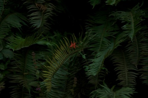
This is just one aspect of the magic that is Big Sur. This lonely little columbine is one of the few remaining.

When I saw this, I had to stop and capture it. The dark, the contrast between the one bright spot and the shadowy green called me. I shot it dark in the camera, and unlike most shots, I only took one, and was happy with what I saw in the LCD. I was even happier when I saw it larger on my computer. This is straight out of the camera, exactly what I witnessed. Mother Nature’s gift. And interestingly, I violated all the cannons of composition by placing the subject dead center, and still, it works.

Columbine & Ferns

Just because … Mother Nature’s beauty cannot be enhanced.
*********************************************************************
On a completely different note, Gideon has been sick since Saturday, and was at the vet’s Tuesday, and again today, when he was admitted to the hospital. News tonight is that he is improving. His fever is going down, and his pain has been lessened by an inflammatory drug. We are hoping he will come home Friday. Dr. will call again tomorrow morning. I am a tad distracted from my blog, but had this one prepared to go up. I’ll be back when Gideon is home again.

Limekiln State Park

As I indicated earlier, Limekiln State Park officially opened in time for the July 4th weekend. Dan Danbom, a photographer who has been featured on this blog in the past, and who tied with Ken Harlan for this quarter’s header photograph, came down the coast last week to enjoy his prize. Ken Harlan provides lunch for two at Lucia Lodge, or an SD card to the quarterly winner. (I can’t thank you enough for your generosity, Ken!)

Since Dan rarely gets this far South, he used the opportunity to check out Limekiln State Park, and sent me a report and some photos for your enjoyment.

Limekiln State Park 1 by Dan Danbom

From Dan: ” We also had wanted to see first hand the major construction of the highway, and also see how Limekiln had fared after the fire. When we drove by not long after the fire, it looked like it would be terrible, and it was closed. We usually do not have time to get that far south often.
Limekiln is different, but as we started up through the campground you could see the fire effects around, but a lot of the sorrel had come back nicely. Really we were very surprised how much the same it looked. We took our time up the Hare trail, and there were some big changes, and we could see where a lot of effort was put in to make the trail over, and improved. There are a lot of scarred and charred tree trunks and some left over fallen trees, branches that you could see would be hard to dispose of manually. But it really is still very pretty and a lot of the same character is still there.
It was a sunny day, and really contrasty, so not optimum for photos. (That is the one time I really wish for high thin clouds or some fog overcast, to give that open almost shadowless light for the forest.) But, I found a few selected vignettes of the creek, that still are pretty gorgeous in the shadows. And I think the redwood sorrel seems better than ever and really lush. So, it was a fun time taking some photos and enjoying a gorgeous piece of the coast. If you can stand a couple of more photos from me, I am attaching a couple of Limekiln for your review.”
Limekiln State Park 2 by Dan Danbom

Limekiln State Park 3, by Dan Danbom

Thanks Dan for the report, and the photos!

And as to his lunch at Lucia Lodge? This is what Dan had to say: “We read your comment that Limekiln was open or sort of, so since my schedule had changed unexpectedly, we decided to try to get an early start south, and take advantage of my Lunch (for Two) certificate for winning your header contest. Avis, mailed me a cert for lunch for two, at Lucia Lodge. So, despite the slow traffic at times, and the road stops, which really were not bad at all, we made it there for lunch. Very nice! It was a little hazy as the coast can be, but the view was stunning. We sat along the view table rail looking down the coast. Lovely lunch, be sure to thank Ken, (I will send Avis an email thanks too.) What a nice treat!”