
In honor of the death of a dozer operator, I am only posting this one photo today. More tomorrow. Let’s all be sending healing light, love, and compassion to his family and friends.
Photo by Michael Troutman:


In honor of the death of a dozer operator, I am only posting this one photo today. More tomorrow. Let’s all be sending healing light, love, and compassion to his family and friends.
Photo by Michael Troutman:
8:00 pm – tonight’s facts sheet (ED NOTE: Lots of changes)

3:00 pm from USFS:
Tim Bills commented on Soberanes Fire, Day 6, 7/27/16 – Expanded Evacuation Orders
Clare Long, Public Information Officer for the US Forest Service, will be available to the public at the Big Sur Station (Multi-Agency Facility) from 11 a.m. to 2 p.m. on Thursday, July 28 and Friday, July 29.
She will provide updates and information on the Soberanes Fire. We will also have large scale maps displayed at the station of the impact of the fire and operations to contain it.
Noon – 
8:20 am-
“I am saddened to report the death of a private dozer operator overnight on the Soberanes fire.
Details will be made available as next of kin are notified and as the Serious Accident Review Process is completed.
Please keep your situational awareness sharp as we head into what is shaping up to be yet another significantly challenging year for wildfires.
Chief Ken Pimlott
CAL FIRE Director”
Note the extended containment date? Over a month. No official word yet re dozer operator.

2:50, also by Eduardo. That is Pico Blanco on the left peaking up:

2:30 – Current photo from Clear Ridge by Eduardo Eizner

1:30 pm – I just completed my second interview of the day, this one with San Jose Mercury News. I used the opportunity to explain the terrain, the difficulty fighting fires here, and how most fires are started by illegal campfires, as we expect this one was, and also regarding the traffic problems due to people coming down to look and interfering with firefighters and residents trying to evacuated. I will use all of these opportunities to educate our city brethren.
12:00 noon – Just got word from Joe Bennett, the Condor biologist that our condor chicks are out of harm’s way, for now. They are keeping a close eye on the situtation.
KION just reported the death of a dozer operator on the Soberanes Fire. Sigh. It was a news flash, so I have no details.
IR interpretive data from last night’s flight, interpreted size 22,156 acres, growth 2,845 acres

IR Topo Map

7:28 am – oh, dear … Another large plume going up.
Today’s IR maps from John Chesnut. Blue lines indicate Tuesday’s perimeter.
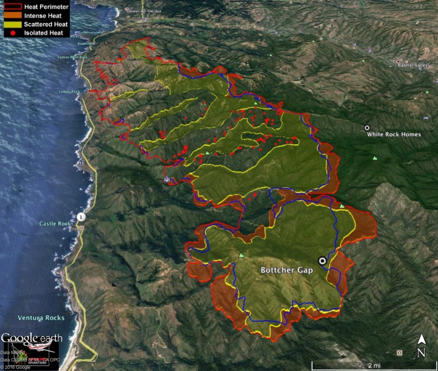

Today, I am giving these maps their own post. And this time, there is a map index so one can get the overall picture.


INFO IN RED CRITICAL PLEASE SHARE:


For those who are unclear about where this is, Lucas Ryan, who has been of immense help, put this together for me:
7:30 pm – Evening Facts Sheet;

6:30 pm -Acting Governor declares a state of Emergency for LA and Monterey Counties.
1:52 pm – From Fifth District, County of Monterey
SoberanesFire? declared number one fire priority in the nation by Cal Fire, BLM and USFS. All resources that are necessary are being granted.
1:30 pm – Public Information Map

NOON – they can hear me screaming in the next ridge – YAY!!!
Soberanes Fire – Day 5: The US Forest Service has issued an Emergency Closure Order for the Monterey Ranger District. Being on any trail or road in the closure area is prohibited. In a nutshell, this is the area of the Monterey Ranger District north of (and including) the Pine Ridge Trail.

11:o0 am – Monterey County Board of Supervisors just unanimously approved the Soberanes Fire state of emergency resolution following comments from Cal Fire, OES and Supervisor Potter.
While the resolution was drafted and in place the second day of the fire, the Board adopting it paves the way for the County to ask for a state of emergency declaration from the Governor’s office and to request state and federal financial assistance.
#SoberanesFire
7:30 am – Facts Sheet:

7:00 am briefing
#SoberanesFire has grown to 19,311 acres, 10% containment and 2,305 fire personnel helping fight this fire. Map similar, but main fire and spot now joined.

8:45 pm – recent MODIS map prepared by Adam Clark. Of concern is the southern block of red which is just about up to the Little Sur River.

8:30 pm – really?? I haven’t added anything since noon? I guess FB and official notices kept me busy. In any event, here are 4 photos taken at CV Airport by Lucas Ryan between 7:30 and 8:3o pm.
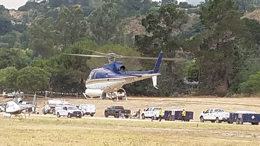


Noon: Currently four bombers are working Pico as well as the DC-10
BTW, as someone reminded me, did you remember to take your vitamins? I hadn’t and couldn’t remember when I did. I am also hydrating with iced tea right now, and Rock Knocker just asked me if I had eaten (I hadn’t) so he is making me a sandwich from groceries he picked up for me yesterday.
Some photos from Mescal Ridge last night provided but not taken byMichael Troutman


11:00 from the Deli RIGHT NOW

10:30 am – from Brendon Shave. The local is self-explanatory for locals, and even most regular visitors. Current conditions

8:30 am – Fire Line Plans for today from Highlands to Grimes Canyon – amazing information. I know they have over 50 dozers, but can they really do all this today??? Be ready, 12 different detailed maps I will hopefully get up in order.


topo map sent by John Chesnut

Also a couple of MODIS maps, also sent by John Chesnut (blue line is Sunday’s border)


7:30 am- a sweet little video sent to me by John Galt that is a wonderful way to start the daymand a great little reminder. Only 2 minutes. “I will be a hummingbird” Do yourself a favor, take two minutes out of an otherwise hectic day and watch it. Thanks, John;
7:00 am – Dawn Photos from Clear Ridge provided by Jen Smith


Left is south, right is north
4:30 am – it is getting harder to get any sleep during this emotionally trying event, but this sleeplessness is offering me the opportunity to explore other sources of information, and so I went to one of my favorite blogs for great info, maps, and photos, my friend, Keith Vandervere’s Xasauan Today site. His entry for yesterday, up through 10 pm, is full of useful data and insights. You can find him here: Xasauan Today. No one knows the backcountry like XT. You’ll want to bookmark this one.
Michael Selig posted some photos on a FB album taken at Green Ridge yesterday, 7/25, where he says his house is the only wooden one still standing. Try this link:
As usual, I will be updating these reports throughout the day, posting another simultaneously run Official Reports and Maps blog post, as well as a photography one.
Lots to do before sunrise comes. See you throughout the day.
This amazing photo taken at 4:30 this afternoon by Mark Readdie who JUST got home He explains it for us under the photo. This is probably my favorite shot of the day, but absent a catastrophe, my last post today. I am more tired than I’ve been since the Chalk Fire of 2008, and then I didn’t have to do FB or Twitter.

Kate,
Here are some observations.
Panorama photo from Mescal Ridge, downhill of Bonifacio Hill. On the right are Pico Blanco and Bixby Mountain. On the left looking out to Long Ridge, Green Ridge, etc.
Bixby Mountain and Mill Creek Preserve have burned and fire is in Bear Trap Canyon. The spot fire is down to the Little Sur River west of Pico Blanco. Three Calfire dozers are on Mescal Ridge above the Moon’s. I saw a number (6?) dozer transports parked at Andrew Molera. Their flagging was on a gate just south of the Old Coast Road.
Helicopters were dipping in the Moon’s pond this afternoon trying to save houses between Rocky Creek and Garrapata. Wildland crew and dozer structure protection activity in that area was observed with binoculars.
Dozers have opened the line along Long Ridge. Word is that they have gone along Skinner Ridge too. LPNF scout showed up this afternoon. Let’s see what they can do around Pico Blanco.
Mark
A message from Kate Healy around 9:30 was that her three kids had called and were up the with Warren (who contacted my at 6:34 am Sunday to report the Bixby Spot which I called in to 911) are up there with some regular firefighters taking on the fire as I post this.

Photo; Linda Kleisner. Delta Camp crews 1 and 3.

Photo Keith Vandevere, Firefighter burning off the fire line near Mal Paso, today.

Photo; Amanecer Eizner — Taken from “the top of Clear Ridge. Looks like it’s approaching Pico Blanco and Apple Pie Ridge” Taken today.

Photo From Barbara Sparhawk, View From Carmel Valley

Photo By Lisa Kleissner ‘View to Doud Drainage from beach’

Photo From Barbara Sparhawk – Carmel Valley
4:15 – a new Evacuation order has been issued for a portion of the Highlands, details here:
Also have heard from two different sources, but not any “official” ones that Red Wolf RD. Across from Pt. Lobos is also being evacuated. Highway is a mess, I am told.
FYI, Riley Ranch RD is on the east, but somewhat north of Pt. Lobos, for those unfamiliar.
