Fire Restrictions Elevated Today, 8/23/16

NEWS RELEASE

Los Padres National Forest
For Immediate Release
Contact: Andrew Madsen (805) 961-5759
Twitter: @LosPadresNF
Website: http://www.fs.usda.gov/lpnf

Los Padres National Forest Elevates Fire Restrictions

GOLETA, CA, August 23, 2016…Due to ongoing wildfires, extremely dry vegetation and very high fire danger, the Los Padres National Forest officials today announced Level IV fire restrictions will go into effect beginning today, August 23, 2016. The following restrictions will be rigorously enforced until the end of the declared fire season:
· Wood and charcoal fires are prohibited in all areas of Los Padres National Forest including designated Campfire Use sites; however persons with a valid California Campfire Permit are allowed to use portable stoves and lanterns using gas, jellied petroleum or pressurized liquid fuel within the designated Campfire Use Sites only. California Campfire Permits are available for free download from the Los Padres National Forest website (http://www.fs.usda.gov/lpnf ). You must clear all flammable material for a distance of five feet in all directions from your camp stove, have a shovel available, and ensure that a responsible person attends the stove at all times when it is in use.

· Recreational target shooting is prohibited in all areas of the National Forest unless specifically authorized by a special use permit with the Forest; however, hunting with a valid State of California hunting license during open hunting season is exempt from this restriction.

· Smoking is prohibited in all areas of the national forest except within an enclosed vehicle, building, or designated Campfire Use Site.

· Fireworks are prohibited at all times and in all locations within Los Padres National Forest.
· Operating or using any internal or external combustion engine without a spark arresting device properly installed, maintained and in effective working order on roads and trails specifically designated for such use. (This restriction is in effect year-round.)

Violators are subject to a $5,000 fine and/or six months in jail, and could be liable for the full cost of any fire suppression activities that result from their actions. For further information regarding current conditions as well as safety tips, contact your nearest Forest Service office or visit the Los Padres National Forest website at http://www.fs.usda.gov/lpnf.
###

Designated Campfire Use sites are ONLY at Kirk Creek Campground, Plaskett Creek Campground, and Nacimiento and Ponderosa Campgrounds within the LPNF.

Chimney Fire, 8/23/15

7:30 pm – Facts sheet:

image

4:00 pm – Paso Robles Fairgrounds, photo by Joanne Latham Bklacford:

image

3:00 pm – According to one of my more reliable sources, this fire has entered the SE corner of FHL near Waterdog Creek. That is just above the finger of fire on the west just crossing into Monterey County.

image

If you want to do this yourself for a different part of the fire, go to the list of links to the right under 2016 Fire Season, then Current Wildland Fire Maps and click on that. You will have to search for the area you want, so, for example, if you are looking for Copperhead Road, search for the nearest area, such as Bryson Hesperia, CA.

1:45 pm – for those who have not seen this, here is a video taken by the Park Rangers Association of a boat navigating Nacimiento Lake with flames all around. It is short.

Video taken in boat on Lake Nacimiento

Here is an interesting map that will show you where this fire is in relation to most areas:

image

Incident Update
Date: 8/23/2016 Time: 6:00AM
Fire Information Line: 805-543-2444

STATUS
Incident Start Date: 8/13/2016 Incident Start Time: 4:03 PM
Incident Type: Vegetation Fire Cause: Under Investigation
Incident Location: Chimney Rock Rd. & Running Deer Rd., South of Nacimiento Reservoir

Acreage: 37,101 acres Containment: 35%
Expected Containment: 08/29/2016 Injuries: 1
Structures Threatened: 1,896
Structures Destroyed: Residences 36 Other 16
Structures Damaged: 7

RESOURCES
Engines: 326 Water Tenders: 62 Helicopters: 17 Air Tankers: 7 Hand Crews: 107
Dozers: 46 Other: 3 Total Personnel: 3,983
Cooperating Agencies: California Highway Patrol, California State Parks, San Luis Obispo County Sheriff, Red Cross, California
Department of Corrections and Rehabilitation, California Conservation Corps, PG&E, San Luis Obispo Air Quality Board, San Luis Obispo Public Works, Paso Robles Fire Department, Monterey Co. Water Resource Board, California Department of Fish and Wildlife, US Army Camp Roberts, CAL-OES, San Luis Obispo OES, Monterey County Sheriff, Monterey County OES and USFS.

SITUATION
Overnight, fire behavior remained extreme. The fire continued to burn in steep terrain, along with very dry brush and timber. Once the morning inversion dissipates, winds will increase out of the south to southwest at 10MPH with gusts  around 20MPH. Temperatures and relative humidity will become wide spread, with temperatures in the 70’s on the western perimeter, to readings in the 90’s east of Rocky Butte Truck Trail. Upper level winds will turn out of north to northwest today, which will allow for the smoke aloft to drift towards the south-southeast of the Chimney Fire. Threats remain to Oak Shores, Christmas Cove, South Shore Village, Rancho Del Lago, Cal Shasta, Bryson Hesperia and Lake San Antonio. As with all evacuation orders and warnings, these are implemented for the safety of the public and firefighters. Please adhere to all orders, warnings, road closures and detours. Fire personnel are working in extreme fire conditions around the clock to contain and control the fire. Please do you part to be prepared to evacuate by visiting http://www.readyforwildfire.org .
Evacuations:
Ordered: Evacuation orders are in place for Christmas Cove, Oak Shores, North Shore Boat and Ski, Laguna Vista, South Shore Village, Rancho Del Lago, Cal Shasta, Lake San Antonio, Sapaqua Valley, and Bryson Hesperia in both San Luis Obispo and Monterey Counties. Any residents that have yet to evacuate are asked to do so immediately due to increasing fire activity in your immediate area.

Evacuation Centers:
Flamson Middle School
2405 Spring Street
Paso Robles, CA 93446
Small Animals – Chimney Fire Animal Shelter can be contacted at (805)423-4934
Large Animals – Horse Emergency Evacuation Team (HEET) 805-466-7457
Large and Small Animals – Chimney Fire Animal Relief (805)423-4934
Road Closures: G14 Interlake Road from Lake Nacimiento Dam to Bryson Hesperia Road. Traffic control points are being manned by CHP at Interlake Road at Bryson Hesperia Road, as well as Interlake Road at Lake Nacimiento.
http://www.readyforwildfire.org

7:15 am – John Chesnut’s Map (the green line across is the MoCo/SLOCo line):

image

7:00 am – Here is the IR map for today to get us started. I need to go start my coffee (TMI, right?) and then I’ll be back Intel gathering. CAL FIRE reported Tuesday morning that the Chimney Fire grew nearly 4,000 acres overnight to 37,101 acres burned. Containment of the blaze remains at 35%. Here is the link to the IR Topo map:

Topo IR PDF Map Link

image

Soberanes Fire, Day 33, 8/23/15

1:30 pm – Firing Operation resumes today, still in Cold Springs area. Photo by Jeffrey Carmichael.

image

8:00 am –

Soberanes Fire
Los Padres National Forest Service
August 23, 2016

DAILY UPDATE

Fire Information Phone (831)204-0446
Media Line: (831)484-9647
Email: soberanesfire2016@gmail.com
http://inciweb.nwcg.gov/incident/4888/
http://www.fire.ca.gov/current_incidents/incidentdetails/Index/1348

Incident: The Soberanes Fire was started by an Illegal campfire on the morning of July 22, 2016, in the Garrapta State Park. The fire is burning in areas of previous large fires including the Basin Complex in 2008 and the Marble-Cone Fire in 1977.
Location: Los Padres National Forest, Ventana Wilderness, Monterey County, CA
Agency Jurisdiction: CAL FIRE San Benito-Monterey Unit/Los Padres National Forest

Current Size: 87,316 acres (50,122 CA-LPF, 37,194 CAL FIRE,) Containment: 60% Cause: Illegal campfire
Injuries: 1 fatality, 4 injuries Structures Destroyed: 57 homes, 11 outbuildings Structures Threatened: 410
Current Resources: Crews: 32 Engines: 60 Helicopters: 12 Dozers: 27 Water Tenders: 45
Total Personnel: 1,988

Community Meeting: A community meeting will be held at the Cachagua General Store, located at 18840 Cachagua Road, Carmel Valley, CA on Thursday, August 25, 2016 at 6:00 P.M.

Current Situation: The fire continues to slowly move south and east of Miller Mountain in Hiding Camp Canyon, and farther south near the Ventana Cones. Fire behavior remains a slow backing and flanking fire through an eight year old fuel bed of grass, brush and timber litter. Near the coast range, the fire continues to flank southward in the Big Sur drainage below Mount Olmstead. Aircraft was utilized yesterday to cool and slow the southward progression of the fire. At present, there is no threat to the completed indirect containment lines along Tassajara Road to the east nor along Coast Ridge Road to the west.

Firing operations have not occurred for several days. The fire’s slow progress southward around Logwood Ridge is allowing firefighters to delay their tactical firing operations. These firing operations allow firefighters safer conditions while creating containment lines east of Coast Ridge Road. Firing operations are only conducted when weather and conditions allow for safe and effective operations. Firefighters continue to widen and improve indirect containment lines east from Anderson peak to Santa Lucia Memorial Park and northward to Arroyo Seco. These indirect lines are built on the ridges that stopped the Basin Complex of 2008.

California Interagency Incident Management Team Three, CAL FIRE and cooperators wish to thank the California National Guard for their contributions and support of the team efforts on the Soberanes Fire.

Wilderness Tactics: To reduce the impacts associated with fire suppression activities in wilderness areas, fire managers and firefighting crews continue using Minimum Impact Suppression Tactics as much as possible. The steep, rugged terrain of the Ventana Wilderness is inherently treacherous to firefighters. Most direct fireline is being constructed near the perimeter in areas that have been pretreated and supported by aircraft. The inaccessibility into the Ventana Wilderness along much of the fire’s east side continually requires patience, and slow and steady hard work from the crews, as they look for options to construct direct line.

The fire was caused by an illegal, unattended campfire on the Soberanes Canyon trail in the Garrapata State Park. Anyone with information is asked to call the CAL FIRE Tip Line at: (800) 468-4408. Fire managers want to remind the public that human caused fires are preventable. Please be aware of current fire restrictions and be careful with anything that could spark a fire.

US Forest Service Road and Trail Closures: A forest closure order has been implemented to close the trails and roads within the Los Padres National Forest, Monterey Ranger District pursuant to USC 551 and 36 CFR 261.50(a). The order prohibits going into or being upon National Forest System lands within the Soberanes Fire area. For a complete list of closures please visit: http://www.fs.usda.gov/lpnf . The following sites are open: Pfeiffer Beach Day Use, Mill Creek Day Use, Willow Creek Day Use, Sand Dollar Day Use, Kirk Creek Campground, Nacimiento Campground, Ponderosa Campground and Plaskett Creek Campground.

California State Park Closures: All California State Parks from Garrapata State Park through Julia Pfeiffer Burns State Park are closed until further notice; this includes Point Sur State Historic Park (Lighthouse), Andrew Molera State Park, Pfeiffer Big Sur State Park Campground and Day Use.

Evacuation Orders: An evacuation ORDER remains in effect for Coast Ridge Rd. from mile marker 1.5 to Marble Peak at the end of the road.

Evacuation Warnings: A WARNING remains for Tassajara Road from Carmel Valley Road to the Tassajara Hot Springs Zen Center. This area includes all roads that lead from the above described roads.

Donations: Local relief efforts to the fire victims have been provided by the Coast Property Owners Association (CPOA) and the Community Foundation for Monterey County. Donations can be made to the CPOA at Coast Property Owners Association, PO Box 59, Big Sur, CA 93920 or the Community Foundation for Monterey County, 2354 Garden Road, Monterey, CA 93940 (831)375-9712.

The Red Cross prepares for, responds to, and helps people recover from disasters big and small. To donate, people can visit redcross.org/donate/, call 800-RED CROSS (800-733-2767), or text REDCROSS to 90999 to make a $10 donation. For any unmet disaster related needs, please call their 24 hour hotline at 1.866.272.2237.

Additional Cooperating and Assisting Organizations: California State Parks and Recreation, California Highway Patrol California Office of Emergency Services , California Department of Corrections & Rehabilitation, California National Guard, Big Sur Land Trust, California Department of Transportation, California National Guard, California Fish & Wildlife, Coast Property Owners Association (CPOA), Community Foundation for Monterey County, Bureau of Land Management, American Red Cross, County of Monterey, Pacific Gas and Electric, Carmel Highlands F.P.D., Monterey County Regional Fire Protection District, Mid Coast Volunteer Fire Brigade, Big Sur Volunteer Fire Brigade and the Cachagua Fire Protection District.
This electronic message contains information generated by the USDA solely for the intended recipients. Any unauthorized interception of this message or the use or disclosure of the information it contains may violate the law and subject the violator to civil or criminal penalties. If you believe you have received this message in error, please notify the sender and delete the email immediately.

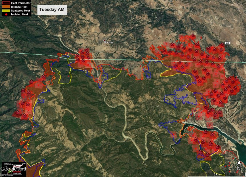
7:15 am – John Chesnut’s Map:

image

7:00 am – Here is a aborted water drop last night near Lower Stone Ridge after a bucket at Rancho Grande, Photo by Jane Magida (the bucket got tangled in the pick up)

image

6:30 am – Here are a couple of the maps and their links:
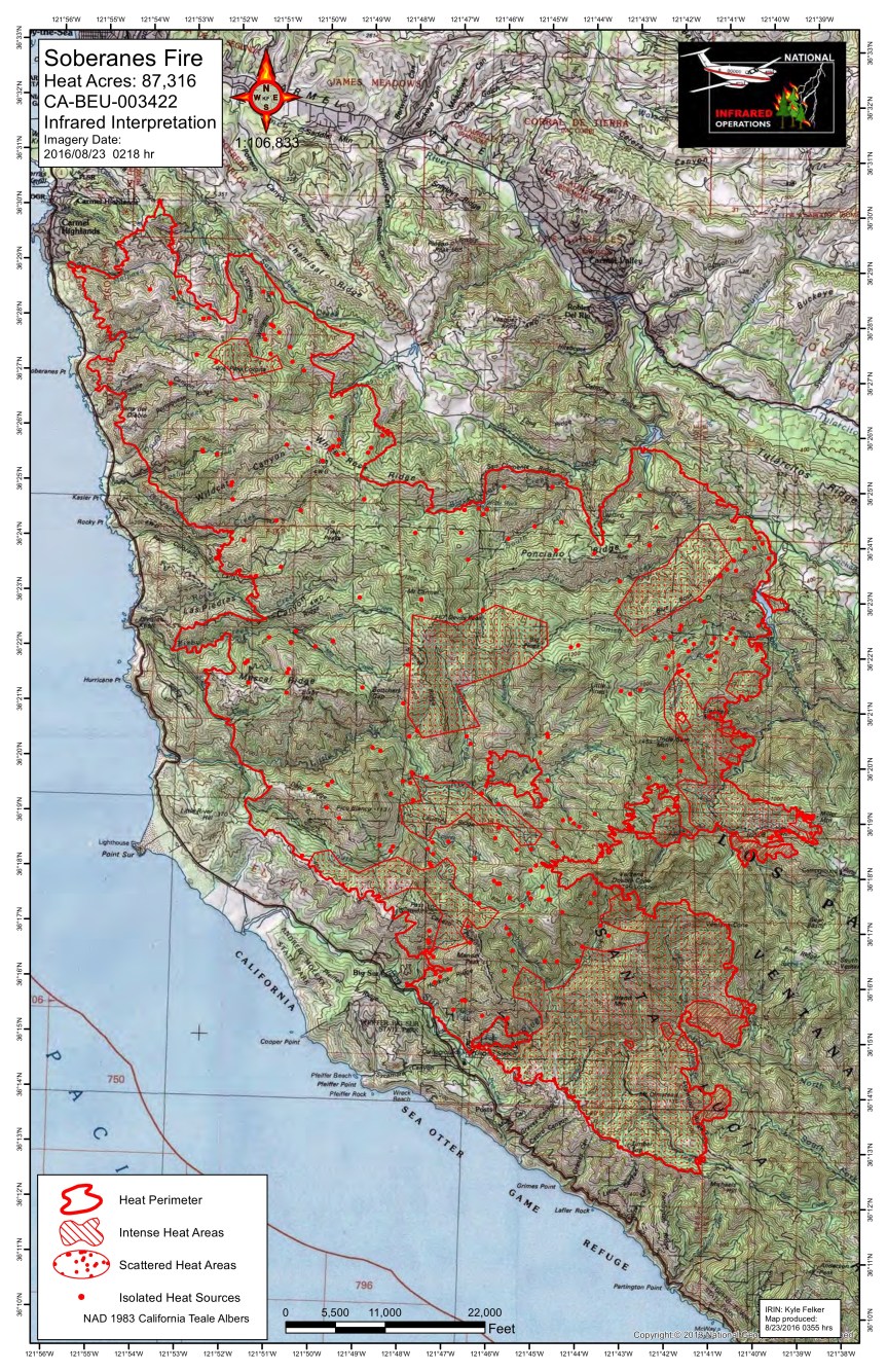
image

Topo PDF map link

image

So Ops PDF Map Link