Soberanes Fire: The Aftermath

Via Andi Elder, I have been watching the amazing work of this group from Ohio – Christian Aid Ministry – who came out here, self-contained it appears – to help those who lost their homes clean up the rubble. I truly admire them. They exemplify the Christian ethic that others just talk about. They have gotten little recognition for what they do, probably because they don’t seek it. I’d like to offer my heart-felt thanks for what they are doing for our community. Andi … Let us know what we can do for them.

I found where you can donate to this specific fund.

Here is their website: Christian Aid Ministries Rapid Disaster Response

imageimageimageimage

The end of coverage – Soberanes Fire

Many of you are so used to waking up to Bigsurkate in your inbox with maps and commentary that you will miss it – not the fire – just the daily connection with community, and eyewitness accounts, and a place to share the horrors and the triumphs. I will, too. But … even the IMT get rotated out every 14-21 days, and I think I am on my 5th such IMT. I need to go back to center, find my balance, and not spend my life on the Internet for a while. It’s not healthy. I know you are all with me on this. I have loved what we have created here, and I am not “leaving” by any means. I still have our events, our clean up, our winter storms and road closures to cover – not to mention lost and found dogs – , but I will be finding center so I can continue to provide service to our community when needed. I can’t thank all of you enough for the experience which has been like no other … We have shown the world the best that we can be, and thus, by extension, the best that they can be.

There are many people who helped these last 71 days, but two stand out: First, Lucas Ryan who did the maps for me for several weeks when all was hot and heavy. I couldn’t have done it without his help. Second was John Chesnut who did his maps for fun every morning while he had his coffee before he ran off to work. You guys were and are amazing. Thank you, so much.

We have some important community issues we need to address – like how we prevent this from happening again – we can share our experience, others can share theirs, and we can hopefully come to some solutions which will benefit all lovers of the land – near and far – so that we can learn, and teach our children, how to be better stewards of the land we love and which gives us all that we are. We are all about sharing solutions after this remarkable experience. Join us … Blessed be.

Soberanes Fire, Day 70, 9/29/16

There is a flair up on Mt. Manuel today, which resulted in the following story and photo:

“Just a kinda funny story. I was in my kayak in pond today around 11:30am. I was tying rope to broken willow trees on the island and then to tractor to pull them out. This was some of the minor damage done from the 6 weeks of dipping during the fire. It’s been around 10 days since the last air operation here so I was surprised when all of a sudden sitting on my kayak in middle of pond I heard a helicopter. Before I knew it I got a visual of a Sikorsky heading my way. I scrambled to get out of pond and move tractor, tools, kayak, etc.

They have been dipping ever since making short trips northeast of here. I’m assuming hitting a flare up in the black?

Thanks again,

Marcus Foster
(Rancho Grande)”
image

As the fire winds down, transitions to a Type 2 IMT today, is over the 90% threshold for containment, so does my coverage of this fire begin to wind down.

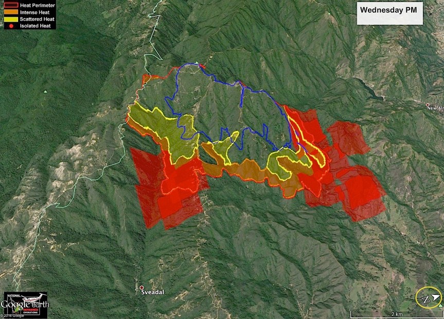
Here is John Chesnut’s map:

image

Basic Information

Current as of September 29, 2016 at 7:19:54 AM PDT
Incident Type Wildfire
Cause Illegal Campfire
Date of Origin Friday July 22nd, 2016 approx. 08:45 AM
Location Soberanes Creek, Garrapata State Park, Palo Colorado/Big Sur, & Ventana Wilderness.
Incident Commander Rocky W. Opliger, USFS, California Interagency Incident Management Team 4.
Incident Description Wildland Fire
Current Situation
Total Personnel 1,462
Size 129,395 Acres
Percent of Perimeter Contained 92%
Estimated Containment Date Saturday October 15th, 2016 approx. 12:00 AM
Fuels Involved
Chaparral, tall grass and timber
Significant Events
Minimal fire activity overnight due to a deep marine layer and high humidity. Interior smoke production and fire activity may be possible do
to the drought stricken fuels, even in areas that have been dormant for weeks.
Outlook
Planned Actions
The North side of the fire continues to be in patrol status.
On the East side of the fire, suppression efforts are being focused on the interior around the Church Creek drainage area, to cut off possible fire growth. Infrared is being utilized to detect heat. Air resources are also being utilized to strengthen containment and treat hot spots on the south side of the Church Creek drainage area with retardant and water drops. Crews are being inserted around the areas that need hot spotting and cold trailing.
Suppression repair plans on the east side of the fire are being implemented.
On the west side of the fire, a more direct attack tactics are being implemented. Crews are being inserted into those areas conducting hot-spotting and cold trailing operations.
A substantial suppression repair effort continues to be a high priority for resources on the west end of the fire.
Projected Incident Activity
Predicted lower temperatures and RH associated with the arrival of a deep marine layer will assist in control efforts. Fire behavior is expected to be moderated under the influence of these conditions.
Remarks
Transition to Central Coast Incident Management Team – Type II, will occur on 9/29/16 at 0800.
Projected final footprint of the fire has been reestablished. Due to the expected consumption of green islands within the interior of the fire, final projected acreage has increased. All acres are accounted for that lie with the containment lines, burned or unburned.
Current Weather
Weather Concerns
Temperatures near active fire area: 55-60 except 70 around the thermal belt.
Relative Humidity near active fire area: 15 to 20% ridges…30 to 45% valleys.
Winds near active fire area:
Valleys: becoming downslope/downvalley 3-5 mph gusts 8 mph.
Mid/Upper Slopes: NW 10 to 15 mph with gusts to 20 mph becoming SW 5-10 mph with
gusts to 15 mph overnight.
Outlook for Today:
Temperatures near active fire area: 80-90
Relative Humidity near active fire area: 11-18%
Winds near active fire area:
Valleys: Upslope/upvalley 5-10 mph gusts 15-20 mph by midday.
Mid/Upper Slopes: SW 5-10 mph gusts
UNIT INFORMATION
USFS Shield
Los Padres National Forest
U.S. Forest Service
6750 Navigator Way
Suite 150
Goleta, CA 93117
INCIDENT CONTACT
Fire Information Line
Phone: 831 204-0446
Hours: 6:00 AM -10:00 PM
RECENT ARTICLES
Soberanes Fire Daily Update for September 28
News – 21 hrs. ago
Soberanes Fire Daily Update for September 27
News – 2 days ago
Evacuation Warning for Arroyo Seco Area Lifted
Announcement – 3 days ago
Sorberanes Fire Daily Update for September 26
News – 3 days ago
RELATED INCIDENT LINKS
If you Fly, We Can’t
One Less Spark
Ready for Wildfire
Ready,Set, Go
Center for Disease Control – Smoke Management Tips
Monterey County Reverse 911 Signup
Wildland Fire Terminology Glossary
Air Quality Index for California
Los Padres National Forest
Temporary Flight Restriction
Firefighting Aircraft Recognition Guide
SPCA Monterey County
CPOA – Coast Property Owners Association Big Sur
The Community Foundation for Monterey County
INCIDENT COOPERATORS
Bureau of Land Management
American Red Cross
Big Sur Land Trust
Big Sur Volunteer Fire Brigade
Cachagua Fire Protection District
CALFIRE
California Conservation Corps
California Department of Fish And Wildlife
California Department of Parks & Recreation
California Department Of Transportation
California Highway Patrol
California State Office of Emergency Services
CalTrans
Carmel Highlands Fire Protection District
County of Monterey
Mid-Coast Fire Brigade
Monterey Bay Air Resource District
Monterey County Regional Fire Protection District
Pacific Gas and Electric
United Way
FOLLOW THIS INCIDENT
Twitter Feed
Article RSS Feed
Google Earth Network Feed
help »
FIRE INFORMATION WEBSITES
Incident Related Links

Loma Fire, 9/29/16

John Chesnut Map; note North is rotated.

image

This fire is now expected to be contained by October 3, 2016. Absent any unusual events, I will only be posting John’s maps, if available, on this fire.

Loma Fire Incident Information:
Last Updated: September 29, 2016 6:30 am
Date/Time Started: September 26,2016 2:42 pm
Administrative Unit: CAL FIRE Santa Clara Unit
County: Santa Clara County
Location: off Loma Prieta Rd and Loma Chiquita Rd 10 miles NW of Morgan Hill
Acres Burned – Containment: 3,849 acres – 22% contained
Structures Threatened: 325
Structures Destroyed: 1 single residence and 6 outbuildings destroyed, 1 single residence damaged
Evacuations: Santa Clara County: Mandatory evacuation orders for the Loma Prieta ridgeline area including all tributary roads along Summit Road from Soquel San Jose Road to Ormsby Fire Station. This includes Uvas Canyon County Park, Loma Chiquita, Casa Loma, and Loma Prieta Way. Portions of Croy Road are under an evacuation warning.
Santa Cruz County: All evacuation orders and warnings have been lifted. Evacuation alerts in Santa Clara County can be received by signing up for AlertSCC, visit: http://www.sccgov.org/sites/alertscc/Pages/home.aspx.

Evacuation Centers: Santa Cruz County Fairgrounds, 2601 East Lake Ave, Watsonville (large animals welcome)
Jewish Community Center of Silicon Valley, 14855 Oka Road, Los Gatos
Morgan Hill Presbyterian Church, 16970 De Witt Avenue, Morgan Hill

Road Closures: Loma Chiquita Road, Summit Road from Soquel San Jose Road to Pole Line Road, Mount Bache Road at Highland Road, Casa Loma Road at McKean/Uvas, Mount Madonna at Ormsby Road Mount Madonna Road at Pole Line Road, Croy Road at Uvas Road is open to residents only
Cause: Under investigation

Loma Fire, 9/28/16

Here is the evening John Chesnut Map of the Loma Fire. We got a two-headed monster going, now. Note that North is rotated to be on the right of the map.

image

John Chesnut MAP

image

Here is today’s Topo IR map and the daily update. Today is a town run day for me, so won’t be available much of the day.

image

IR Topo Map in PDF
Last Modified on September 28,2016
LOMA FIRE

Loma Fire Incident Information:
Last Updated: September 28, 2016 6:30 am
Date/Time Started: September 26,2016 3:06 pm
Administrative Unit: CAL FIRE Santa Clara Unit
County: Santa Clara County
Location: off Loma Prieta Rd and Loma Chiquita Rd 10 miles NW of Morgan Hill
Acres Burned – Containment: 2,250 acres – 10% contained
Structures Threatened: 300
Structures Destroyed: 1 single residence and 6 outbuildings destroyed, 1 single residence damaged
Evacuations: Mandatory evacuation orders for the Loma Prieta ridgeline area including all tributary roads along Summit Road from Soquel San Jose Road to Ormsby Fire Station. This includes Uvas Canyon County Park, Loma Chiquita, Casa Loma, Loma Prieta Way, Highland Road and Mount Bache Road. Portions of Croy Road are under an evacuation warning.
Reverse 911 calls have also been sent to residents using Alert SCC. If you have not already signed up for AlertSCC visit http://www.sccgov.org/sites/alertscc/Pages/home.aspx.

Evacuation Centers: Santa Cruz County Fairgrounds, 2601 East Lake Ave, Watsonville (large animals welcome)
Jewish Community Center of Silicon Valley, 14855 Oka Road, Los Gatos
Morgan Hill Presbyterian Church, 16970 De Witt Avenue, Morgan Hill

Road Closures: Loma Chiquita Road, Summit Road from Soquel San Jose Road to Pole Line Road, Mount Bache Road at Highland Road, Casa Loma Road at McKean/Uvas, Mount Madonna at Ormsby Road Mount Madonna Road at Pole Line Road, Croy Road at Uvas Road is open to residents only
Cause: Under investigation
Cooperating Agencies: California Highway Patrol, Santa Clara County Sheriff’s Office, Santa Cruz County Sherriff’s Office, California Department of Corrections and Rehabilitation, San Jose Water Company, Santa Clara Valley Water District, Pacific Gas and Electric and Santa Clara County Office of Emergency Services.

Soberanes Fire, Day 69, 9/28/16

Current Size: 128,595 acres (91,401 acres Los Padres National Forest; 37,194 acres CAL FIRE)
Containment: 89% Personnel: 1,833

John Chesnut Map:

image

I haven’t been able to get the IR Topo map, yet, but here is the Briefing Map, to start …

And now, the IR Topo:

image

IR Topo Map in PDF


image

Briefing Map in PDF

Fire Behavior and Weather Predictions Discussions:

imageimage

Welcome new Cal Trans Supervisors!

From Cal Trans: “I am pleased to announce the appointment of Scott Pryor as the new Maintenance Supervisor for the Willow Springs Maintenance crew effective October 1, 2016. Scott is currently the Leadworker in King City. Scott is a local King City resident. He and his family are looking forward to his new adventures on the Big Sur coast.”

image

“Also, we are pleased to announce the appointment of Heath Johnston as the new Maintenance Supervisor for Big Sur effective October 1, 2016. Heath is currently the Leadworker for Big Sur Maintenance and is enjoying his new life on the coast with his gal Meg and Dog Blaze.”

image

Welcome to the coast, Scott, and welcome to your new position, Heath. Look forward to working with both of you this winter to keep travelers aware of any issues with our Highway.