Soberanes Fire Day 17 Images; Big Sur

Mike here with a few images of the setting in Big Sur between Molera and Big Sur Station from late morning today. Pictures here don’t represent the stiff wind blowing from the north.

August7Fire9336

What appears to be a  USFS hand crew preparing a fuel break of some sort from an established path just south of Big Sur Station about 300 yards from Highway One.

August7Fire9371

Andrew Molera State Park parking lot is being used as a refueling station for engines, crew buses and utility vehicles.

August7Fire9341

Four water dropping helicopters are ferrying water to the peaks above Big Sur Valley from a source provided by El Sur Ranch close to Andrew Molera State Park boundary.

August7Fire9383

Two water dropping Sikorsky skycranes are working together south of where the smaller copters are working. They were observed dropping loads  behind Mt Manuel. They may be reloading in the ocean off Pfeiffer.

August7Fire9350

Soberanes Fire, Day 17, 8/7/16 – Local Reports

9:00 pm – I am trying to catch up with my email, FB, Twitter, etc. after  a day on the road and the fundraiser tonight. (Sorry I couldn’t stay around, it was way too crowded and way to loud for this gal.) I had hoped to meet some of you, but it just wasn’t to be. There is so much to say, and do, and be, but after 17 days, I am tired … As we all are. I don’t hold the title to that, we do. The battle is not over, in fact, in some ways, it has just begun for Big Sur, and I need to get up to fighting speed and strength again. I may not wake at 6 am tomorrow, as I am no longer at home with the early dawn of elevation looking down on me and nudging me toward wakefulness. I am in unfamiliar territory where my exhaustion may win. Rest, but be ever vigilant, as this monster does not want to let go.

Sikorsky @Rancho Grande by Heather Foster:

image

Evacuation of Big Sur clarification:

image.jpeg

2:30 pm – Scott Moffatt has some incredible photos of the progression of the fire starting at 4 am.

Scott Moffatt Photos

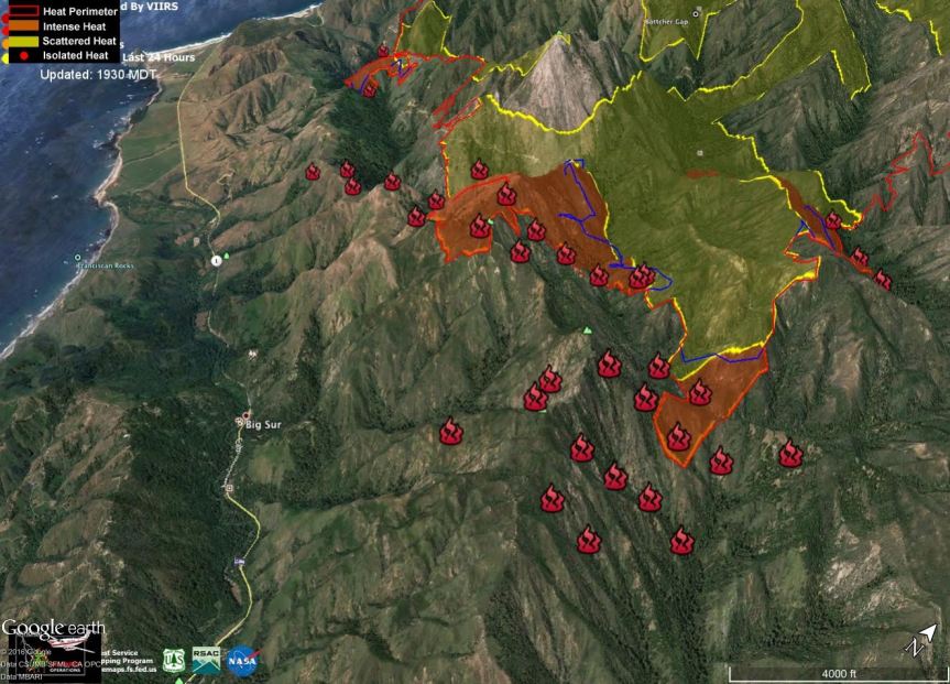
1:30 pm – drove through the entire length of Big Sur this morning. It was so smokey, I couldn’t see much of anything. ALL the businesses were closed, from Deetjen’s to River Inn, but the tourists were flocking through. There was little police presence, only at Sycamore’s Hard Closure. Tourists were tearing down the yellow tape all over JPBurns, but I saw no one of authority.

That makes perfect sense … Keep the people out who know the area and know how to be safe, who have lived through numerous wildfires, and let the clueless tourist wander about with abandon.How was this for the local’s safety, again? What am I missing here? In what uninverse is a wildfire safer for the clueless than for the experienced?

12:30 pm – just had lovely lunch at Sur. When I get settled in up here I will tell you my observations driving through Big Sur.

This is Stan Russell and appears to be the “party line” and not what I am hearing or observing. “The evacuation notice issued last night was issued because a 40 MPH wind kicked up and pushed the fire over the dozer line. The slop over fire was a 100 acres. This is the main fire that made the run.

Operations today; they are burning off the dozer lines – back firing. The operation is going well. (Really??)

They will have full air support as soon as they can fly safely. They also have portable fire retardant stations to load up the helicopters.

They weren’t able to back burn the area behind Mount Manuel yesterday.

There will be Public Information Officers posted today at Big Sur Station, Post Office area, Big Sur Bakery, Fernwood Resort, Nepenthe, Ripplewood, and I recommended posting one at the River Inn which he said he would do. They will have sandwich boards with maps and be able to answer your questions.”

At this point the Sheriff’s Department is NOT closing Highway 1, which makes no sense. As one business manager says, “The tourists are allowed in but owners and workers aren’t?”

7:00 am – from Ken Wright who says flames are visible in the north fork of Juan Higuera

image

7:00 am – From Jen Smith on Clear Ridge

image

7:00 am – From Ed Van Weijen on Clear Ridge

image

7:00 am – For all of those asking if Highway One is open — I don’t know, yet, but PLEASE, if you don’t have any business being down here, don’t come. All businesses have been evacuated and are telling employees not to come to work. We don’t need any more gawkers. AND just got word it is expected to close this am at Bixby Bridge.

6:45 – Dawn on Mt Manuel from Pfeiffer Ridge by Kyle Evans

image

6:30 am – by now, all of you have heard of the evacuation order for Big Sur Valley from the Lighthouse to just north of Deetjen’s, both sides. I will be following developments throughout the day, however, I will be heading out the door at 8:30 am into cell phone no-man’s land for a while. When I have reception again, I will check in. This is my day to go north to Monterey for a couple days of R&R. (LOL, as if) but will be online on and off.

Soberanes Fire, Day 17, 8/7/16 – Maps, etc.

To give you an idea of where the Soberanes Fire is burning, we’ve included maps that are updated daily. These maps are provided by Cal Fire/US Forest Service.

The latest Heat Perimeter was detected yesterday around 9:30 pm.  You can see the latest Heat Perimeter on the Infrared Topo and Ortho maps.

We’ve also included the Weather Forecast, Fire Behavior Forecast and various links that you may find useful. Note: Additional links are located at the end of the post. Some links may open large PDF documents.

Please see Local Reports for the current fire discussion.

Infrared Topo: IR_Topo0001b

Infrared with Satellite Image: IR_Ortho0001c

IR Logl

Weather Forecast0004.jpg

Fire Behavior Forecast0005.jpg Operations Map North: Ops North0002.jpg

Operations Map South: Ops South0003.jpg

LegendLegend

Briefing Map: BAM0001.jpg

The following are KMZ IR flight overlaid on Google Earth. Last satellite pass was about 3 AM local. Blue line is the FridaySaturday night perimeter to show immediate spreading rate. Images provided by of John Chesnut. As always, please remember that false readings do occur.

Big Sur:Post Summit

Big Sur with the VIIRS satellite returns (hot spots):bigSur Icon

VIIRS heat records for Big Sur on Sunday Afternoonunnamed

Cachagua:Cachagua Summit

Links:

Xasauan Today Satellite heat detection discussion

Google Maps (not current) Adam Clark’s Google Map with most recent Dozer lines, IR flight overlay, and the Planned Fire Line. Note: You may need to be signed in to a Google account to view this link.

Mapping Support (not current) Same as above, but on USGS Topo Maps

MesoWest Weather stations that are located near the fire. Scroll down to S07 Central Coast IRAWS. See the Blue WX rectangles on the Ops maps for locations. There are currently 7 portable weather stations deployed.

Flight Radar 24 Live Air Traffic for the area.  Note: aircraft flying at low altitudes may not be detected.

Additional Cal Fire/ US Forest Service Links:

INCIDENT PLAN Complete Incident Plan as of 8/7/16. Note: PDF may take awhile to download

IAP MAP CARMEL Dozer Carmel as of 8/7/16

IAP MAP SECO Dozer Seco as of 8/7/16

IAP MAP SUR Dozer Sur as of 8/7/16

PIO Public Information Map as of 8/6/16

Air Operations Map Air Ops as of 8/7/16

Air Operations HELCO Map HELCO as of 8/6/16

Firefighting Aircraft PDF guide with Cal Fire Firefighting Aircraft

SITUATION Situation Map as of 8/2/16 shows previous fire outlines

ELEVATIONS Elevations Map as of 8/2/16 shows hills and valleys in various colors

Evacuation of Big Sur

6:30 am – Apple Pie Ridge is fine, they have Cal Fire up there with them, this time. And remember, we fought this before in 2008 and can do it again. I will be off for regular reporting now, Lucas will get the maps up and I will start the local reporting page momentarily.

IF Map released around 5 am –

image

5:00 am – Too close to home From a friend up on Apple Pie Ridge

image

4:14 am –  report from a resident on Pfeiffer Ridge … “there’s now a separate front coming over the ridge just east of Mt Manuel. Can see flames peeking over the ridgeline…”

Remember, reports received in the middle of the night, under stressful situations should be viewed with caution. Dawn will bring more accurate reports.

A reverse 911 call at 3:15 called for the evacuation of Big Sur, per a reader who commented:

“This just in via reverse 911: “This is a notification from Alert Monterey County:

The Monterey County Sheriff”s Office has ordered a Mandatory Evacuation for the Big Sur Area from the Point Sur Lighthouse to Graves Canyon. The Evacuation Center is the All Saints Day School at 8060 Carmel Valley Road.”

Sheriff’s office confirmed, order came straight from Cal Fire.”

It is so strange. I woke just a few minutes before this was issued, came in and sat down at my iPad, see emails re fire approaching valley, and while I am reading, I get notice of the reverse 911 call. Eerie.