8:00 pm – and to end my evening postings, here are some just-taken photos of the drop on Mt. Manuel summit by Ed Van Weijan
This slideshow requires JavaScript.
7:30 pm –
View from Osborne Ridge above Stonepine in Carmel Valley by Shadd Madsen

View from Tularcitos by Emily Miller

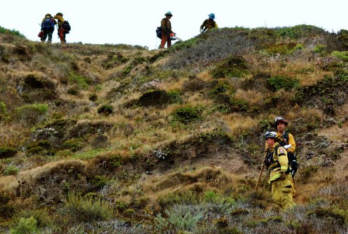
5:22 pm – report from Rolf Ridge on Sky Ranch/Cachagua
A slow start to the day gray and still. Action picked up a lot in the afternoon. Light sea breeze marine layer about 2500 feet. Smoke not bad at Sky Ranch.
A planned burn is happening this afternoon from the road into Los Padres Dam – Nason Rd – up the ridge to the right (north). Then the fire line cuts back away from Cachagua rd, up a long valley towards san clemente, white rock, etc. to the northwest.
So it follows the ridge to the right from downtown Cachagua, then at the top of that ridge (flagpole up there) it cuts back and away from the ridgeline and towards what someone said is the san carlos preserve airstrip, where the second plume is, up that valley. That looks like a planned burn too, higher up where the line down here extends off that way.
Off in the far distance is a 3rd plume, too far away to figure out – but 3 plumes!
It really started burning well around 4 pm. It looks to be perfectly executed and totally in control. There is a lot of smoke going south to southwest, at least in the first 2500 feet of atmosphere.
—
Rolf J. Ridge
Photos of the burn out operation:
This slideshow requires JavaScript.
5:15 – here is the back burn at Soberanes Park being conducted right now. The smaller fires are the spot fires, and the rest is just the fire, “doing its thing.” And yes, the Highway is still open. Please don’t shoot the messenger! Sent by a friend.

5:00 – crews coming in to establish a fire break in or near Hitchcock Canyon, photos by Joanne May:
4:30 pm – backburn north of Syndicate Camp by Mary Martin:

3:30 pm – hearing reports from a local that the CHP is advising that a back burn from the Highway at the Soberanes State Park, the place where it all began, will be initiated soon.
Also, scanner report of a dozer who stumbled upon a pot farm just now being attacked by the growers. H70 circling overhead, and 3 quads on way up. I hope they are caught. Watch your local news for further, as I won’t cover this crap in the midst of bigger things, as long as the operator is okay. If he is not … I’ll be back fuming.
3:00 pm – from county communications:
For folks who need their parcel number, here is how you can find your number online. The Assessor’s Office is backlogged helping folks.
Maia
If you are affected by the Soberanes Fire and need your parcel number, you can find it on the Monterey County Assessor’s Office webiste at http://www.co.monterey.ca.us/government/departments-a-h/assessor/assessor-county-clerk-recorder.
Click ‘On Line Services’ then Search and Return Map Pages. Use the ‘Property Search’ function to get your parcel number.
12:15 pm – dozers have arrived at Joanne May’s Ranch near Garland Park to put in a fire break. All clapping down there.
11:44 – from the Deli:

11:14 – whoa, shit! Huge plume toward Cachagua Way (I think), hopefully a back burn, and a smaller plume toward the coast.

10:51 am – Slide show of fire and prep at White Rock, photos sent by Joe Pagnella
This slideshow requires JavaScript.
10:00 am – COMMUNITY MEETING TONIGHT IN CV

8:00 am – Official Fact sheet lists over 40K acres and 18% burned, no increase in structures lost. Otherwise pretty much the same as last nights posted below.
Also an update: From Bruce Dormody, Rancho San Clemente at 7:16 am: Last night they started a back fire from the Airfield…it was too windy in the wrong direction so they put it right out. This morning they have restarted it, and it looks to be preforming nicely. Their goal is burn 60 to 100’ off the inside and bolster the dozer and hand lines. They have roughly 100 folks up there to watch over everything, so at this moment I feel pretty good…but to give you some idea, they have 5 miles of line to back fire just for our rancho…this will go on for the next few days. The fog is in in the cabin area and temperatures have cooled…but it is extremely smoky. They have cut power to the Ponciano (the break runs under the power lines) and the truck traffic is comically crazy…just imagine 40 big trucks going up to the Bass Lake…then 20 minutes later heading back to the pool, only to turn around an hour later and head back up…so it’s hard to get around anywhere. Thanks again for your kind words…the heavy work is just about done for us (still applying gel retardant to some of our buildings) so now it’s really just watching over everything. Bruce >
7:20 am – Adding info people have sent me, often through PM on FB from all over the fire area:

From last night, as I was getting ready to call it a day:
From Joanne May:
“Hi Kate – Update……I gave fire crews a tour of my ranch today and showed them where to connect into Garland. Tomorrow, dozers will be creating a secondary line of defense from Garland, across my ranch, hand crews will work down and up the canyon, making their way to Cachagua. The fire fighters are amazing and working so hard to help us. And, we are helping one another. Just thought you would want a progress report from Snively’s Ridge in Carmel Valley. Tired. Hope this makes sense.”
from Mike Selig:
“For those that need help from the Monterey County Assessor’s Office regarding parcel numbers – folks who may not have a specific address – you can call the Assessors Office Monday. Staff there to help are Emma Rayas and Marcello Ramirez.
If you need deeds, documents, certificates, contact Alicia Sotelo.”
6:30 am – I look out at that gorgeous view, see virtually no smoke, and definitely no plumes, and momentarily can wake to the hope that the nightmare is over, knowing it is not. I had the best night’s sleep thus far last night – 11-6. Sweet. A cuppa Joe to top it off this am, and I’ll be ready to slay the dragon again from my perch on top of the world …
Thanks to Lucas Ryan for the new, streamlined, but highly informative format for the Maps post below. I think you’ll enjoy what he has done.
Give me 1/2 an hour, and I’ll be off and running again for the day.
From Michael Troutman:


 Legend
 Public Information Map (full-size PDF here:
 Infrared with Satellite Image (full-size PDF here:
  Infrared Log
 Weather Forcast
 Fire Behavior Forcast
 Dozer Index

 Dozer Maps (select map to open preview, “view full-size” link located below preview)


