

Planned Closure of Highway One tomorrow

8/15/16 –
5:00 pm – 50 acre spot fire on West Side of Lake
7 am – 4300 acres and 10% containment. Here is John Chesnut’s MODIS map of the Chimney Fire:

8/14/16 –
5:45 pm by Bill Mortiz

Today around 3 pm from Cambria by Joan Schlicher. Rocky Butte is on the right. Looks like a nuclear explosion.

3:25 – right now, photo by Michael Handy:

3:00 pm – SLO County Offices of Emergency Services says the fire has quickly exploded and those in the Tri-County and Cal Shasta area are to evacuate immediately. Those who can not get out of the area are to go to water’s edge where the SLO County Sheriff’s will be launching boats for evacuations.
10:30 am –
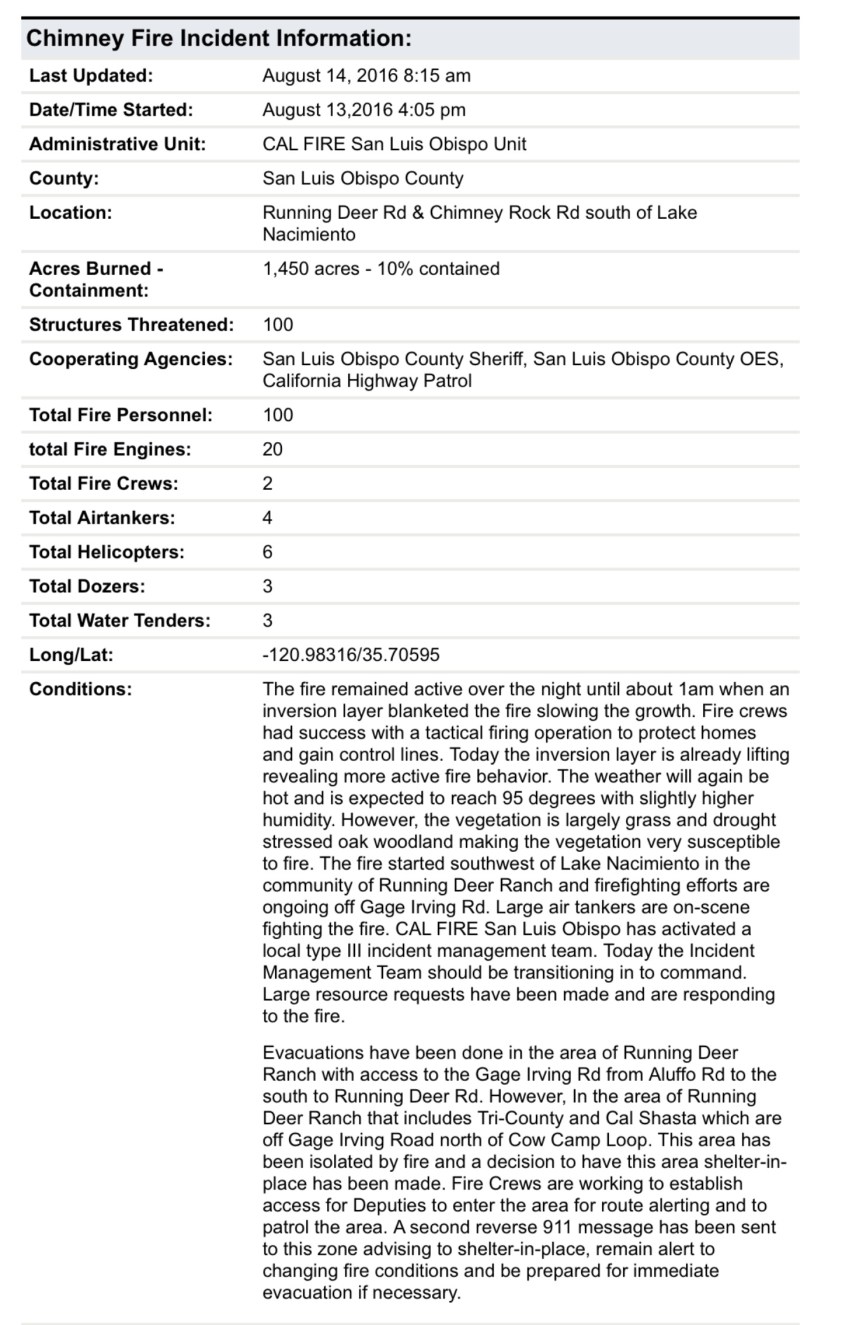
8:00 am – acreage updated to 1450 acres, 10% containment.
6:30 am – Chimney Fire is now 1000 acres and 10% contained. Here is the most recent MODIS from John Chesnut:

***********************************************************************
9:pm – latest update is 850 acres, back burns initiated and going well, VLAT photo by Rick Modlin:

Here’s an aerial:

5:10 pm – AA says multiple spots up to a mile ahead of the main fire are starting to take off, fire now 350 + acres, now 450 acres. BTW, it is 107 by the Paso Airport, so it will be about the same here.
5:00 pm – As if my life wasn’t busy enough – this is a lot of fun … A fire just broke out ESE of me on the West side of Lake Naciemento. It is 100-200 acres and moving fast. It is on Chimney Rock RD. Near Running Deer Ranch, which is being evacuated. 5 tankers assigned at this point. This could get interesting – one to the north west of me and one to the south east. Hmmm…Here is what it looks like.

8:30 pm – today’s burn out operation om the west side of the fire as a slide show from Kyle Evans:
7:30 pm – Here is “find the firefighters” by Jeff Mallory

That is some steep country.
5:15 pm – from Steve Harper, edited for brevity and clarity:
To the left you can see mt Manuel and where the fire has stopped burning. You can see the Mt Manuel trail on the left and the Pine Ridge trail on the right. The very steep hand line is on the south side of the river and is running down the the back loop of the State Park campgrounds.

Anyway here is the photo. You can see the flank of Mt Manuel and the Mt Manuel trail and the road that goes up to the SP water tank, and the water tank itself. Further north are the ridges, some with visible flames. Steve Harper thinks the Gorge will be a problem, as he evidenced by asking about it at the last meeting.

00 pm – well this is a lot of fun … A fire just broke out WSW of me on the West side of Lake Naciemento. It is 100-200 acres and moving fast. This could get interesting – one to the north west of me and one to the south east. Hmmm…Moving to new post, will keep this one focused on Soberanes.
From Ken Wright at 4:18 pm – “Firing from Juan Higuera along the slope South the Gorge and beyond.” 1/2 hour later, Ken reports the back fire seems to be going perfectly. Here’s the view of it from Clear Ridge by Jen Smith:

3:45 pm – near Hopkins Ridge, by Kyle Evans

1:45 pm – Juan Higuera from Clear Ridge by Jeff Mallory:

12:30 pm – getting questions about the warned-about road closure, but I have heard nothing. One local in a burn out area was told (unknown level of authority) that if things didn’t go well with the burn out operations currently being conducted, a closure could be ordered. So far, all reports are that it is going well.
11:30 am – this is where the firing operation is going on – between Div breaks of N and O. It’s been going on for a while, per Soaring’s comment. My understanding (not a “for sure” thing by any means) is that the plan is to continue burn out operations, as weather permits down that dozer line through “N” to Div “ZZ” and further down, ahead of the main fire. This plan, of course, can change as the weather changes or the fire does.

9 am – today’s acreage is listed as 71,860 with containment at 60%. Want to know how the backburn on Coast Road is doing? Read Soaring’s eloquent and moving account in the comments section on this post. Made my day. Also reported that the backburn on the handline at Juan Higuera is going well, as well.
7 am – just a reminder, then I will be back later.

To give you an idea of where the Soberanes Fire is burning, we’ve included maps that are updated daily. These maps are provided by Cal Fire/US Forest Service.
The latest Heat Perimeter was detected yesterday at 9:00 pm. You can see the latest Heat Perimeter on the Infrared Topo map. Note: The Heat Perimeter is not current on any other Official Map.
We’ve also included the Weather Forecast, Fire Behavior Forecast and various links that you may find useful. Note: Additional links are located at the end of the post. Some links may open large PDF documents.
Please see Local Reports for the current fire discussion.
Infrared Topo: IR_Topo Infrared Ortho: IR_Ortho
 IR Log
 Weather Forecast
 Fire Behavior Forecast
 Operations Map North: Ops North
 Operations Map South: Ops South
Legend
Briefing Map: BAM Progression Map: Progression Map
Three views from the overnight flight and morning Satellite hits (provided by John Chesnut)
Saturday AM: Apple Pie Burnout:
 Cachagua Saturday AM:
Links:
Xasauan Today Satellite heat detection discussion
Google Maps Adam Clark’s Google Map with most recent Dozer lines, IR flight overlay, and the Planned Fire Line. Note: You may need to be signed in to a Google account to view this link.
Mapping Support Same as above, but on USGS Topo Maps
MesoWest Weather stations that are located near the fire. Scroll down to S07 Central Coast IRAWS. See the Blue WX rectangles on the Ops maps for locations. There are currently 7 portable weather stations deployed.
Flight Radar 24 Live Air Traffic for the area. Note: aircraft flying at low altitudes may not be detected.
Additional Cal Fire/ US Forest Service Links:
INCIDENT PLAN Complete Incident Plan as of 8/13/16. Note: PDF may take awhile to download
IAP MAP CARMEL Dozer Carmel as of 8/13/16
IAP MAP SECO Dozer Seco as of 8/13/16
IAP MAP SUR Dozer Sur as of 8/13/16
Public Information Map PIO as of 8/13/16
Air Operations Map Air Ops as of 8/13/16
Firefighting Aircraft PDF guide with Cal Fire Firefighting Aircraft
SITUATION Situation Map (not current) as of 8/2/16 shows previous fire outlines
ELEVATIONS Elevations Map (not current) as of 8/2/16 shows hills and valleys in various colors